Property Record
1100 W Highway 10 St Nw, Anoka, MN 55303

NEARBY LISTINGS FOR SALE OR LEASE
-
-
View all Anoka listings for sale on LoopNet.com
Property Detail
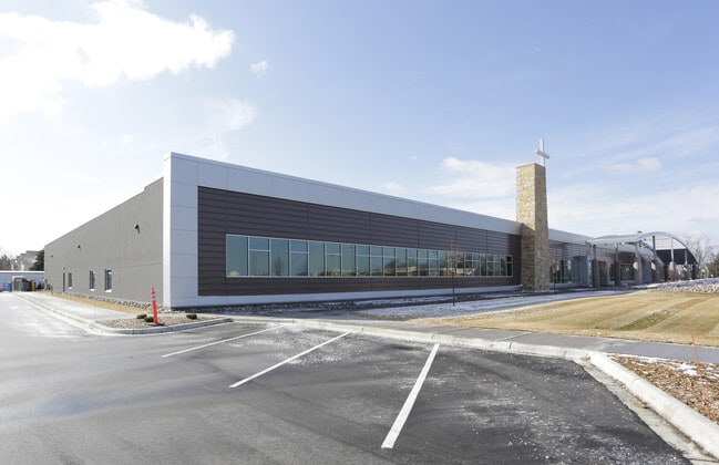
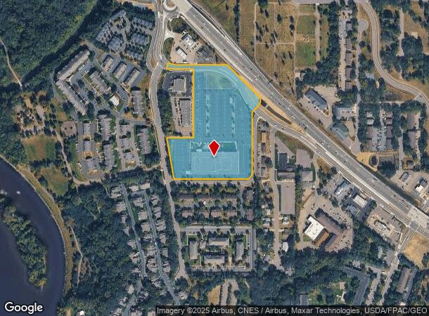
1100 W Highway 10 St Nw
Minneapolis-St. Paul-Bloomington, MN-WI
Cutters Grove 2Nd Add
02-31-25-11-0013
LOT 1 BLOCK 1 CUTTERS GROVE 2ND ADD
Taxexempt
Anoka
X
Minnesota
27053C0058F
1
2025
10.72 AC
2025
Suburban St Paul
050402
Minneapolis/St Paul
61,920 SF
DEMOGRAPHICS near 1100 W Highway 10 St Nw
1 Mile
3 Mile
5 Mile
2024 Total Population
5,663
52,233
113,116
2029 Population
5,855
53,842
115,774
Pop Growth 2024-2029
+ 3.39%
+ 3.08%
+ 2.35%
Average Age
41
40
40
2024 Total Households
2,437
20,396
42,315
HH Growth 2024-2029
+ 3.57%
+ 3.15%
+ 2.42%
Median Household Inc
$73,676
$85,159
$92,082
Avg Household Size
2.30
2.50
2.60
2024 Avg HH Vehicles
2.00
2.00
2.00
Median Home Value
$293,512
$296,477
$301,568
Median Year Built
1977
1987
1986
Nearby Places
Map Layers
Map Styles
 Street
 Aerial
- Restaurants
- Banks
- Shops
- Fitness
- Groceries
PUBLIC TRANSPORTATION
COMMUTER RAIL
Anoka Station (Northstar Corridor - Northstar Commuter Rail)
DRIVE
WALK
Distance
Anoka Station (Northstar Corridor - Northstar Commuter Rail)
6 min
2.5 mi
Coon Rapids-Riverdale Station (Northstar Corridor - Northstar Commuter Rail)
DRIVE
WALK
Distance
Coon Rapids-Riverdale Station (Northstar Corridor - Northstar Commuter Rail)
7 min
4.7 mi
AIRPORT
Minneapolis-St Paul International/Wold-Chamberlain
DRIVE
WALK
Distance
Minneapolis-St Paul International/Wold-Chamberlain
40 min
35.5 mi
Freight Ports
Port of Shreveport
DRIVE
WALK
Distance
Port of Shreveport
1 min
888.2 mi
Nearby Properties
Address
Land Use
TOTAL SIZE
Lot Size
Zoning
Address
Land Use
TOTAL SIZE
Lot Size
Zoning
517,619 SF
3.85 AC
Address
Land Use
TOTAL SIZE
Lot Size
Zoning
468,099 SF
5.73 AC
MSMU
Address
Land Use
TOTAL SIZE
Lot Size
Zoning
3.80 AC
Address
Land Use
TOTAL SIZE
Lot Size
Zoning
3,491 SF
3.03 AC
Address
Land Use
TOTAL SIZE
Lot Size
Zoning
2,400 SF
72.45 AC
Address
Land Use
TOTAL SIZE
Lot Size
Zoning
5,110 SF
38.62 AC
Address
Land Use
TOTAL SIZE
Lot Size
Zoning
122,816 SF
27.84 AC
Address
Land Use
TOTAL SIZE
Lot Size
Zoning
363,449 SF
82.99 AC
R-1
Address
Land Use
TOTAL SIZE
Lot Size
Zoning
68,362 SF
Address
Land Use
TOTAL SIZE
Lot Size
Zoning
225,748 SF
Address
Land Use
TOTAL SIZE
Lot Size
Zoning
129,060 SF
10.21 AC
Address
Land Use
TOTAL SIZE
Lot Size
Zoning
382,508 SF
Address
Land Use
TOTAL SIZE
Lot Size
Zoning
343,297 SF
25.42 AC
M-1
Address
Land Use
TOTAL SIZE
Lot Size
Zoning
153,964 SF
3.90 AC
Address
Land Use
TOTAL SIZE
Lot Size
Zoning
140,288 SF
5.12 AC
Address
Land Use
TOTAL SIZE
Lot Size
Zoning
300,547 SF
19.21 AC
Address
Land Use
TOTAL SIZE
Lot Size
Zoning
298,148 SF
17.70 AC
M-1
Address
Land Use
TOTAL SIZE
Lot Size
Zoning
319,019 SF
17.14 AC
Address
Land Use
TOTAL SIZE
Lot Size
Zoning
114,281 SF
3.19 AC
PRD-4
Address
Land Use
TOTAL SIZE
Lot Size
Zoning
319,664 SF
19.62 AC
M-1
Address
Land Use
TOTAL SIZE
Lot Size
Zoning
436,117 SF
17.75 AC
M-1
Address
Land Use
TOTAL SIZE
Lot Size
Zoning
190,285 SF
12.98 AC
Address
Land Use
TOTAL SIZE
Lot Size
Zoning
Address
Land Use
TOTAL SIZE
Lot Size
Zoning
118,208 SF
Address
Land Use
TOTAL SIZE
Lot Size
Zoning
Address
Land Use
TOTAL SIZE
Lot Size
Zoning
155,849 SF
0.83 AC
Address
Land Use
TOTAL SIZE
Lot Size
Zoning
201,859 SF
9.21 AC
Address
Land Use
TOTAL SIZE
Lot Size
Zoning
811,860 SF
Address
Land Use
TOTAL SIZE
Lot Size
Zoning
100 SF
5.42 AC
R-2
Address
Land Use
TOTAL SIZE
Lot Size
Zoning
60,588 SF
4.56 AC
The World's #1 Commercial Real Estate Marketplace
Connect with us
© 2025 CoStar Group
The information above has been obtained from sources believed reliable. While we do not doubt its accuracy we have not verified it and make no guarantee, warranty or representation about it. It is your responsibility to independently confirm its accuracy and completeness. Any projections, opinions, assumptions, or estimates used are for example only and do not represent the current or future performance of the property. The value of this transaction to you depends on tax and other factors which should be evaluated by your tax, financial, and legal advisors. You and your advisors should conduct a careful, independent investigation of the property to determine to your satisfaction the suitability of the property for your needs.