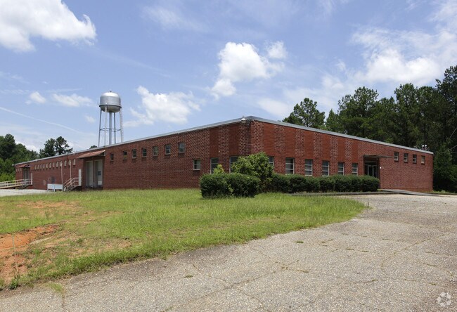
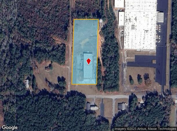
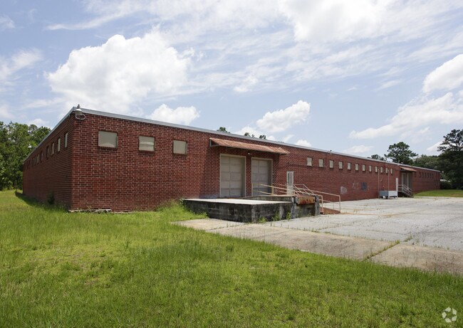
Property Record
1100 W Main St, Manchester, GA 31816
NEARBY LISTINGS FOR SALE OR LEASE
Property Detail
1100 W Main St
MA02-008
2Nd Ld Trt A
Manufacturinglight
COMM BLDG/LL 212 2ND LD TRT A
X
Meriwether
13199C0282E
Georgia
2024
4.74 AC
2024
Meriwether County
970502
Atlanta
27,000 SF
Atlanta-Sandy Springs-Roswell, GA
DEMOGRAPHICS near 1100 W Main St
1 Mile
3 Mile
5 Mile
2024 Total Population
1,869
5,501
7,773
2029 Population
1,919
5,668
7,984
Pop Growth 2024-2029
+ 2.68%
+ 3.04%
+ 2.71%
Average Age
42
42
43
2024 Total Households
786
2,289
3,271
HH Growth 2024-2029
+ 2.54%
+ 2.88%
+ 2.57%
Median Household Inc
$46,677
$39,767
$42,471
Avg Household Size
2.30
2.30
2.30
2024 Avg HH Vehicles
2.00
2.00
2.00
Median Home Value
$138,125
$133,534
$135,445
Median Year Built
1966
1974
1977
Nearby Places
Map Layers
Map Styles
 Street
 Aerial
- Restaurants
- Banks
- Shops
- Fitness
- Groceries
PUBLIC TRANSPORTATION
AIRPORT
Columbus
DRIVE
WALK
Distance
Columbus
54 min
35.0 mi
SALE & LEASE HISTORY
LISTING DATE
SALE/LEASE

Sep 25, 2016
For Lease
Sep 24, 2016
For Sale
Oct 10, 2018
For Lease
Oct 10, 2018
For Sale
Nearby Properties
Address
Land Use
TOTAL SIZE
Lot Size
Zoning
Address
Land Use
TOTAL SIZE
Lot Size
Zoning
32,606 SF
0.89 AC
001
Address
Land Use
TOTAL SIZE
Lot Size
Zoning
30,043 SF
11.22 AC
001
Address
Land Use
TOTAL SIZE
Lot Size
Zoning
25,724 SF
0.67 AC
001
Address
Land Use
TOTAL SIZE
Lot Size
Zoning
13,396 SF
0.72 AC
001
Address
Land Use
TOTAL SIZE
Lot Size
Zoning
153,000 SF
30.50 AC
001
Address
Land Use
TOTAL SIZE
Lot Size
Zoning
5,200 SF
5.87 AC
001
Address
Land Use
TOTAL SIZE
Lot Size
Zoning
7,500 SF
3.67 AC
001
Address
Land Use
TOTAL SIZE
Lot Size
Zoning
51,210 SF
10.56 AC
001
Address
Land Use
TOTAL SIZE
Lot Size
Zoning
50,324 SF
9.43 AC
001
Address
Land Use
TOTAL SIZE
Lot Size
Zoning
11,688 SF
4.07 AC
001
Address
Land Use
TOTAL SIZE
Lot Size
Zoning
35,529 SF
2.89 AC
001
Address
Land Use
TOTAL SIZE
Lot Size
Zoning
7,161 SF
2.45 AC
R-1
Address
Land Use
TOTAL SIZE
Lot Size
Zoning
20,093 SF
0.19 AC
001
Address
Land Use
TOTAL SIZE
Lot Size
Zoning
1,860 SF
4.02 AC
002
Address
Land Use
TOTAL SIZE
Lot Size
Zoning
64,560 SF
7.71 AC
002
Address
Land Use
TOTAL SIZE
Lot Size
Zoning
13,406 SF
1.83 AC
001
Address
Land Use
TOTAL SIZE
Lot Size
Zoning
418.24 AC
001
Address
Land Use
TOTAL SIZE
Lot Size
Zoning
14,309 SF
5.40 AC
001
Address
Land Use
TOTAL SIZE
Lot Size
Zoning
27,176 SF
3.87 AC
002
Address
Land Use
TOTAL SIZE
Lot Size
Zoning
7,500 SF
23.30 AC
Address
Land Use
TOTAL SIZE
Lot Size
Zoning
348.89 AC
001
Address
Land Use
TOTAL SIZE
Lot Size
Zoning
9,860 SF
1.42 AC
001
Address
Land Use
TOTAL SIZE
Lot Size
Zoning
11,730 SF
0.23 AC
001
Address
Land Use
TOTAL SIZE
Lot Size
Zoning
43,560 SF
9.97 AC
002
Address
Land Use
TOTAL SIZE
Lot Size
Zoning
9,305 SF
4.90 AC
001
Address
Land Use
TOTAL SIZE
Lot Size
Zoning
9,360 SF
2.25 AC
001
Address
Land Use
TOTAL SIZE
Lot Size
Zoning
2,816 SF
7.05 AC
001
Address
Land Use
TOTAL SIZE
Lot Size
Zoning
6,296 SF
6.57 AC
001
Address
Land Use
TOTAL SIZE
Lot Size
Zoning
11,425 SF
1.38 AC
001
Address
Land Use
TOTAL SIZE
Lot Size
Zoning
16,306 SF
2.26 AC
001
The World's #1 Commercial Real Estate Marketplace
Connect with us
© 2025 CoStar Group
The information above has been obtained from sources believed reliable. While we do not doubt its accuracy we have not verified it and make no guarantee, warranty or representation about it. It is your responsibility to independently confirm its accuracy and completeness. Any projections, opinions, assumptions, or estimates used are for example only and do not represent the current or future performance of the property. The value of this transaction to you depends on tax and other factors which should be evaluated by your tax, financial, and legal advisors. You and your advisors should conduct a careful, independent investigation of the property to determine to your satisfaction the suitability of the property for your needs.