Property Record
1100 W Mcleroy Blvd, Saginaw, TX 76179
NEARBY LISTINGS FOR SALE OR LEASE
Property Detail
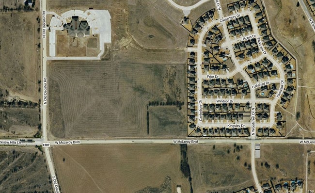
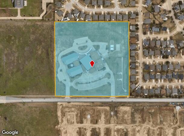
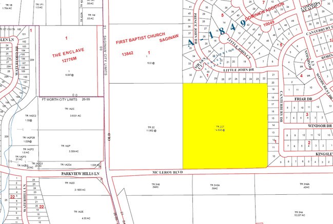
1100 W Mcleroy Blvd
Dallas-Fort Worth-Arlington, TX
Mcleroy Elem School Addition
41481321
MCLEROY ELEM SCHOOL ADDITION BLOCK 1 LOT 1
Commercialnec
Tarrant
X
Texas
48439C0160K
1
0
14.95 AC
2025
Northwest Ft Worth
114014
Dallas/Ft Worth
60,000 SF
DEMOGRAPHICS near 1100 W Mcleroy Blvd
1 Mile
3 Mile
5 Mile
2024 Total Population
16,810
84,070
197,983
2029 Population
17,662
88,948
209,470
Pop Growth 2024-2029
+ 5.07%
+ 5.80%
+ 5.80%
Average Age
35
34
35
2024 Total Households
5,583
26,990
64,513
HH Growth 2024-2029
+ 5.12%
+ 5.82%
+ 5.85%
Median Household Inc
$86,718
$89,818
$80,867
Avg Household Size
3.00
3.10
3.00
2024 Avg HH Vehicles
2.00
2.00
2.00
Median Home Value
$237,453
$256,766
$252,583
Median Year Built
2001
2004
2002
Nearby Places
Map Layers
Map Styles
 Street
 Aerial
- Restaurants
- Banks
- Shops
- Fitness
- Groceries
PUBLIC TRANSPORTATION
COMMUTER RAIL
Fort Worth (Heartland Flyer - Amtrak, Texas Eagle - Amtrak)
DRIVE
WALK
Distance
Fort Worth (Heartland Flyer - Amtrak, Texas Eagle - Amtrak)
19 min
9.8 mi
Fort Worth Intermodal Transportation Center (Itc) (TRINITY RAILWAY - Dallas Area Rapid Transit (DART), Trinity Railway Express - Dallas Area Rapid Transit (DART))
DRIVE
WALK
Distance
Fort Worth Intermodal Transportation Center (Itc) (TRINITY RAILWAY - Dallas Area Rapid Transit (DART), Trinity Railway Express - Dallas Area Rapid Transit (DART))
19 min
9.8 mi
AIRPORT
Dallas-Fort Worth International
DRIVE
WALK
Distance
Dallas-Fort Worth International
37 min
26.7 mi
Freight Ports
Port of Shreveport
DRIVE
WALK
Distance
Port of Shreveport
257 min
234.6 mi
Nearby Properties
Address
Land Use
TOTAL SIZE
Lot Size
Zoning
Address
Land Use
TOTAL SIZE
Lot Size
Zoning
1,291,500 SF
61.22 AC
Address
Land Use
TOTAL SIZE
Lot Size
Zoning
431,028 SF
126.62 AC
Address
Land Use
TOTAL SIZE
Lot Size
Zoning
307,139 SF
14.02 AC
Address
Land Use
TOTAL SIZE
Lot Size
Zoning
290,034 SF
11.04 AC
Address
Land Use
TOTAL SIZE
Lot Size
Zoning
251,933 SF
86.07 AC
Address
Land Use
TOTAL SIZE
Lot Size
Zoning
456,866 SF
94.57 AC
Address
Land Use
TOTAL SIZE
Lot Size
Zoning
341,646 SF
17.63 AC
Address
Land Use
TOTAL SIZE
Lot Size
Zoning
689,600 SF
47.04 AC
Address
Land Use
TOTAL SIZE
Lot Size
Zoning
249,997 SF
11.47 AC
Address
Land Use
TOTAL SIZE
Lot Size
Zoning
569,345 SF
33.77 AC
Address
Land Use
TOTAL SIZE
Lot Size
Zoning
123,881 SF
12.19 AC
Address
Land Use
TOTAL SIZE
Lot Size
Zoning
198,525 SF
9.84 AC
Address
Land Use
TOTAL SIZE
Lot Size
Zoning
728,054 SF
33.51 AC
Address
Land Use
TOTAL SIZE
Lot Size
Zoning
207,044 SF
11.48 AC
Address
Land Use
TOTAL SIZE
Lot Size
Zoning
319,219 SF
13.43 AC
Address
Land Use
TOTAL SIZE
Lot Size
Zoning
284,422 SF
119.90 AC
Address
Land Use
TOTAL SIZE
Lot Size
Zoning
505,500 SF
27.72 AC
Address
Land Use
TOTAL SIZE
Lot Size
Zoning
388,446 SF
22.07 AC
Address
Land Use
TOTAL SIZE
Lot Size
Zoning
127,261 SF
83.50 AC
Address
Land Use
TOTAL SIZE
Lot Size
Zoning
210,576 SF
10 AC
Address
Land Use
TOTAL SIZE
Lot Size
Zoning
362,000 SF
21.33 AC
Address
Land Use
TOTAL SIZE
Lot Size
Zoning
184,919 SF
9.81 AC
Address
Land Use
TOTAL SIZE
Lot Size
Zoning
428,400 SF
18.22 AC
Address
Land Use
TOTAL SIZE
Lot Size
Zoning
420,360 SF
27.67 AC
Address
Land Use
TOTAL SIZE
Lot Size
Zoning
392,536 SF
15.12 AC
Address
Land Use
TOTAL SIZE
Lot Size
Zoning
126,885 SF
10.55 AC
Address
Land Use
TOTAL SIZE
Lot Size
Zoning
299,899 SF
146.73 AC
Address
Land Use
TOTAL SIZE
Lot Size
Zoning
94,566 SF
11.90 AC
Address
Land Use
TOTAL SIZE
Lot Size
Zoning
299,000 SF
18.81 AC
Address
Land Use
TOTAL SIZE
Lot Size
Zoning
60,000 SF
9.92 AC
The World's #1 Commercial Real Estate Marketplace
Connect with us
© 2026 CoStar Group
The information above has been obtained from sources believed reliable. While we do not doubt its accuracy we have not verified it and make no guarantee, warranty or representation about it. It is your responsibility to independently confirm its accuracy and completeness. Any projections, opinions, assumptions, or estimates used are for example only and do not represent the current or future performance of the property. The value of this transaction to you depends on tax and other factors which should be evaluated by your tax, financial, and legal advisors. You and your advisors should conduct a careful, independent investigation of the property to determine to your satisfaction the suitability of the property for your needs.