Property Record
1100 W Us Highway 59 Feeder, Ganado, TX 77962
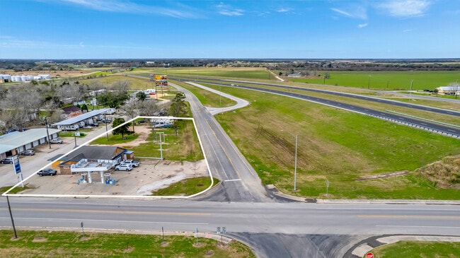

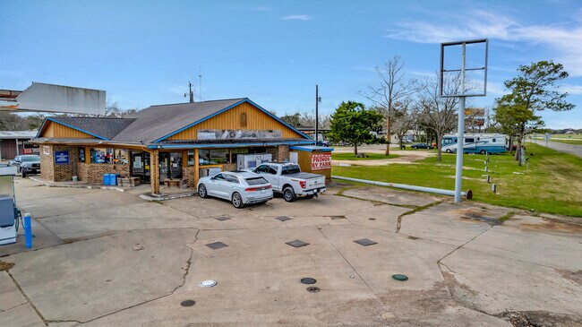
This Property Is For Sale
Property Detail
1100 W Us Highway 59 Feeder
R22040
PHILLIPS, BLOCK 2, LOT PT 7 & PT E PT 6, ACRES 0.243
Commercialnec
JACKSON
B and X Area of moderate flood hazard, usually the area between the limits of the 100-year and 500-year floods.
Texas
2025
0.24 AC
2025
Texas South Area
950100
Other Market Areas
2,051 SF
NEARBY LISTINGS FOR SALE OR LEASE
-
-
View all Ganado listings for sale on LoopNet.com
DEMOGRAPHICS near 1100 W Us Highway 59 Feeder
1 mile
3 mile
5 mile
2025 Total Population
783
1,480
1,942
2030 Population
721
1,364
1,792
Pop Growth 2025-2030
(7.92%)
(7.84%)
(7.72%)
Average Age
40
40
40
2025 Total Households
272
515
676
HH Growth 2025-2030
(8.46%)
(8.35%)
(8.14%)
Median Household Inc
$56,999
$57,758
$57,631
Avg Household Size
2.70
2.70
2.70
2025 Avg HH Vehicles
2.00
2.00
2.00
Median Home Value
$231,250
$233,889
$233,474
Median Year Built
1962
1962
1962
Nearby Places
Map Layers
Map Styles
 Street
 Aerial
Transit
 Traffic
 Biking
Places
Listings with unknown addresses are not visible on the map
- Restaurants
- Banks
- Shops
- Fitness
- Groceries
Nearby Properties
Address
Land Use
TOTAL SIZE
Lot Size
Zoning
Address
Land Use
TOTAL SIZE
Lot Size
Zoning
216,236 SF
13.77 AC
Address
Land Use
TOTAL SIZE
Lot Size
Zoning
12,784 SF
16.27 AC
Address
Land Use
TOTAL SIZE
Lot Size
Zoning
35,178 SF
2.07 AC
Address
Land Use
TOTAL SIZE
Lot Size
Zoning
33,210 SF
44.45 AC
Address
Land Use
TOTAL SIZE
Lot Size
Zoning
21,084 SF
0.60 AC
Address
Land Use
TOTAL SIZE
Lot Size
Zoning
124.88 AC
Address
Land Use
TOTAL SIZE
Lot Size
Zoning
46,492 SF
3.04 AC
Address
Land Use
TOTAL SIZE
Lot Size
Zoning
25,543 SF
2.68 AC
Address
Land Use
TOTAL SIZE
Lot Size
Zoning
1,976 SF
7.50 AC
Address
Land Use
TOTAL SIZE
Lot Size
Zoning
2,169 SF
594.47 AC
Address
Land Use
TOTAL SIZE
Lot Size
Zoning
Address
Land Use
TOTAL SIZE
Lot Size
Zoning
8,000 SF
8.07 AC
Address
Land Use
TOTAL SIZE
Lot Size
Zoning
11,409 SF
0.58 AC
Address
Land Use
TOTAL SIZE
Lot Size
Zoning
18,770 SF
160 AC
Address
Land Use
TOTAL SIZE
Lot Size
Zoning
9,504 SF
1.19 AC
Address
Land Use
TOTAL SIZE
Lot Size
Zoning
3,094 SF
0.83 AC
Address
Land Use
TOTAL SIZE
Lot Size
Zoning
10,984 SF
0.88 AC
Address
Land Use
TOTAL SIZE
Lot Size
Zoning
4,986 SF
30.20 AC
Address
Land Use
TOTAL SIZE
Lot Size
Zoning
14,032 SF
3.85 AC
Address
Land Use
TOTAL SIZE
Lot Size
Zoning
256,294 SF
Address
Land Use
TOTAL SIZE
Lot Size
Zoning
210,210 SF
3 AC
Address
Land Use
TOTAL SIZE
Lot Size
Zoning
11,584 SF
3.97 AC
Address
Land Use
TOTAL SIZE
Lot Size
Zoning
3,168 SF
11.87 AC
Address
Land Use
TOTAL SIZE
Lot Size
Zoning
2,040 SF
2.37 AC
Address
Land Use
TOTAL SIZE
Lot Size
Zoning
3,445 SF
0.45 AC
Address
Land Use
TOTAL SIZE
Lot Size
Zoning
2,419 SF
2.83 AC
Address
Land Use
TOTAL SIZE
Lot Size
Zoning
19,500 SF
1.02 AC
Address
Land Use
TOTAL SIZE
Lot Size
Zoning
240 SF
28.84 AC
Address
Land Use
TOTAL SIZE
Lot Size
Zoning
320 SF
788.83 AC
Address
Land Use
TOTAL SIZE
Lot Size
Zoning
140 SF
21.21 AC
The World's #1 Commercial Real Estate Marketplace
Connect with us
© 2026 CoStar Group
The information above has been obtained from sources believed reliable. While we do not doubt its accuracy we have not verified it and make no guarantee, warranty or representation about it. It is your responsibility to independently confirm its accuracy and completeness. Any projections, opinions, assumptions, or estimates used are for example only and do not represent the current or future performance of the property. The value of this transaction to you depends on tax and other factors which should be evaluated by your tax, financial, and legal advisors. You and your advisors should conduct a careful, independent investigation of the property to determine to your satisfaction the suitability of the property for your needs.