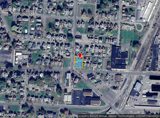
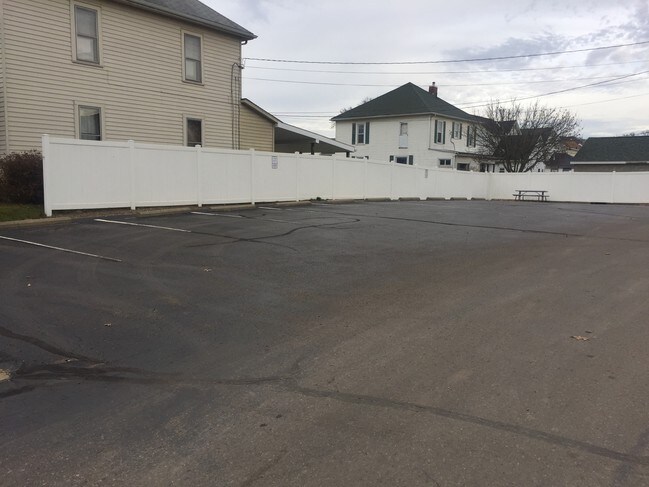
Property Record
1100 Walnut St, Coshocton, OH 43812

NEARBY LISTINGS FOR SALE OR LEASE
Property Detail
1100 Walnut St
04300-000-298-00
Highland Terrace Subdivision
Financialbuilding
EXEMPT DTE #CE0172 PT OUT LOT 147 .2983A
X
Coshocton
39031C0215C
Ohio
2024
147
2024
0.30 AC
961500
Other Market Areas
1,749 SF
Coshocton, OH
DEMOGRAPHICS near 1100 Walnut St
1 Mile
3 Mile
5 Mile
2024 Total Population
8,880
14,369
17,896
2029 Population
8,909
14,398
17,922
Pop Growth 2024-2029
+ 0.33%
+ 0.20%
+ 0.15%
Average Age
40
42
42
2024 Total Households
3,792
6,219
7,592
HH Growth 2024-2029
+ 0.32%
+ 0.21%
+ 0.16%
Median Household Inc
$41,120
$42,271
$44,288
Avg Household Size
2.20
2.20
2.30
2024 Avg HH Vehicles
2.00
2.00
2.00
Median Home Value
$74,171
$91,779
$106,457
Median Year Built
1949
1955
1959
Nearby Places
Map Layers
Map Styles
 Street
 Aerial
- Restaurants
- Banks
- Shops
- Fitness
- Groceries
SALE & LEASE HISTORY
LISTING DATE
SALE/LEASE

Jan 05, 2018
For Sale
Nearby Properties
Address
Land Use
TOTAL SIZE
Lot Size
Zoning
Address
Land Use
TOTAL SIZE
Lot Size
Zoning
792 SF
26.21 AC
Address
Land Use
TOTAL SIZE
Lot Size
Zoning
3.25 AC
Address
Land Use
TOTAL SIZE
Lot Size
Zoning
1.21 AC
Address
Land Use
TOTAL SIZE
Lot Size
Zoning
183,906 SF
31.16 AC
Address
Land Use
TOTAL SIZE
Lot Size
Zoning
11,200 SF
20.80 AC
Address
Land Use
TOTAL SIZE
Lot Size
Zoning
20,990 SF
1.61 AC
Address
Land Use
TOTAL SIZE
Lot Size
Zoning
263,272 SF
30.62 AC
Address
Land Use
TOTAL SIZE
Lot Size
Zoning
9,703 SF
12 AC
Address
Land Use
TOTAL SIZE
Lot Size
Zoning
38.53 AC
Address
Land Use
TOTAL SIZE
Lot Size
Zoning
20.13 AC
Address
Land Use
TOTAL SIZE
Lot Size
Zoning
4,014 SF
34.92 AC
Address
Land Use
TOTAL SIZE
Lot Size
Zoning
48,185 SF
1.36 AC
Address
Land Use
TOTAL SIZE
Lot Size
Zoning
2,693 SF
37.51 AC
Address
Land Use
TOTAL SIZE
Lot Size
Zoning
3,055 SF
11.15 AC
Address
Land Use
TOTAL SIZE
Lot Size
Zoning
37.85 AC
Address
Land Use
TOTAL SIZE
Lot Size
Zoning
32,896 SF
0.15 AC
Address
Land Use
TOTAL SIZE
Lot Size
Zoning
38,997 SF
4.11 AC
Address
Land Use
TOTAL SIZE
Lot Size
Zoning
52,736 SF
17.14 AC
Address
Land Use
TOTAL SIZE
Lot Size
Zoning
74,740 SF
0.11 AC
Address
Land Use
TOTAL SIZE
Lot Size
Zoning
7,684 SF
2.76 AC
Address
Land Use
TOTAL SIZE
Lot Size
Zoning
Address
Land Use
TOTAL SIZE
Lot Size
Zoning
2,940 SF
3.56 AC
Address
Land Use
TOTAL SIZE
Lot Size
Zoning
7,872 SF
0.27 AC
Address
Land Use
TOTAL SIZE
Lot Size
Zoning
162,786 SF
9.17 AC
Address
Land Use
TOTAL SIZE
Lot Size
Zoning
33,952 SF
7.63 AC
Address
Land Use
TOTAL SIZE
Lot Size
Zoning
35,704 SF
45.78 AC
Address
Land Use
TOTAL SIZE
Lot Size
Zoning
30.62 AC
Address
Land Use
TOTAL SIZE
Lot Size
Zoning
69,604 SF
21.09 AC
Address
Land Use
TOTAL SIZE
Lot Size
Zoning
422.83 AC
Address
Land Use
TOTAL SIZE
Lot Size
Zoning
0.72 AC
The World's #1 Commercial Real Estate Marketplace
Connect with us
© 2026 CoStar Group
The information above has been obtained from sources believed reliable. While we do not doubt its accuracy we have not verified it and make no guarantee, warranty or representation about it. It is your responsibility to independently confirm its accuracy and completeness. Any projections, opinions, assumptions, or estimates used are for example only and do not represent the current or future performance of the property. The value of this transaction to you depends on tax and other factors which should be evaluated by your tax, financial, and legal advisors. You and your advisors should conduct a careful, independent investigation of the property to determine to your satisfaction the suitability of the property for your needs.