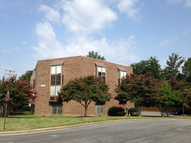
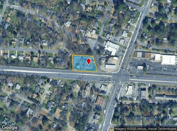
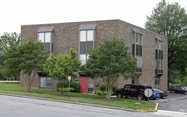
Property Record
1100 Welborne Dr, Henrico, VA 23229
Current Lease Availabilities
NEARBY LISTINGS FOR SALE OR LEASE
Property Detail
1100 Welborne Dr
753-741-0358
01000A0000 0056; WL WELBORNE DR AC .904 84 A1 27
Officebuilding
Henrico
X
Virginia
5101290005E
0.90 AC
2025
Parham South
2025
Richmond VA
200106
Richmond, VA
16,617 SF
DEMOGRAPHICS near 1100 Welborne Dr
1 Mile
3 Mile
5 Mile
2024 Total Population
12,318
76,200
196,151
2029 Population
12,340
75,987
197,179
Pop Growth 2024-2029
+ 0.18%
(0.28%)
+ 0.52%
Average Age
39
40
41
2024 Total Households
4,769
30,524
81,108
HH Growth 2024-2029
+ 0.13%
(0.35%)
+ 0.52%
Median Household Inc
$74,009
$90,596
$91,270
Avg Household Size
2.50
2.30
2.30
2024 Avg HH Vehicles
2.00
2.00
2.00
Median Home Value
$339,593
$392,312
$370,202
Median Year Built
1963
1975
1979
Nearby Places
Map Layers
Map Styles
 Street
 Aerial
- Restaurants
- Banks
- Shops
- Fitness
- Groceries
PUBLIC TRANSPORTATION
COMMUTER RAIL
Richmond Staples Mill Road Amtrak Station (Carolinian - Amtrak, Northeast Regional - Amtrak, Palmetto - Amtrak, Silver Meteor - Amtrak)
DRIVE
WALK
Distance
Richmond Staples Mill Road Amtrak Station (Carolinian - Amtrak, Northeast Regional - Amtrak, Palmetto - Amtrak, Silver Meteor - Amtrak)
10 min
5.0 mi
AIRPORT
Richmond International
DRIVE
WALK
Distance
Richmond International
30 min
19.1 mi
Freight Ports
Virginia Port Authority - Richmond
DRIVE
WALK
Distance
Virginia Port Authority - Richmond
28 min
17.4 mi
Nearby Properties
Address
Land Use
TOTAL SIZE
Lot Size
Zoning
Address
Land Use
TOTAL SIZE
Lot Size
Zoning
632,549 SF
90.12 AC
R-6
Address
Land Use
TOTAL SIZE
Lot Size
Zoning
585,792 SF
38.94 AC
R-5
Address
Land Use
TOTAL SIZE
Lot Size
Zoning
568,334 SF
26.13 AC
MIXE
Address
Land Use
TOTAL SIZE
Lot Size
Zoning
577,728 SF
34.86 AC
R-5
Address
Land Use
TOTAL SIZE
Lot Size
Zoning
527,410 SF
40.70 AC
A-1
Address
Land Use
TOTAL SIZE
Lot Size
Zoning
34,065 SF
33.21 AC
R-1
Address
Land Use
TOTAL SIZE
Lot Size
Zoning
184,760 SF
51.60 AC
A-1
Address
Land Use
TOTAL SIZE
Lot Size
Zoning
26.88 AC
MULTIPLE Z
Address
Land Use
TOTAL SIZE
Lot Size
Zoning
309,500 SF
29.78 AC
MIXE
Address
Land Use
TOTAL SIZE
Lot Size
Zoning
344,965 SF
28.33 AC
MIXE
Address
Land Use
TOTAL SIZE
Lot Size
Zoning
271,060 SF
18.31 AC
R-6
Address
Land Use
TOTAL SIZE
Lot Size
Zoning
268,461 SF
17.09 AC
R-5
Address
Land Use
TOTAL SIZE
Lot Size
Zoning
311,196 SF
27.62 AC
R-5
Address
Land Use
TOTAL SIZE
Lot Size
Zoning
2.51 AC
UMUC
Address
Land Use
TOTAL SIZE
Lot Size
Zoning
250,146 SF
20.41 AC
R-5
Address
Land Use
TOTAL SIZE
Lot Size
Zoning
296,784 SF
23.11 AC
R-5
Address
Land Use
TOTAL SIZE
Lot Size
Zoning
182,188 SF
21.84 AC
R-5
Address
Land Use
TOTAL SIZE
Lot Size
Zoning
257,130 SF
33.65 AC
B-3
Address
Land Use
TOTAL SIZE
Lot Size
Zoning
320,000 SF
0.61 AC
I INSTITUT
Address
Land Use
TOTAL SIZE
Lot Size
Zoning
500,400 SF
31.15 AC
R-5
Address
Land Use
TOTAL SIZE
Lot Size
Zoning
232,368 SF
26.11 AC
R-5
Address
Land Use
TOTAL SIZE
Lot Size
Zoning
174,500 SF
8.57 AC
O-3
Address
Land Use
TOTAL SIZE
Lot Size
Zoning
60,000 SF
27 AC
R-4 SINGLE
Address
Land Use
TOTAL SIZE
Lot Size
Zoning
371,568 SF
21.19 AC
R-5
Address
Land Use
TOTAL SIZE
Lot Size
Zoning
413,600 SF
36.28 AC
R-5
Address
Land Use
TOTAL SIZE
Lot Size
Zoning
1,456 SF
11.71 AC
R-5
Address
Land Use
TOTAL SIZE
Lot Size
Zoning
220,895 SF
77.14 AC
A-1
Address
Land Use
TOTAL SIZE
Lot Size
Zoning
167,576 SF
14.29 AC
R-5
Address
Land Use
TOTAL SIZE
Lot Size
Zoning
191,826 SF
2.64 AC
I INSTITUT
Address
Land Use
TOTAL SIZE
Lot Size
Zoning
57,357 SF
139.18 AC
R-1 SINGLE
The World's #1 Commercial Real Estate Marketplace
Connect with us
© 2025 CoStar Group
The information above has been obtained from sources believed reliable. While we do not doubt its accuracy we have not verified it and make no guarantee, warranty or representation about it. It is your responsibility to independently confirm its accuracy and completeness. Any projections, opinions, assumptions, or estimates used are for example only and do not represent the current or future performance of the property. The value of this transaction to you depends on tax and other factors which should be evaluated by your tax, financial, and legal advisors. You and your advisors should conduct a careful, independent investigation of the property to determine to your satisfaction the suitability of the property for your needs.