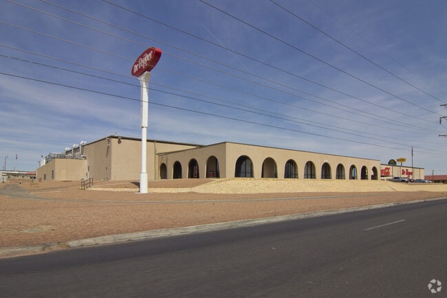
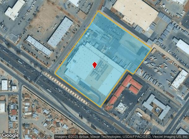
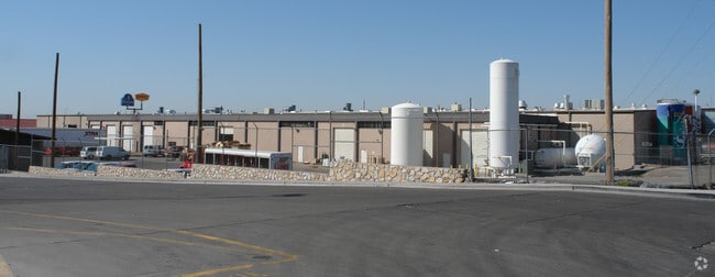
Property Record
11001 Gateway Blvd W, El Paso, TX 79935
NEARBY LISTINGS FOR SALE OR LEASE
Property Detail
11001 Gateway Blvd W
V893-999-0130-0100
Vista Del Sol
Industrialgeneral
13 VISTA DEL SOL #5 1 & 2 & 3 OF BLK 13 VISTA DEL SOL #7 (12.0296 AC)
X
El Paso
4802140045C
Texas
2024
12.03 AC
2025
East
004312
El Paso
198,136 SF
El Paso, TX
DEMOGRAPHICS near 11001 Gateway Blvd W
1 Mile
3 Mile
5 Mile
2024 Total Population
9,860
124,410
264,469
2029 Population
9,951
125,413
266,076
Pop Growth 2024-2029
+ 0.92%
+ 0.81%
+ 0.61%
Average Age
40
40
38
2024 Total Households
3,809
46,492
94,179
HH Growth 2024-2029
+ 1.02%
+ 0.80%
+ 0.63%
Median Household Inc
$38,952
$46,292
$50,164
Avg Household Size
2.50
2.60
2.80
2024 Avg HH Vehicles
2.00
2.00
2.00
Median Home Value
$145,462
$145,661
$147,855
Median Year Built
1972
1976
1981
Nearby Places
Map Layers
Map Styles
 Street
 Aerial
- Restaurants
- Banks
- Shops
- Fitness
- Groceries
PUBLIC TRANSPORTATION
AIRPORT
El Paso International
DRIVE
WALK
Distance
El Paso International
19 min
8.3 mi
Nearby Properties
Address
Land Use
TOTAL SIZE
Lot Size
Zoning
Address
Land Use
TOTAL SIZE
Lot Size
Zoning
600,211 SF
114.73 AC
RF
Address
Land Use
TOTAL SIZE
Lot Size
Zoning
1,122,782 SF
55.24 AC
C4
Address
Land Use
TOTAL SIZE
Lot Size
Zoning
1 SF
M1
Address
Land Use
TOTAL SIZE
Lot Size
Zoning
380,811 SF
22.75 AC
M1
Address
Land Use
TOTAL SIZE
Lot Size
Zoning
1 SF
Address
Land Use
TOTAL SIZE
Lot Size
Zoning
377,168 SF
8.40 AC
C1
Address
Land Use
TOTAL SIZE
Lot Size
Zoning
80,049 SF
8.90 AC
C4
Address
Land Use
TOTAL SIZE
Lot Size
Zoning
235,670 SF
10 AC
A3C
Address
Land Use
TOTAL SIZE
Lot Size
Zoning
118,114 SF
13.80 AC
C4S
Address
Land Use
TOTAL SIZE
Lot Size
Zoning
202,253 SF
10.70 AC
A2
Address
Land Use
TOTAL SIZE
Lot Size
Zoning
166,671 SF
24.61 AC
C4S
Address
Land Use
TOTAL SIZE
Lot Size
Zoning
125,896 SF
8.67 AC
R3
Address
Land Use
TOTAL SIZE
Lot Size
Zoning
209,006 SF
18.18 AC
C4
Address
Land Use
TOTAL SIZE
Lot Size
Zoning
230,152 SF
14.09 AC
C4S
Address
Land Use
TOTAL SIZE
Lot Size
Zoning
192,261 SF
8.07 AC
A3C
Address
Land Use
TOTAL SIZE
Lot Size
Zoning
106,261 SF
3 AC
R3
Address
Land Use
TOTAL SIZE
Lot Size
Zoning
206,726 SF
24.42 AC
M1S
Address
Land Use
TOTAL SIZE
Lot Size
Zoning
154,016 SF
8.05 AC
A2
Address
Land Use
TOTAL SIZE
Lot Size
Zoning
111,558 SF
16.25 AC
C4
Address
Land Use
TOTAL SIZE
Lot Size
Zoning
272,601 SF
14.97 AC
AO
Address
Land Use
TOTAL SIZE
Lot Size
Zoning
259,968 SF
10.54 AC
AO
Address
Land Use
TOTAL SIZE
Lot Size
Zoning
269,974 SF
15.87 AC
A2S
Address
Land Use
TOTAL SIZE
Lot Size
Zoning
235,213 SF
11.98 AC
A3O
Address
Land Use
TOTAL SIZE
Lot Size
Zoning
377,504 SF
24.32 AC
C4S
Address
Land Use
TOTAL SIZE
Lot Size
Zoning
170,528 SF
9.05 AC
C3S
Address
Land Use
TOTAL SIZE
Lot Size
Zoning
197,105 SF
15.41 AC
C4S
Address
Land Use
TOTAL SIZE
Lot Size
Zoning
63,058 SF
21.40 AC
C4
Address
Land Use
TOTAL SIZE
Lot Size
Zoning
109,578 SF
17.84 AC
RF
Address
Land Use
TOTAL SIZE
Lot Size
Zoning
186,950 SF
14.30 AC
C1
Address
Land Use
TOTAL SIZE
Lot Size
Zoning
144,211 SF
17.20 AC
C4
The World's #1 Commercial Real Estate Marketplace
Connect with us
© 2026 CoStar Group
The information above has been obtained from sources believed reliable. While we do not doubt its accuracy we have not verified it and make no guarantee, warranty or representation about it. It is your responsibility to independently confirm its accuracy and completeness. Any projections, opinions, assumptions, or estimates used are for example only and do not represent the current or future performance of the property. The value of this transaction to you depends on tax and other factors which should be evaluated by your tax, financial, and legal advisors. You and your advisors should conduct a careful, independent investigation of the property to determine to your satisfaction the suitability of the property for your needs.