Property Record
11005 N Oracle Rd, Tucson, AZ 85737


Current Lease Availabilities
NEARBY LISTINGS FOR SALE OR LEASE
Property Detail
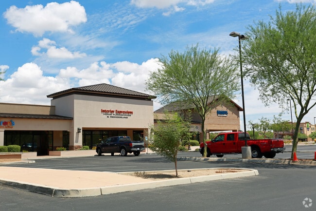
11005 N Oracle Rd
Tucson, AZ
Steam Pump Village Retail
220-08-4520
STEAM PUMP VILLAGE RETAIL CENTER LOT 1
Stripcommercialcenter
Pima
X
Arizona
04019C1089L
1
2025
2.95 AC
2025
North/Oro Valley
004642
Tucson
17,787 SF
DEMOGRAPHICS near 11005 N Oracle Rd
1 Mile
3 Mile
5 Mile
2024 Total Population
4,314
26,664
64,292
2029 Population
4,548
27,764
67,205
Pop Growth 2024-2029
+ 5.42%
+ 4.13%
+ 4.53%
Average Age
49
48
49
2024 Total Households
2,213
11,903
28,088
HH Growth 2024-2029
+ 5.20%
+ 4.16%
+ 4.61%
Median Household Inc
$91,022
$94,877
$97,997
Avg Household Size
1.90
2.20
2.20
2024 Avg HH Vehicles
2.00
2.00
2.00
Median Home Value
$392,856
$373,341
$387,052
Median Year Built
1996
1995
1994
Nearby Places
Map Layers
Map Styles
 Street
 Aerial
- Restaurants
- Banks
- Shops
- Fitness
- Groceries
PUBLIC TRANSPORTATION
AIRPORT
Tucson International
DRIVE
WALK
Distance
Tucson International
40 min
22.4 mi
Freight Ports
Port of San Diego
DRIVE
WALK
Distance
Port of San Diego
436 min
405.4 mi
Nearby Properties
Address
Land Use
TOTAL SIZE
Lot Size
Zoning
Address
Land Use
TOTAL SIZE
Lot Size
Zoning
372,926 SF
58.86 AC
CPI
Address
Land Use
TOTAL SIZE
Lot Size
Zoning
231,366 SF
34.15 AC
PAD
Address
Land Use
TOTAL SIZE
Lot Size
Zoning
26,560 SF
9.02 AC
PAD
Address
Land Use
TOTAL SIZE
Lot Size
Zoning
362,401 SF
19.55 AC
PAD
Address
Land Use
TOTAL SIZE
Lot Size
Zoning
272,429 SF
36.97 AC
R1144
Address
Land Use
TOTAL SIZE
Lot Size
Zoning
5.40 AC
PAD
Address
Land Use
TOTAL SIZE
Lot Size
Zoning
Address
Land Use
TOTAL SIZE
Lot Size
Zoning
321,810 SF
15.73 AC
Address
Land Use
TOTAL SIZE
Lot Size
Zoning
187,045 SF
16.70 AC
PAD
Address
Land Use
TOTAL SIZE
Lot Size
Zoning
352,158 SF
15.89 AC
Address
Land Use
TOTAL SIZE
Lot Size
Zoning
89,041 SF
35.51 AC
Address
Land Use
TOTAL SIZE
Lot Size
Zoning
214,008 SF
9.20 AC
Address
Land Use
TOTAL SIZE
Lot Size
Zoning
194,629 SF
17.47 AC
PAD
Address
Land Use
TOTAL SIZE
Lot Size
Zoning
136,060 SF
13.36 AC
R1144
Address
Land Use
TOTAL SIZE
Lot Size
Zoning
206,109 SF
7.12 AC
PAD
Address
Land Use
TOTAL SIZE
Lot Size
Zoning
9,240 SF
17.07 AC
PAD
Address
Land Use
TOTAL SIZE
Lot Size
Zoning
288,545 SF
13.03 AC
Address
Land Use
TOTAL SIZE
Lot Size
Zoning
27,464 SF
4.63 AC
PAD
Address
Land Use
TOTAL SIZE
Lot Size
Zoning
69,865 SF
0.84 AC
PAD
Address
Land Use
TOTAL SIZE
Lot Size
Zoning
109,279 SF
11.54 AC
PAD
Address
Land Use
TOTAL SIZE
Lot Size
Zoning
343,624 SF
27.10 AC
Address
Land Use
TOTAL SIZE
Lot Size
Zoning
3,598 SF
1.87 AC
PAD
Address
Land Use
TOTAL SIZE
Lot Size
Zoning
103,699 SF
4.34 AC
R4
Address
Land Use
TOTAL SIZE
Lot Size
Zoning
2.83 AC
PAD
Address
Land Use
TOTAL SIZE
Lot Size
Zoning
59,868 SF
8.91 AC
PSC
Address
Land Use
TOTAL SIZE
Lot Size
Zoning
152,223 SF
8.72 AC
PAD
Address
Land Use
TOTAL SIZE
Lot Size
Zoning
130,481 SF
10.69 AC
PAD
Address
Land Use
TOTAL SIZE
Lot Size
Zoning
62,040 SF
9.47 AC
PAD
Address
Land Use
TOTAL SIZE
Lot Size
Zoning
45,000 SF
8.50 AC
C1
Address
Land Use
TOTAL SIZE
Lot Size
Zoning
109,408 SF
5.71 AC
R1144
The World's #1 Commercial Real Estate Marketplace
Connect with us
© 2026 CoStar Group
The information above has been obtained from sources believed reliable. While we do not doubt its accuracy we have not verified it and make no guarantee, warranty or representation about it. It is your responsibility to independently confirm its accuracy and completeness. Any projections, opinions, assumptions, or estimates used are for example only and do not represent the current or future performance of the property. The value of this transaction to you depends on tax and other factors which should be evaluated by your tax, financial, and legal advisors. You and your advisors should conduct a careful, independent investigation of the property to determine to your satisfaction the suitability of the property for your needs.