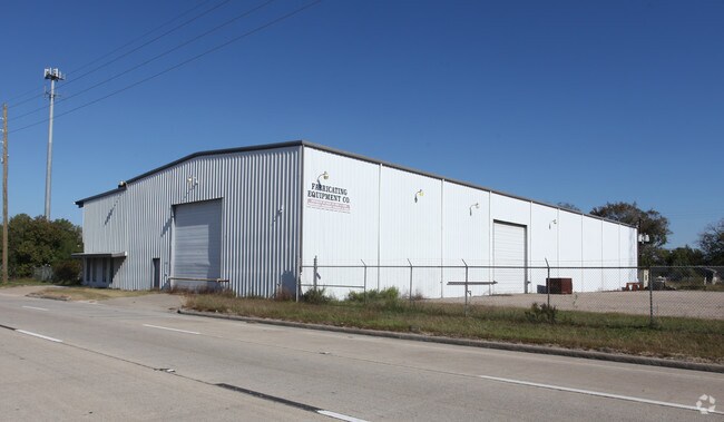
Property Record
11006 E Sam Houston Pkwy N, Houston, TX 77044

NEARBY LISTINGS FOR SALE OR LEASE
Property Detail
11006 E Sam Houston Pkwy N
Houston-The Woodlands-Sugar Land, TX
Meadowlake Tract A
0961030000105
LT 105 MEADOWLAKE TRACT A
Commercialacreage
Harris
X
Texas
48201C0705M
105
2024
0.28 AC
2025
Northeast Hwy 90
252002
Houston
DEMOGRAPHICS near 11006 E Sam Houston Pkwy N
1 Mile
3 Mile
5 Mile
2024 Total Population
4,626
36,313
105,770
2029 Population
4,723
37,393
109,155
Pop Growth 2024-2029
+ 2.10%
+ 2.97%
+ 3.20%
Average Age
30
31
33
2024 Total Households
1,373
10,350
32,134
HH Growth 2024-2029
+ 2.11%
+ 2.93%
+ 3.17%
Median Household Inc
$58,930
$56,225
$61,949
Avg Household Size
3.30
3.40
3.20
2024 Avg HH Vehicles
2.00
2.00
2.00
Median Home Value
$156,171
$159,068
$188,668
Median Year Built
2010
2005
2003
Nearby Places
Map Layers
Map Styles
 Street
 Aerial
- Restaurants
- Banks
- Shops
- Fitness
- Groceries
PUBLIC TRANSPORTATION
AIRPORT
George Bush Intcntl/Houston
DRIVE
WALK
Distance
George Bush Intcntl/Houston
19 min
15.1 mi
William P Hobby
DRIVE
WALK
Distance
William P Hobby
39 min
22.9 mi
Freight Ports
Port of Houston
DRIVE
WALK
Distance
Port of Houston
25 min
14.9 mi
SALE & LEASE HISTORY
LISTING DATE
SALE/LEASE

Jul 10, 2019
For Sale
Nearby Properties
Address
Land Use
TOTAL SIZE
Lot Size
Zoning
Address
Land Use
TOTAL SIZE
Lot Size
Zoning
1,421,980 SF
147.83 AC
Address
Land Use
TOTAL SIZE
Lot Size
Zoning
1,036,748 SF
72.42 AC
Address
Land Use
TOTAL SIZE
Lot Size
Zoning
642,163 SF
37.07 AC
Address
Land Use
TOTAL SIZE
Lot Size
Zoning
1,793.99 AC
Address
Land Use
TOTAL SIZE
Lot Size
Zoning
277,486 SF
15.42 AC
Address
Land Use
TOTAL SIZE
Lot Size
Zoning
315,000 SF
21.47 AC
Address
Land Use
TOTAL SIZE
Lot Size
Zoning
212,558 SF
52.87 AC
Address
Land Use
TOTAL SIZE
Lot Size
Zoning
824,156 SF
53.31 AC
Address
Land Use
TOTAL SIZE
Lot Size
Zoning
168,348 SF
108.41 AC
Address
Land Use
TOTAL SIZE
Lot Size
Zoning
260,630 SF
15.16 AC
Address
Land Use
TOTAL SIZE
Lot Size
Zoning
214,100 SF
11.32 AC
Address
Land Use
TOTAL SIZE
Lot Size
Zoning
260,792 SF
206.39 AC
Address
Land Use
TOTAL SIZE
Lot Size
Zoning
80,653 SF
60.20 AC
Address
Land Use
TOTAL SIZE
Lot Size
Zoning
198,306 SF
8.41 AC
Address
Land Use
TOTAL SIZE
Lot Size
Zoning
131,500 SF
6.22 AC
Address
Land Use
TOTAL SIZE
Lot Size
Zoning
210.19 AC
Address
Land Use
TOTAL SIZE
Lot Size
Zoning
125,272 SF
16.68 AC
Address
Land Use
TOTAL SIZE
Lot Size
Zoning
264,022 SF
12.81 AC
Address
Land Use
TOTAL SIZE
Lot Size
Zoning
239,419 SF
33 AC
Address
Land Use
TOTAL SIZE
Lot Size
Zoning
319,238 SF
44.48 AC
Address
Land Use
TOTAL SIZE
Lot Size
Zoning
4,720 SF
25 AC
Address
Land Use
TOTAL SIZE
Lot Size
Zoning
98,733 SF
7.94 AC
Address
Land Use
TOTAL SIZE
Lot Size
Zoning
171.95 AC
Address
Land Use
TOTAL SIZE
Lot Size
Zoning
128,496 SF
10.19 AC
Address
Land Use
TOTAL SIZE
Lot Size
Zoning
79.45 AC
Address
Land Use
TOTAL SIZE
Lot Size
Zoning
23,840 SF
103.67 AC
Address
Land Use
TOTAL SIZE
Lot Size
Zoning
117,580 SF
5.16 AC
Address
Land Use
TOTAL SIZE
Lot Size
Zoning
90,645 SF
42.60 AC
Address
Land Use
TOTAL SIZE
Lot Size
Zoning
83,695 SF
17.55 AC
Address
Land Use
TOTAL SIZE
Lot Size
Zoning
56,810 SF
10 AC
The World's #1 Commercial Real Estate Marketplace
Connect with us
© 2025 CoStar Group
The information above has been obtained from sources believed reliable. While we do not doubt its accuracy we have not verified it and make no guarantee, warranty or representation about it. It is your responsibility to independently confirm its accuracy and completeness. Any projections, opinions, assumptions, or estimates used are for example only and do not represent the current or future performance of the property. The value of this transaction to you depends on tax and other factors which should be evaluated by your tax, financial, and legal advisors. You and your advisors should conduct a careful, independent investigation of the property to determine to your satisfaction the suitability of the property for your needs.