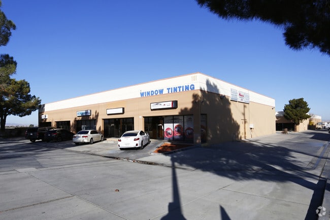
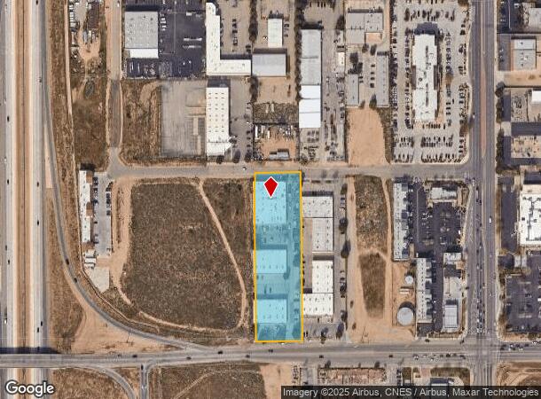
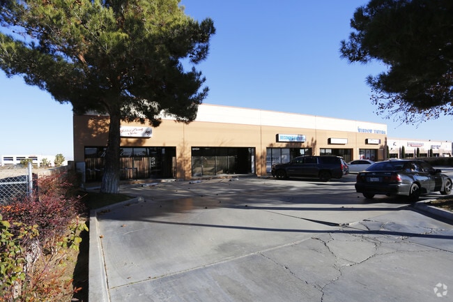
Property Record
1101 W Columbia Way, Lancaster, CA 93534
Current Lease Availabilities
NEARBY LISTINGS FOR SALE OR LEASE
Property Detail
1101 W Columbia Way
Los Angeles-Long Beach-Glendale, CA
Ls65-23
3109-023-046
R S 65-23-26 E 1/2 (EX OF ST) OF LOT 115
Warehouse
Los Angeles
X
California
06037C0420F
115
2024
2.36 AC
2025
Antelope Valley
900705
Los Angeles
93,678 SF
DEMOGRAPHICS near 1101 W Columbia Way
1 Mile
3 Mile
5 Mile
2024 Total Population
384
51,193
205,332
2029 Population
367
49,955
198,822
Pop Growth 2024-2029
(4.43%)
(2.42%)
(3.17%)
Average Age
42
38
37
2024 Total Households
137
18,082
64,870
HH Growth 2024-2029
(4.38%)
(2.63%)
(3.38%)
Median Household Inc
$59,482
$63,164
$68,283
Avg Household Size
2.70
2.70
3.10
2024 Avg HH Vehicles
2.00
2.00
2.00
Median Home Value
$454,166
$383,002
$356,699
Median Year Built
1975
1983
1985
Nearby Places
Map Layers
Map Styles
 Street
 Aerial
- Restaurants
- Banks
- Shops
- Fitness
- Groceries
PUBLIC TRANSPORTATION
COMMUTER RAIL
Lancaster (Antelope Valley Line - Southern California Regional Rail Authority (Metrolink))
DRIVE
WALK
Distance
Lancaster (Antelope Valley Line - Southern California Regional Rail Authority (Metrolink))
7 min
4.3 mi
Palmdale (Antelope Valley Line - Southern California Regional Rail Authority (Metrolink))
DRIVE
WALK
Distance
Palmdale (Antelope Valley Line - Southern California Regional Rail Authority (Metrolink))
9 min
5.7 mi
Freight Ports
Port of Long Beach
DRIVE
WALK
Distance
Port of Long Beach
105 min
90.2 mi
Nearby Properties
Address
Land Use
TOTAL SIZE
Lot Size
Zoning
Address
Land Use
TOTAL SIZE
Lot Size
Zoning
2,861,890 SF
528.69 AC
POMA-A25*
Address
Land Use
TOTAL SIZE
Lot Size
Zoning
449,135 SF
29.76 AC
PDRA
Address
Land Use
TOTAL SIZE
Lot Size
Zoning
133,783 SF
48.02 AC
LRLI
Address
Land Use
TOTAL SIZE
Lot Size
Zoning
234,378 SF
15.25 AC
Address
Land Use
TOTAL SIZE
Lot Size
Zoning
143,852 SF
8.58 AC
LRHDR*
Address
Land Use
TOTAL SIZE
Lot Size
Zoning
160,028 SF
10.81 AC
LRMDR*
Address
Land Use
TOTAL SIZE
Lot Size
Zoning
179,304 SF
12.43 AC
LRMDR*
Address
Land Use
TOTAL SIZE
Lot Size
Zoning
126,102 SF
8.57 AC
LRRA7000*
Address
Land Use
TOTAL SIZE
Lot Size
Zoning
201,615 SF
20.60 AC
PDC4
Address
Land Use
TOTAL SIZE
Lot Size
Zoning
129,896 SF
9.10 AC
LRRPD70001
Address
Land Use
TOTAL SIZE
Lot Size
Zoning
74,213 SF
4.46 AC
LRA17000*
Address
Land Use
TOTAL SIZE
Lot Size
Zoning
185,527 SF
9.65 AC
LRR325U*
Address
Land Use
TOTAL SIZE
Lot Size
Zoning
66,526 SF
9.12 AC
LAWC
Address
Land Use
TOTAL SIZE
Lot Size
Zoning
60,113 SF
2.03 AC
LRCPD
Address
Land Use
TOTAL SIZE
Lot Size
Zoning
123,924 SF
19.01 AC
LRA22*
Address
Land Use
TOTAL SIZE
Lot Size
Zoning
166,272 SF
8.71 AC
LRRA7000*
Address
Land Use
TOTAL SIZE
Lot Size
Zoning
132,584 SF
8.66 AC
LRMDR*
Address
Land Use
TOTAL SIZE
Lot Size
Zoning
170,697 SF
9.29 AC
LRRPD12U*
Address
Land Use
TOTAL SIZE
Lot Size
Zoning
90,429 SF
4.59 AC
LRHDR*
Address
Land Use
TOTAL SIZE
Lot Size
Zoning
90,429 SF
4.38 AC
LRHDR*
Address
Land Use
TOTAL SIZE
Lot Size
Zoning
57,382 SF
2.52 AC
PDC4*
Address
Land Use
TOTAL SIZE
Lot Size
Zoning
97,566 SF
8.81 AC
LRC3*
Address
Land Use
TOTAL SIZE
Lot Size
Zoning
101,136 SF
4.18 AC
LRSP
Address
Land Use
TOTAL SIZE
Lot Size
Zoning
107,924 SF
8.95 AC
LRRPD10000
Address
Land Use
TOTAL SIZE
Lot Size
Zoning
127,975 SF
4.77 AC
LRC3DP*
Address
Land Use
TOTAL SIZE
Lot Size
Zoning
147,297 SF
10.57 AC
POC4
Address
Land Use
TOTAL SIZE
Lot Size
Zoning
183,296 SF
11.75 AC
LRRPD25U*
Address
Land Use
TOTAL SIZE
Lot Size
Zoning
68,943 SF
2.72 AC
POC4
Address
Land Use
TOTAL SIZE
Lot Size
Zoning
81,606 SF
3.55 AC
LRSP80-02*
Address
Land Use
TOTAL SIZE
Lot Size
Zoning
103,824 SF
3.58 AC
LRSP80-02*
The World's #1 Commercial Real Estate Marketplace
Connect with us
© 2026 CoStar Group
The information above has been obtained from sources believed reliable. While we do not doubt its accuracy we have not verified it and make no guarantee, warranty or representation about it. It is your responsibility to independently confirm its accuracy and completeness. Any projections, opinions, assumptions, or estimates used are for example only and do not represent the current or future performance of the property. The value of this transaction to you depends on tax and other factors which should be evaluated by your tax, financial, and legal advisors. You and your advisors should conduct a careful, independent investigation of the property to determine to your satisfaction the suitability of the property for your needs.