Property Record
1101 E Main St, Graham, NC 27253
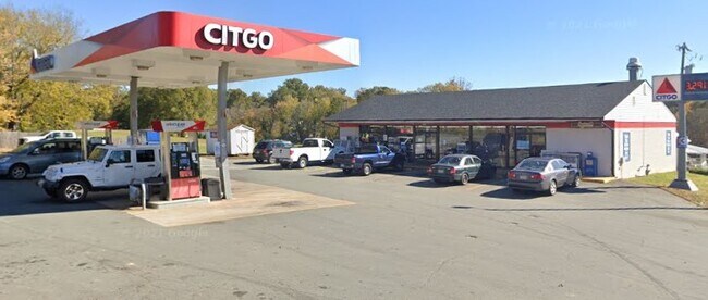

Property Detail
1101 E Main St
Burlington, NC
DESIGNATED AS LOT A LTS 68 & 69 9-1-124
151482
Alamance
Conveniencestore
North Carolina
B and X Area of moderate flood hazard, usually the area between the limits of the 100-year and 500-year floods.
a,68-69
2025
0.90 AC
2025
SE Alamance County
022001
Greensboro/Winston-Salem
2,448 SF
NEARBY LISTINGS FOR SALE OR LEASE
DEMOGRAPHICS near 1101 E Main St
1 mile
3 mile
5 mile
2025 Total Population
1,781
15,860
47,001
2030 Population
1,877
16,900
49,772
Pop Growth 2025-2030
+ 5.39%
+ 6.56%
+ 5.90%
Average Age
44
42
41
2025 Total Households
712
6,437
19,104
HH Growth 2025-2030
+ 5.48%
+ 6.66%
+ 6.04%
Median Household Inc
$88,214
$75,436
$66,875
Avg Household Size
2.50
2.40
2.40
2025 Avg HH Vehicles
3.00
2.00
2.00
Median Home Value
$312,403
$295,065
$275,408
Median Year Built
1978
1992
1991
Nearby Places
Map Layers
Map Styles
 Street
 Aerial
Transit
 Traffic
 Biking
Places
Listings with unknown addresses are not visible on the map
- Restaurants
- Banks
- Shops
- Fitness
- Groceries
PUBLIC TRANSPORTATION
COMMUTER RAIL
Burlington Station (Piedmont - North Carolina by Train (NC Train))
Drive
Walk
Distance
Burlington Station (Piedmont - North Carolina by Train (NC Train))
13 min
7.3 mi
Freight Ports
Virginia Port Authority - Richmond
Drive
Walk
Distance
Virginia Port Authority - Richmond
201 min
173.8 mi
Nearby Properties
Address
Land Use
TOTAL SIZE
Lot Size
Zoning
Address
Land Use
TOTAL SIZE
Lot Size
Zoning
22,500 SF
100.73 AC
Address
Land Use
TOTAL SIZE
Lot Size
Zoning
919,840 SF
85.58 AC
Address
Land Use
TOTAL SIZE
Lot Size
Zoning
333,775 SF
46.14 AC
Address
Land Use
TOTAL SIZE
Lot Size
Zoning
296,940 SF
33.78 AC
Address
Land Use
TOTAL SIZE
Lot Size
Zoning
10,368 SF
11.35 AC
R MF
Address
Land Use
TOTAL SIZE
Lot Size
Zoning
5,246 SF
89.50 AC
Address
Land Use
TOTAL SIZE
Lot Size
Zoning
296,940 SF
36 AC
Address
Land Use
TOTAL SIZE
Lot Size
Zoning
31,920 SF
4.59 AC
R MF
Address
Land Use
TOTAL SIZE
Lot Size
Zoning
7,192 SF
14.08 AC
RMF
Address
Land Use
TOTAL SIZE
Lot Size
Zoning
20,000 SF
8.48 AC
B 2
Address
Land Use
TOTAL SIZE
Lot Size
Zoning
3,600 SF
6.80 AC
R 18
Address
Land Use
TOTAL SIZE
Lot Size
Zoning
177,340 SF
19.50 AC
Address
Land Use
TOTAL SIZE
Lot Size
Zoning
44,736 SF
14.17 AC
R 12
Address
Land Use
TOTAL SIZE
Lot Size
Zoning
6,468 SF
17.42 AC
Address
Land Use
TOTAL SIZE
Lot Size
Zoning
2,724 SF
26.50 AC
Address
Land Use
TOTAL SIZE
Lot Size
Zoning
22,768 SF
17.73 AC
Address
Land Use
TOTAL SIZE
Lot Size
Zoning
4,572 SF
189.40 AC
Address
Land Use
TOTAL SIZE
Lot Size
Zoning
7,986 SF
2.18 AC
R MF
Address
Land Use
TOTAL SIZE
Lot Size
Zoning
21,000 SF
2.56 AC
B2
Address
Land Use
TOTAL SIZE
Lot Size
Zoning
10,068 SF
10.57 AC
R 18
Address
Land Use
TOTAL SIZE
Lot Size
Zoning
76,176 SF
20.83 AC
Address
Land Use
TOTAL SIZE
Lot Size
Zoning
164,942 SF
17.81 AC
Address
Land Use
TOTAL SIZE
Lot Size
Zoning
13,500 SF
1.85 AC
O I
Address
Land Use
TOTAL SIZE
Lot Size
Zoning
9,660 SF
6.50 AC
Address
Land Use
TOTAL SIZE
Lot Size
Zoning
29.83 AC
Address
Land Use
TOTAL SIZE
Lot Size
Zoning
10,068 SF
18.65 AC
R 18
Address
Land Use
TOTAL SIZE
Lot Size
Zoning
38,760 SF
9.69 AC
I 1
Address
Land Use
TOTAL SIZE
Lot Size
Zoning
168.44 AC
Address
Land Use
TOTAL SIZE
Lot Size
Zoning
288 SF
33.04 AC
Address
Land Use
TOTAL SIZE
Lot Size
Zoning
6,375 SF
2.13 AC
B 2
The World's #1 Commercial Real Estate Marketplace
Connect with us
© 2026 CoStar Group
The information above has been obtained from sources believed reliable. While we do not doubt its accuracy we have not verified it and make no guarantee, warranty or representation about it. It is your responsibility to independently confirm its accuracy and completeness. Any projections, opinions, assumptions, or estimates used are for example only and do not represent the current or future performance of the property. The value of this transaction to you depends on tax and other factors which should be evaluated by your tax, financial, and legal advisors. You and your advisors should conduct a careful, independent investigation of the property to determine to your satisfaction the suitability of the property for your needs.