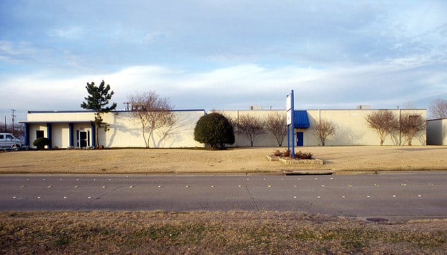
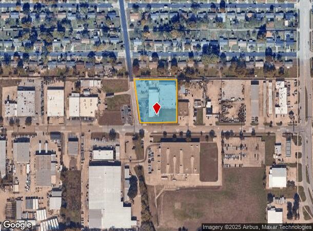
Property Record
1101 E Walnut St, Garland, TX 75040
NEARBY LISTINGS FOR SALE OR LEASE
Property Detail
1101 E Walnut St
Dallas-Fort Worth-Arlington, TX
Garvon 10
26222500070010000
GARVON 10 BLK G LT 1 & W38FT LT 2 INT200900199727 DD07022009 CO-DC 2225000700100 2CG22250007
Officebuilding
Dallas
X
Texas
48113C0240K
1,2
2024
1.63 AC
2025
NE Dallas/Garland
018105
Dallas/Ft Worth
33,000 SF
DEMOGRAPHICS near 1101 E Walnut St
1 Mile
3 Mile
5 Mile
2024 Total Population
13,341
109,771
278,988
2029 Population
13,191
108,209
276,589
Pop Growth 2024-2029
(1.12%)
(1.42%)
(0.86%)
Average Age
36
38
38
2024 Total Households
3,877
34,862
92,677
HH Growth 2024-2029
(1.37%)
(1.65%)
(1.05%)
Median Household Inc
$63,194
$68,425
$69,173
Avg Household Size
3.30
3.10
2.90
2024 Avg HH Vehicles
2.00
2.00
2.00
Median Home Value
$187,745
$221,648
$238,899
Median Year Built
1974
1977
1980
Nearby Places
Map Layers
Map Styles
 Street
 Aerial
- Restaurants
- Banks
- Shops
- Fitness
- Groceries
PUBLIC TRANSPORTATION
AIRPORT
Dallas Love Field
DRIVE
WALK
Distance
Dallas Love Field
34 min
22.2 mi
Dallas-Fort Worth International
DRIVE
WALK
Distance
Dallas-Fort Worth International
42 min
31.0 mi
Freight Ports
Port of Shreveport
DRIVE
WALK
Distance
Port of Shreveport
214 min
194.2 mi
Nearby Properties
Address
Land Use
TOTAL SIZE
Lot Size
Zoning
Address
Land Use
TOTAL SIZE
Lot Size
Zoning
650,164 SF
66.57 AC
Z02
Address
Land Use
TOTAL SIZE
Lot Size
Zoning
310,382 SF
11.78 AC
Z148
Address
Land Use
TOTAL SIZE
Lot Size
Zoning
181,854 SF
14.51 AC
Z239
Address
Land Use
TOTAL SIZE
Lot Size
Zoning
261,164 SF
32.58 AC
Address
Land Use
TOTAL SIZE
Lot Size
Zoning
342,658 SF
4.94 AC
Z239
Address
Land Use
TOTAL SIZE
Lot Size
Zoning
228,458 SF
5.56 AC
Z236
Address
Land Use
TOTAL SIZE
Lot Size
Zoning
331,684 SF
9.80 AC
Z148
Address
Land Use
TOTAL SIZE
Lot Size
Zoning
403,206 SF
4 AC
Z239
Address
Land Use
TOTAL SIZE
Lot Size
Zoning
107,686 SF
30.09 AC
Z386
Address
Land Use
TOTAL SIZE
Lot Size
Zoning
65,595 SF
19.22 AC
Z239
Address
Land Use
TOTAL SIZE
Lot Size
Zoning
187,440 SF
1.68 AC
Z25
Address
Land Use
TOTAL SIZE
Lot Size
Zoning
77,102 SF
27.47 AC
Z144
Address
Land Use
TOTAL SIZE
Lot Size
Zoning
198,488 SF
10.17 AC
Z239
Address
Land Use
TOTAL SIZE
Lot Size
Zoning
473,201 SF
13.32 AC
Address
Land Use
TOTAL SIZE
Lot Size
Zoning
163,965 SF
12.09 AC
Z239
Address
Land Use
TOTAL SIZE
Lot Size
Zoning
180,320 SF
10.66 AC
Z160
Address
Land Use
TOTAL SIZE
Lot Size
Zoning
0.12 AC
Z63
Address
Land Use
TOTAL SIZE
Lot Size
Zoning
168,537 SF
2 AC
Address
Land Use
TOTAL SIZE
Lot Size
Zoning
138,865 SF
11.38 AC
Z239
Address
Land Use
TOTAL SIZE
Lot Size
Zoning
139,133 SF
3.34 AC
Z239
Address
Land Use
TOTAL SIZE
Lot Size
Zoning
111,948 SF
9.92 AC
Z239
Address
Land Use
TOTAL SIZE
Lot Size
Zoning
133,249 SF
9.71 AC
Z239
Address
Land Use
TOTAL SIZE
Lot Size
Zoning
59,546 SF
60.69 AC
Z390
Address
Land Use
TOTAL SIZE
Lot Size
Zoning
65,917 SF
7.99 AC
Z239
Address
Land Use
TOTAL SIZE
Lot Size
Zoning
143,474 SF
5.41 AC
Z239
Address
Land Use
TOTAL SIZE
Lot Size
Zoning
177,739 SF
11.10 AC
Z390
Address
Land Use
TOTAL SIZE
Lot Size
Zoning
117,036 SF
11.89 AC
Z239
Address
Land Use
TOTAL SIZE
Lot Size
Zoning
145,203 SF
12.86 AC
Z239
Address
Land Use
TOTAL SIZE
Lot Size
Zoning
156,000 SF
2 AC
Address
Land Use
TOTAL SIZE
Lot Size
Zoning
119,397 SF
7.41 AC
Z160
The World's #1 Commercial Real Estate Marketplace
Connect with us
© 2025 CoStar Group
The information above has been obtained from sources believed reliable. While we do not doubt its accuracy we have not verified it and make no guarantee, warranty or representation about it. It is your responsibility to independently confirm its accuracy and completeness. Any projections, opinions, assumptions, or estimates used are for example only and do not represent the current or future performance of the property. The value of this transaction to you depends on tax and other factors which should be evaluated by your tax, financial, and legal advisors. You and your advisors should conduct a careful, independent investigation of the property to determine to your satisfaction the suitability of the property for your needs.