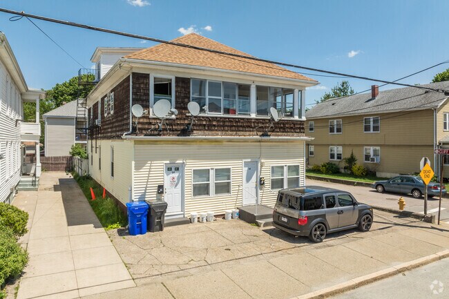
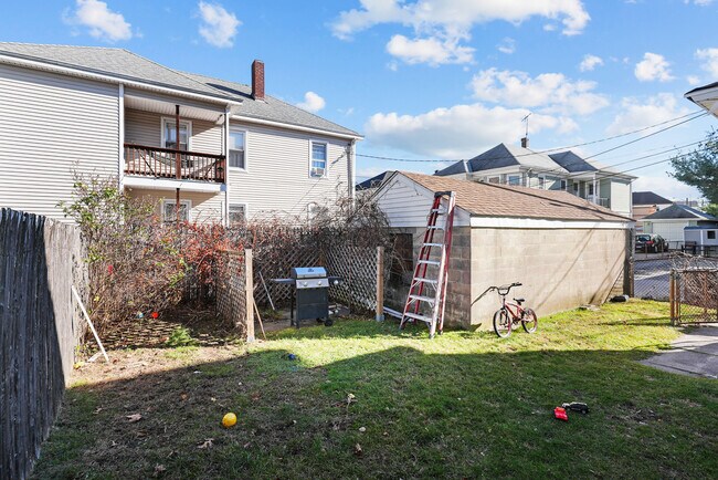
Property Record
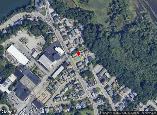
1101 Lonsdale Ave, Central Falls, RI 02863
NEARBY LISTINGS FOR SALE OR LEASE
Property Detail
1101 Lonsdale Ave
Commercialofficeresidentialmixeduse
Providence
X
Rhode Island
44007C0194J
0.09 AC
2025
Northeastern Providence County
2025
Providence
011000
Providence-Warwick, RI-MA
3,488 SF
CENT-000007-000000-000254
DEMOGRAPHICS near 1101 Lonsdale Ave
1 Mile
3 Mile
5 Mile
2024 Total Population
25,686
136,181
284,860
2029 Population
25,052
134,321
282,615
Pop Growth 2024-2029
(2.47%)
(1.37%)
(0.79%)
Average Age
36
39
39
2024 Total Households
9,173
54,383
114,575
HH Growth 2024-2029
(2.50%)
(1.46%)
(0.80%)
Median Household Inc
$47,651
$62,301
$71,061
Avg Household Size
2.70
2.40
2.30
2024 Avg HH Vehicles
1.00
2.00
2.00
Median Home Value
$283,022
$290,489
$323,287
Median Year Built
1948
1952
1955
Nearby Places
Map Layers
Map Styles
 Street
 Aerial
- Restaurants
- Banks
- Shops
- Fitness
- Groceries
PUBLIC TRANSPORTATION
COMMUTER RAIL
South Attleboro (Providence/Stoughton Line - Massachusetts Bay Transportation Authority Commuter Rail (Purple Line))
DRIVE
WALK
Distance
South Attleboro (Providence/Stoughton Line - Massachusetts Bay Transportation Authority Commuter Rail (Purple Line))
13 min
3.7 mi
Providence (Providence/Stoughton Line - Massachusetts Bay Transportation Authority Commuter Rail (Purple Line))
DRIVE
WALK
Distance
Providence (Providence/Stoughton Line - Massachusetts Bay Transportation Authority Commuter Rail (Purple Line))
14 min
5.7 mi
AIRPORT
Rhode Island Tf Green International
DRIVE
WALK
Distance
Rhode Island Tf Green International
29 min
15.4 mi
General Edward Lawrence Logan International
DRIVE
WALK
Distance
General Edward Lawrence Logan International
61 min
48.1 mi
SALE & LEASE HISTORY
LISTING DATE
SALE/LEASE

Nov 28, 2023
For Sale
Nearby Properties
Address
Land Use
TOTAL SIZE
Lot Size
Zoning
Address
Land Use
TOTAL SIZE
Lot Size
Zoning
170,531 SF
3 AC
M-2
Address
Land Use
TOTAL SIZE
Lot Size
Zoning
28,208 SF
38.19 AC
PHB
Address
Land Use
TOTAL SIZE
Lot Size
Zoning
200.05 AC
RA40
Address
Land Use
TOTAL SIZE
Lot Size
Zoning
38.50 AC
RA40
Address
Land Use
TOTAL SIZE
Lot Size
Zoning
168,150 SF
2.77 AC
PO
Address
Land Use
TOTAL SIZE
Lot Size
Zoning
3.88 AC
M-MU-7
Address
Land Use
TOTAL SIZE
Lot Size
Zoning
21 AC
RM
Address
Land Use
TOTAL SIZE
Lot Size
Zoning
134,113 SF
0.74 AC
RM
Address
Land Use
TOTAL SIZE
Lot Size
Zoning
96,300 SF
3.79 AC
RM
Address
Land Use
TOTAL SIZE
Lot Size
Zoning
4.45 AC
RM
Address
Land Use
TOTAL SIZE
Lot Size
Zoning
312,784 SF
11.53 AC
MO
Address
Land Use
TOTAL SIZE
Lot Size
Zoning
14,841 SF
15.70 AC
PHB
Address
Land Use
TOTAL SIZE
Lot Size
Zoning
88,698 SF
1.44 AC
RM
Address
Land Use
TOTAL SIZE
Lot Size
Zoning
109,700 SF
3.73 AC
RT
Address
Land Use
TOTAL SIZE
Lot Size
Zoning
14.66 AC
CG
Address
Land Use
TOTAL SIZE
Lot Size
Zoning
214,701 SF
3.14 AC
RE
Address
Land Use
TOTAL SIZE
Lot Size
Zoning
229,975 SF
32.24 AC
PC
Address
Land Use
TOTAL SIZE
Lot Size
Zoning
2.97 AC
MB
Address
Land Use
TOTAL SIZE
Lot Size
Zoning
55,103 SF
2.98 AC
RT
Address
Land Use
TOTAL SIZE
Lot Size
Zoning
147,170 SF
2.23 AC
R-3
Address
Land Use
TOTAL SIZE
Lot Size
Zoning
15,086 SF
2.61 AC
C-2
Address
Land Use
TOTAL SIZE
Lot Size
Zoning
97,858 SF
2.02 AC
R-3
Address
Land Use
TOTAL SIZE
Lot Size
Zoning
98,968 SF
1.66 AC
R-2
Address
Land Use
TOTAL SIZE
Lot Size
Zoning
189,308 SF
19.76 AC
I
Address
Land Use
TOTAL SIZE
Lot Size
Zoning
85,626 SF
2.22 AC
RT
Address
Land Use
TOTAL SIZE
Lot Size
Zoning
155,731 SF
41.03 AC
PHB
Address
Land Use
TOTAL SIZE
Lot Size
Zoning
2.23 AC
RE
Address
Land Use
TOTAL SIZE
Lot Size
Zoning
69,053 SF
0.87 AC
C-2
Address
Land Use
TOTAL SIZE
Lot Size
Zoning
80,046 SF
5.56 AC
PS
Address
Land Use
TOTAL SIZE
Lot Size
Zoning
146,404 SF
2.12 AC
MB
The World's #1 Commercial Real Estate Marketplace
Connect with us
© 2025 CoStar Group
The information above has been obtained from sources believed reliable. While we do not doubt its accuracy we have not verified it and make no guarantee, warranty or representation about it. It is your responsibility to independently confirm its accuracy and completeness. Any projections, opinions, assumptions, or estimates used are for example only and do not represent the current or future performance of the property. The value of this transaction to you depends on tax and other factors which should be evaluated by your tax, financial, and legal advisors. You and your advisors should conduct a careful, independent investigation of the property to determine to your satisfaction the suitability of the property for your needs.