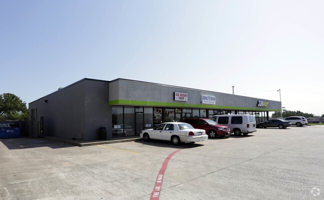
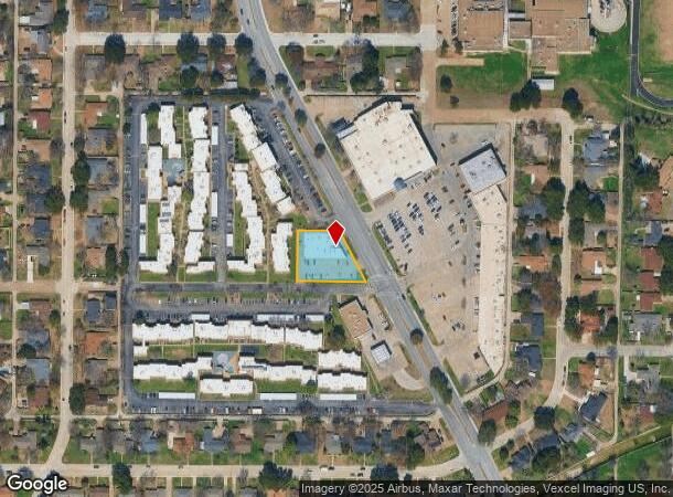
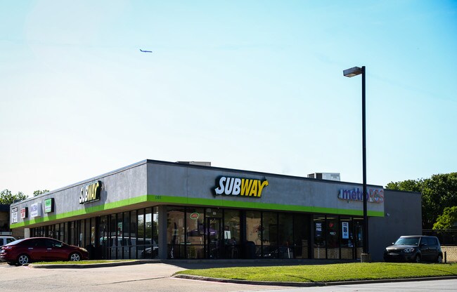
Property Record
1101 N Carrier Pky, Grand Prairie, TX 75050
NEARBY LISTINGS FOR SALE OR LEASE
Property Detail
1101 N Carrier Pky
Dallas-Fort Worth-Arlington, TX
Holiday Hill Estates
28088500200110000
HOLIDAY HILL ESTATES TR 11 ACS 0.57 INT201700182981 DD062620217 CO-DC 0885002001100 5CP08850020
Stripcommercialcenter
Dallas
X
Texas
48439C0245L
11
2024
0.57 AC
2025
North Grand Prairie
015403
Dallas/Ft Worth
7,448 SF
DEMOGRAPHICS near 1101 N Carrier Pky
1 Mile
3 Mile
5 Mile
2024 Total Population
13,414
63,547
232,658
2029 Population
13,413
63,663
236,952
Pop Growth 2024-2029
(0.01%)
+ 0.18%
+ 1.85%
Average Age
35
35
35
2024 Total Households
4,713
21,565
83,106
HH Growth 2024-2029
(0.55%)
+ 0.09%
+ 2.20%
Median Household Inc
$60,301
$51,630
$52,238
Avg Household Size
2.80
2.90
2.70
2024 Avg HH Vehicles
2.00
2.00
2.00
Median Home Value
$201,982
$183,288
$197,863
Median Year Built
1978
1975
1981
Nearby Places
Map Layers
Map Styles
 Street
 Aerial
- Restaurants
- Banks
- Shops
- Fitness
- Groceries
PUBLIC TRANSPORTATION
AIRPORT
Dallas-Fort Worth International
DRIVE
WALK
Distance
Dallas-Fort Worth International
14 min
9.9 mi
Dallas Love Field
DRIVE
WALK
Distance
Dallas Love Field
27 min
18.1 mi
SALE & LEASE HISTORY
LISTING DATE
SALE/LEASE

Sep 25, 2016
For Lease
Mar 23, 2017
For Lease
Jan 13, 2017
For Lease
Nearby Properties
Address
Land Use
TOTAL SIZE
Lot Size
Zoning
Address
Land Use
TOTAL SIZE
Lot Size
Zoning
2,395,314 SF
152.04 AC
Address
Land Use
TOTAL SIZE
Lot Size
Zoning
1,577,320 SF
122.55 AC
Z123
Address
Land Use
TOTAL SIZE
Lot Size
Zoning
703,500 SF
47.38 AC
Z236
Address
Land Use
TOTAL SIZE
Lot Size
Zoning
496,283 SF
246.29 AC
Z236
Address
Land Use
TOTAL SIZE
Lot Size
Zoning
1,261,810 SF
80.53 AC
Address
Land Use
TOTAL SIZE
Lot Size
Zoning
450,535 SF
27.23 AC
Address
Land Use
TOTAL SIZE
Lot Size
Zoning
680,900 SF
32.25 AC
Z236
Address
Land Use
TOTAL SIZE
Lot Size
Zoning
334,057 SF
20.05 AC
Z312
Address
Land Use
TOTAL SIZE
Lot Size
Zoning
358,350 SF
13.15 AC
Address
Land Use
TOTAL SIZE
Lot Size
Zoning
576,000 SF
55.36 AC
Z123
Address
Land Use
TOTAL SIZE
Lot Size
Zoning
1,054,767 SF
37.45 AC
Z123
Address
Land Use
TOTAL SIZE
Lot Size
Zoning
531,072 SF
26.50 AC
Z236
Address
Land Use
TOTAL SIZE
Lot Size
Zoning
264,010 SF
34.50 AC
Z190
Address
Land Use
TOTAL SIZE
Lot Size
Zoning
197,000 SF
25.51 AC
Z236
Address
Land Use
TOTAL SIZE
Lot Size
Zoning
283,087 SF
15.22 AC
Z236
Address
Land Use
TOTAL SIZE
Lot Size
Zoning
436,343 SF
5.36 AC
Z236
Address
Land Use
TOTAL SIZE
Lot Size
Zoning
266,448 SF
17 AC
Z97
Address
Land Use
TOTAL SIZE
Lot Size
Zoning
209,751 SF
6.65 AC
Address
Land Use
TOTAL SIZE
Lot Size
Zoning
224,486 SF
18.11 AC
Z236
Address
Land Use
TOTAL SIZE
Lot Size
Zoning
251,392 SF
14.54 AC
Z190
Address
Land Use
TOTAL SIZE
Lot Size
Zoning
492,972 SF
24.23 AC
Address
Land Use
TOTAL SIZE
Lot Size
Zoning
261,338 SF
15.55 AC
Address
Land Use
TOTAL SIZE
Lot Size
Zoning
401,600 SF
23.94 AC
Z236
Address
Land Use
TOTAL SIZE
Lot Size
Zoning
436,014 SF
47.53 AC
Z236
Address
Land Use
TOTAL SIZE
Lot Size
Zoning
226,438 SF
12.98 AC
Z190
Address
Land Use
TOTAL SIZE
Lot Size
Zoning
276,155 SF
14.70 AC
Address
Land Use
TOTAL SIZE
Lot Size
Zoning
196,056 SF
11.19 AC
Address
Land Use
TOTAL SIZE
Lot Size
Zoning
366,350 SF
18.14 AC
Z123
Address
Land Use
TOTAL SIZE
Lot Size
Zoning
746,852 SF
34.91 AC
Address
Land Use
TOTAL SIZE
Lot Size
Zoning
433,225 SF
24.02 AC
The World's #1 Commercial Real Estate Marketplace
Connect with us
© 2025 CoStar Group
The information above has been obtained from sources believed reliable. While we do not doubt its accuracy we have not verified it and make no guarantee, warranty or representation about it. It is your responsibility to independently confirm its accuracy and completeness. Any projections, opinions, assumptions, or estimates used are for example only and do not represent the current or future performance of the property. The value of this transaction to you depends on tax and other factors which should be evaluated by your tax, financial, and legal advisors. You and your advisors should conduct a careful, independent investigation of the property to determine to your satisfaction the suitability of the property for your needs.