Property Record
1101 S Capitol St Sw, Washington, DC 20003
NEARBY LISTINGS FOR SALE OR LEASE
Property Detail
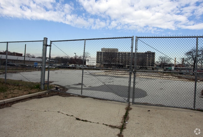
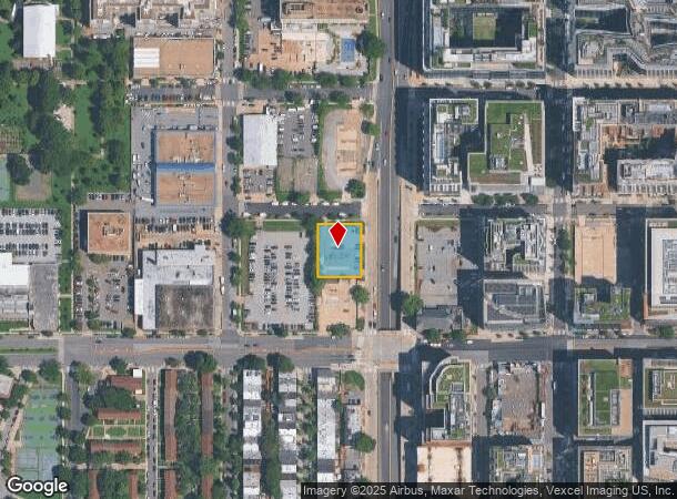
1101 S Capitol St Sw
Washington-Arlington-Alexandria, DC-VA-MD-WV
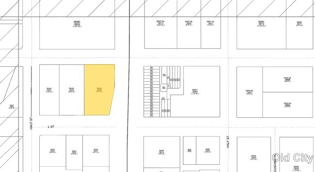
R. L. A. Sw
0649-0047
SQUARE 0649 LOT 0047 NBHD: R. L. A. SW
Parkinglot
District of Columbia
X
District of Columbia
1100010019C
47
2025
0.41 AC
2025
Capitol Riverfront
010500
Washington, DC
2,777 SF
DEMOGRAPHICS near 1101 S Capitol St Sw
1 Mile
3 Mile
5 Mile
2024 Total Population
41,324
297,317
741,930
2029 Population
39,376
276,577
694,088
Pop Growth 2024-2029
(4.71%)
(6.98%)
(6.45%)
Average Age
37
36
37
2024 Total Households
24,220
147,970
349,313
HH Growth 2024-2029
(5.47%)
(7.66%)
(7.02%)
Median Household Inc
$121,147
$96,466
$95,173
Avg Household Size
1.70
1.90
2.00
2024 Avg HH Vehicles
1.00
1.00
1.00
Median Home Value
$639,692
$669,226
$635,840
Median Year Built
2006
1971
1964
Nearby Places
Map Layers
Map Styles
 Street
 Aerial
- Restaurants
- Banks
- Shops
- Fitness
- Groceries
PUBLIC TRANSPORTATION
TRANSIT/SUBWAY
Navy Yard (Green Line - Washington Metropolitan Area Transit Authority Metrorail (Metrorail))
DRIVE
WALK
Distance
Navy Yard (Green Line - Washington Metropolitan Area Transit Authority Metrorail (Metrorail))
2 min
6 min
0.3 mi
Waterfront-SEU (Green Line - Washington Metropolitan Area Transit Authority Metrorail (Metrorail))
DRIVE
WALK
Distance
Waterfront-SEU (Green Line - Washington Metropolitan Area Transit Authority Metrorail (Metrorail))
2 min
10 min
0.5 mi
Capitol South (Blue Line - Washington Metropolitan Area Transit Authority Metrorail (Metrorail), Orange Line - Washington Metropolitan Area Transit Authority Metrorail (Metrorail), Silver Line - Washington Metropolitan Area Transit Authority Metrorail (Metrorail))
DRIVE
WALK
Distance
Capitol South (Blue Line - Washington Metropolitan Area Transit Authority Metrorail (Metrorail), Orange Line - Washington Metropolitan Area Transit Authority Metrorail (Metrorail), Silver Line - Washington Metropolitan Area Transit Authority Metrorail (Metrorail))
3 min
14 min
0.7 mi
Federal Center SW (Blue Line - Washington Metropolitan Area Transit Authority Metrorail (Metrorail), Orange Line - Washington Metropolitan Area Transit Authority Metrorail (Metrorail), Silver Line - Washington Metropolitan Area Transit Authority Metrorail (Metrorail))
DRIVE
WALK
Distance
Federal Center SW (Blue Line - Washington Metropolitan Area Transit Authority Metrorail (Metrorail), Orange Line - Washington Metropolitan Area Transit Authority Metrorail (Metrorail), Silver Line - Washington Metropolitan Area Transit Authority Metrorail (Metrorail))
3 min
18 min
0.9 mi
COMMUTER RAIL
L'Enfant (Fredericksburg Line - Virginia Railway Express, Manassas Line - Virginia Railway Express)
DRIVE
WALK
Distance
L'Enfant (Fredericksburg Line - Virginia Railway Express, Manassas Line - Virginia Railway Express)
3 min
1.3 mi
DRIVE
WALK
Distance
3 min
1.3 mi
AIRPORT
Ronald Reagan Washington Ntl
DRIVE
WALK
Distance
Ronald Reagan Washington Ntl
12 min
5.3 mi
Washington Dulles International
DRIVE
WALK
Distance
Washington Dulles International
48 min
29.5 mi
Baltimore/Washington International Thurgood Marshall
DRIVE
WALK
Distance
Baltimore/Washington International Thurgood Marshall
49 min
32.0 mi
Freight Ports
Port of Baltimore
DRIVE
WALK
Distance
Port of Baltimore
58 min
38.3 mi
Nearby Properties
Address
Land Use
TOTAL SIZE
Lot Size
Zoning
Address
Land Use
TOTAL SIZE
Lot Size
Zoning
900,000 SF
11.10 AC
S-3A
Address
Land Use
TOTAL SIZE
Lot Size
Zoning
2,300,000 SF
1.60 AC
D-5-R
Address
Land Use
TOTAL SIZE
Lot Size
Zoning
2,052,109 SF
90.60 AC
UNZONED
Address
Land Use
TOTAL SIZE
Lot Size
Zoning
128,439 SF
373.22 AC
UNZONED
Address
Land Use
TOTAL SIZE
Lot Size
Zoning
533,778 SF
18.08 AC
UNZONED
Address
Land Use
TOTAL SIZE
Lot Size
Zoning
5,483 SF
88.76 AC
GOV
Address
Land Use
TOTAL SIZE
Lot Size
Zoning
1,517,010 SF
70.25 AC
UNZONED
Address
Land Use
TOTAL SIZE
Lot Size
Zoning
142 AC
GOV
Address
Land Use
TOTAL SIZE
Lot Size
Zoning
2,493,936 SF
8.99 AC
UNZONED
Address
Land Use
TOTAL SIZE
Lot Size
Zoning
3.71 AC
UNZONED
Address
Land Use
TOTAL SIZE
Lot Size
Zoning
63.89 AC
GOV
Address
Land Use
TOTAL SIZE
Lot Size
Zoning
19.46 AC
CG-4
Address
Land Use
TOTAL SIZE
Lot Size
Zoning
3,750,395 SF
10.82 AC
UNZONED
Address
Land Use
TOTAL SIZE
Lot Size
Zoning
262,673 SF
5.35 AC
D-7
Address
Land Use
TOTAL SIZE
Lot Size
Zoning
1,530,865 SF
6.05 AC
D-6;UNZONE
Address
Land Use
TOTAL SIZE
Lot Size
Zoning
6,500,000 SF
92.03 AC
S-3A
Address
Land Use
TOTAL SIZE
Lot Size
Zoning
2,369,428 SF
7.93 AC
MU-10;SEFC
Address
Land Use
TOTAL SIZE
Lot Size
Zoning
42.57 AC
GOV
Address
Land Use
TOTAL SIZE
Lot Size
Zoning
2,455,000 SF
11.08 AC
MU-2
Address
Land Use
TOTAL SIZE
Lot Size
Zoning
52.44 AC
UNZONED
Address
Land Use
TOTAL SIZE
Lot Size
Zoning
1,100,000 SF
2.13 AC
D-6
Address
Land Use
TOTAL SIZE
Lot Size
Zoning
1,310,661 SF
3.38 AC
D-6
Address
Land Use
TOTAL SIZE
Lot Size
Zoning
1,043,058 SF
4.03 AC
UNZONED
Address
Land Use
TOTAL SIZE
Lot Size
Zoning
1,336,013 SF
5.41 AC
D-5
Address
Land Use
TOTAL SIZE
Lot Size
Zoning
1,738,573 SF
2.11 AC
D-7
Address
Land Use
TOTAL SIZE
Lot Size
Zoning
1,081,367 SF
6.46 AC
UNZONED
Address
Land Use
TOTAL SIZE
Lot Size
Zoning
185,826 SF
9.40 AC
UNZONED
Address
Land Use
TOTAL SIZE
Lot Size
Zoning
1.57 AC
D-5
Address
Land Use
TOTAL SIZE
Lot Size
Zoning
2,058,692 SF
4.77 AC
UNZONED
Address
Land Use
TOTAL SIZE
Lot Size
Zoning
1,015,833 SF
1.60 AC
D-7
The World's #1 Commercial Real Estate Marketplace
Connect with us
© 2025 CoStar Group
The information above has been obtained from sources believed reliable. While we do not doubt its accuracy we have not verified it and make no guarantee, warranty or representation about it. It is your responsibility to independently confirm its accuracy and completeness. Any projections, opinions, assumptions, or estimates used are for example only and do not represent the current or future performance of the property. The value of this transaction to you depends on tax and other factors which should be evaluated by your tax, financial, and legal advisors. You and your advisors should conduct a careful, independent investigation of the property to determine to your satisfaction the suitability of the property for your needs.