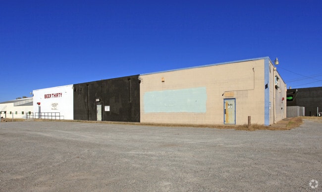
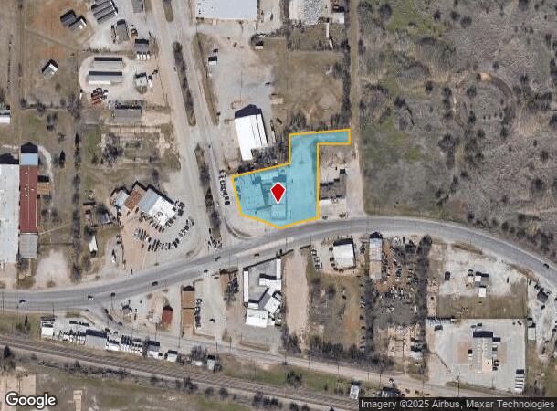
Property Record
1101 Sheppard Access Rd, Wichita Falls, TX 76306

NEARBY LISTINGS FOR SALE OR LEASE
Property Detail
1101 Sheppard Access Rd
Wichita Falls, TX
Abst. 298 - J
124406
LOT 1 R B WILLIAMS ADD A-298
Bartavern
Wichita
AE
Texas
48485C0320G
1
2024
1.63 AC
2025
North Wichita Falls
013201
Other Market Areas
16,184 SF
DEMOGRAPHICS near 1101 Sheppard Access Rd
1 Mile
3 Mile
5 Mile
2024 Total Population
3,020
37,226
76,320
2029 Population
3,153
38,583
78,353
Pop Growth 2024-2029
+ 4.40%
+ 3.65%
+ 2.66%
Average Age
37
37
37
2024 Total Households
1,201
14,721
29,187
HH Growth 2024-2029
+ 4.41%
+ 3.86%
+ 2.84%
Median Household Inc
$26,550
$40,157
$47,589
Avg Household Size
2.40
2.30
2.30
2024 Avg HH Vehicles
1.00
2.00
2.00
Median Home Value
$67,105
$79,323
$114,969
Median Year Built
1957
1959
1966
Nearby Places
Map Layers
Map Styles
 Street
 Aerial
- Restaurants
- Banks
- Shops
- Fitness
- Groceries
Nearby Properties
Address
Land Use
TOTAL SIZE
Lot Size
Zoning
Address
Land Use
TOTAL SIZE
Lot Size
Zoning
4,501.47 AC
Address
Land Use
TOTAL SIZE
Lot Size
Zoning
164,255 SF
5.23 AC
Address
Land Use
TOTAL SIZE
Lot Size
Zoning
398,646 SF
7.51 AC
GC
Address
Land Use
TOTAL SIZE
Lot Size
Zoning
203,569 SF
27.74 AC
Address
Land Use
TOTAL SIZE
Lot Size
Zoning
245,152 SF
5.12 AC
GC
Address
Land Use
TOTAL SIZE
Lot Size
Zoning
233,084 SF
44.31 AC
SF2
Address
Land Use
TOTAL SIZE
Lot Size
Zoning
24,741 SF
37.75 AC
Address
Land Use
TOTAL SIZE
Lot Size
Zoning
266,509 SF
14.25 AC
SF2
Address
Land Use
TOTAL SIZE
Lot Size
Zoning
200,421 SF
18.57 AC
MFR
Address
Land Use
TOTAL SIZE
Lot Size
Zoning
158,784 SF
69.19 AC
Address
Land Use
TOTAL SIZE
Lot Size
Zoning
167,247 SF
2.61 AC
CBD
Address
Land Use
TOTAL SIZE
Lot Size
Zoning
51,240 SF
3.46 AC
GC
Address
Land Use
TOTAL SIZE
Lot Size
Zoning
125,992 SF
4.22 AC
Address
Land Use
TOTAL SIZE
Lot Size
Zoning
80,294 SF
9.17 AC
Address
Land Use
TOTAL SIZE
Lot Size
Zoning
120,073 SF
17.43 AC
Address
Land Use
TOTAL SIZE
Lot Size
Zoning
136,522 SF
4.11 AC
Address
Land Use
TOTAL SIZE
Lot Size
Zoning
95,926 SF
1.21 AC
CBD
Address
Land Use
TOTAL SIZE
Lot Size
Zoning
101,451 SF
11.91 AC
RMU
Address
Land Use
TOTAL SIZE
Lot Size
Zoning
125,809 SF
2.01 AC
GC
Address
Land Use
TOTAL SIZE
Lot Size
Zoning
109,536 SF
27.02 AC
Address
Land Use
TOTAL SIZE
Lot Size
Zoning
131,525 SF
4,501.50 AC
Address
Land Use
TOTAL SIZE
Lot Size
Zoning
108,972 SF
1.41 AC
CBD
Address
Land Use
TOTAL SIZE
Lot Size
Zoning
183,184 SF
21.89 AC
GC
Address
Land Use
TOTAL SIZE
Lot Size
Zoning
115,350 SF
4.86 AC
SF2
Address
Land Use
TOTAL SIZE
Lot Size
Zoning
34,268 SF
1.27 AC
Address
Land Use
TOTAL SIZE
Lot Size
Zoning
143,878 SF
20.85 AC
MFR
Address
Land Use
TOTAL SIZE
Lot Size
Zoning
64,637 SF
25.40 AC
Address
Land Use
TOTAL SIZE
Lot Size
Zoning
81,007 SF
23.24 AC
GC
Address
Land Use
TOTAL SIZE
Lot Size
Zoning
115,934 SF
2.63 AC
RDD
Address
Land Use
TOTAL SIZE
Lot Size
Zoning
138,450 SF
2.61 AC
CBD
The World's #1 Commercial Real Estate Marketplace
Connect with us
© 2025 CoStar Group
The information above has been obtained from sources believed reliable. While we do not doubt its accuracy we have not verified it and make no guarantee, warranty or representation about it. It is your responsibility to independently confirm its accuracy and completeness. Any projections, opinions, assumptions, or estimates used are for example only and do not represent the current or future performance of the property. The value of this transaction to you depends on tax and other factors which should be evaluated by your tax, financial, and legal advisors. You and your advisors should conduct a careful, independent investigation of the property to determine to your satisfaction the suitability of the property for your needs.