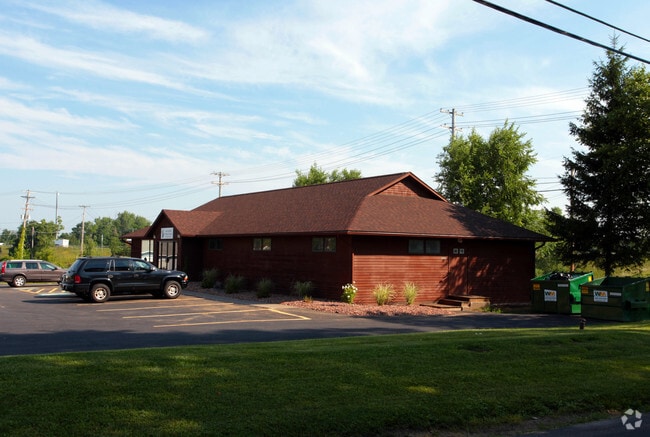
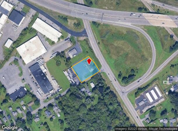
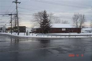
Property Record
1101 State Fair Blvd, Syracuse, NY 13209

NEARBY LISTINGS FOR SALE OR LEASE
Property Detail
1101 State Fair Blvd
313289-019-000-0001-019-001-0000
LAKESIDE RD SCHOOL SITE 0190119 4450000302008
Storesoffices
Onondaga
X
New York
36067C0182F
19.001
2025
0.92 AC
2024
W Outer Onondaga County
012800
Syracuse
2,961 SF
Syracuse, NY
DEMOGRAPHICS near 1101 State Fair Blvd
1 Mile
3 Mile
5 Mile
2024 Total Population
1,887
24,519
100,781
2029 Population
1,837
23,898
98,083
Pop Growth 2024-2029
(2.65%)
(2.53%)
(2.68%)
Average Age
46
42
42
2024 Total Households
798
10,620
43,403
HH Growth 2024-2029
(2.76%)
(2.74%)
(2.90%)
Median Household Inc
$79,924
$65,850
$69,708
Avg Household Size
2.30
2.20
2.30
2024 Avg HH Vehicles
2.00
2.00
2.00
Median Home Value
$139,565
$156,348
$163,122
Median Year Built
1967
1967
1968
Nearby Places
- Restaurants
- Banks
- Shops
- Fitness
- Groceries
PUBLIC TRANSPORTATION
COMMUTER RAIL
DRIVE
WALK
Distance
9 min
4.7 mi
DRIVE
WALK
Distance
11 min
6.9 mi
AIRPORT
Syracuse Hancock International
DRIVE
WALK
Distance
Syracuse Hancock International
19 min
11.6 mi
Nearby Properties
Address
Land Use
TOTAL SIZE
Lot Size
Zoning
Address
Land Use
TOTAL SIZE
Lot Size
Zoning
52,800 SF
691.95 AC
06 - INDUS
Address
Land Use
TOTAL SIZE
Lot Size
Zoning
7,392 SF
14.86 AC
03 - MULTI
Address
Land Use
TOTAL SIZE
Lot Size
Zoning
257,617 SF
50.74 AC
INA
Address
Land Use
TOTAL SIZE
Lot Size
Zoning
3,968 SF
14.31 AC
03 - MULTI
Address
Land Use
TOTAL SIZE
Lot Size
Zoning
163,725 SF
21.46 AC
02 - SINGL
Address
Land Use
TOTAL SIZE
Lot Size
Zoning
7,229 SF
111.29 AC
05 - COMME
Address
Land Use
TOTAL SIZE
Lot Size
Zoning
11,952 SF
9.14 AC
03 - MULTI
Address
Land Use
TOTAL SIZE
Lot Size
Zoning
65,027 SF
262.57 AC
06 - INDUS
Address
Land Use
TOTAL SIZE
Lot Size
Zoning
32,586 SF
6.87 AC
06 - INDUS
Address
Land Use
TOTAL SIZE
Lot Size
Zoning
57,993 SF
18.43 AC
02 - SINGL
Address
Land Use
TOTAL SIZE
Lot Size
Zoning
3,640 SF
27.54 AC
INC
Address
Land Use
TOTAL SIZE
Lot Size
Zoning
3,744 SF
10.60 AC
03 - MULTI
Address
Land Use
TOTAL SIZE
Lot Size
Zoning
3,696 SF
10.12 AC
03 - MULTI
Address
Land Use
TOTAL SIZE
Lot Size
Zoning
2,624 SF
252.09 AC
06 - INDUS
Address
Land Use
TOTAL SIZE
Lot Size
Zoning
71,194 SF
10.76 AC
02 - SINGL
Address
Land Use
TOTAL SIZE
Lot Size
Zoning
210,170 SF
17.87 AC
06 - INDUS
Address
Land Use
TOTAL SIZE
Lot Size
Zoning
182.16 AC
02 - SINGL
Address
Land Use
TOTAL SIZE
Lot Size
Zoning
77,978 SF
21.91 AC
INA
Address
Land Use
TOTAL SIZE
Lot Size
Zoning
38,620 SF
29.42 AC
02 - SINGL
Address
Land Use
TOTAL SIZE
Lot Size
Zoning
125,780 SF
10.13 AC
02 - SINGL
Address
Land Use
TOTAL SIZE
Lot Size
Zoning
515,918 SF
14.76 AC
05 - COMME
Address
Land Use
TOTAL SIZE
Lot Size
Zoning
56,548 SF
17 AC
R10
Address
Land Use
TOTAL SIZE
Lot Size
Zoning
13,911 SF
2.48 AC
03 - MULTI
Address
Land Use
TOTAL SIZE
Lot Size
Zoning
291.81 AC
04 - FARM
Address
Land Use
TOTAL SIZE
Lot Size
Zoning
68,076 SF
8.33 AC
03 - MULTI
Address
Land Use
TOTAL SIZE
Lot Size
Zoning
40,568 SF
24.23 AC
02 - SINGL
Address
Land Use
TOTAL SIZE
Lot Size
Zoning
17,251 SF
32.17 AC
08 - GOVER
Address
Land Use
TOTAL SIZE
Lot Size
Zoning
23,820 SF
0.49 AC
05 - COMME
Address
Land Use
TOTAL SIZE
Lot Size
Zoning
35,042 SF
4.39 AC
03 - MULTI
Address
Land Use
TOTAL SIZE
Lot Size
Zoning
16,589 SF
0.50 AC
05 - COMME
The World's #1 Commercial Real Estate Marketplace
Connect with us
© 2025 CoStar Group
The information above has been obtained from sources believed reliable. While we do not doubt its accuracy we have not verified it and make no guarantee, warranty or representation about it. It is your responsibility to independently confirm its accuracy and completeness. Any projections, opinions, assumptions, or estimates used are for example only and do not represent the current or future performance of the property. The value of this transaction to you depends on tax and other factors which should be evaluated by your tax, financial, and legal advisors. You and your advisors should conduct a careful, independent investigation of the property to determine to your satisfaction the suitability of the property for your needs.