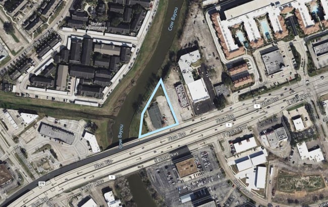
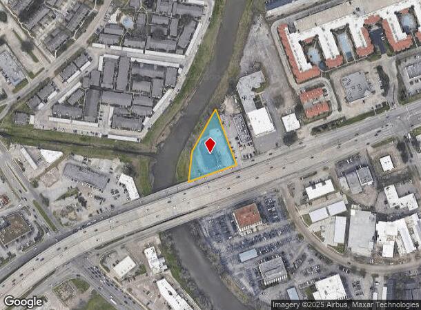
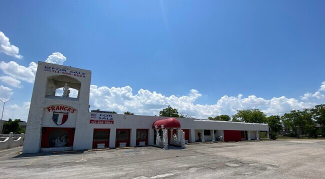
Property Record
1101 W Nasa Pkwy, Webster, TX 77598
NEARBY LISTINGS FOR SALE OR LEASE
Property Detail
1101 W Nasa Pkwy
0402110000022
Abst 13 S Deel
Easement
TR 15 ABST 13 S DEEL
AE
Harris
48167C0036G
Texas
2024
0.91 AC
2025
NASA/Clear Lake
341201
Houston
8,280 SF
Houston-The Woodlands-Sugar Land, TX
DEMOGRAPHICS near 1101 W Nasa Pkwy
1 Mile
3 Mile
5 Mile
2024 Total Population
12,998
73,557
193,896
2029 Population
13,316
75,380
198,725
Pop Growth 2024-2029
+ 2.45%
+ 2.48%
+ 2.49%
Average Age
37
39
39
2024 Total Households
6,167
32,362
77,195
HH Growth 2024-2029
+ 2.34%
+ 2.47%
+ 2.58%
Median Household Inc
$59,804
$67,794
$89,016
Avg Household Size
2.10
2.20
2.50
2024 Avg HH Vehicles
1.00
2.00
2.00
Median Home Value
$320,100
$256,631
$277,142
Median Year Built
1986
1983
1988
Nearby Places
- Restaurants
- Banks
- Shops
- Fitness
- Groceries
PUBLIC TRANSPORTATION
AIRPORT
William P Hobby
DRIVE
WALK
Distance
William P Hobby
27 min
15.1 mi
George Bush Intcntl/Houston
DRIVE
WALK
Distance
George Bush Intcntl/Houston
55 min
44.6 mi
Freight Ports
Port of Houston
DRIVE
WALK
Distance
Port of Houston
31 min
21.6 mi
SALE & LEASE HISTORY
LISTING DATE
SALE/LEASE

Oct 14, 2024
For Sale
Jan 11, 2023
For Sale
Feb 10, 2023
For Lease
Dec 02, 2020
For Sale
Nearby Properties
Address
Land Use
TOTAL SIZE
Lot Size
Zoning
Address
Land Use
TOTAL SIZE
Lot Size
Zoning
481,152 SF
22.69 AC
Address
Land Use
TOTAL SIZE
Lot Size
Zoning
544,605 SF
27.49 AC
Address
Land Use
TOTAL SIZE
Lot Size
Zoning
538,570 SF
16.15 AC
Address
Land Use
TOTAL SIZE
Lot Size
Zoning
645,535 SF
4.40 AC
Address
Land Use
TOTAL SIZE
Lot Size
Zoning
417,465 SF
61.39 AC
Address
Land Use
TOTAL SIZE
Lot Size
Zoning
585,632 SF
7.24 AC
Address
Land Use
TOTAL SIZE
Lot Size
Zoning
614,377 SF
26.06 AC
Address
Land Use
TOTAL SIZE
Lot Size
Zoning
780,870 SF
22.72 AC
Address
Land Use
TOTAL SIZE
Lot Size
Zoning
363,876 SF
11.74 AC
Address
Land Use
TOTAL SIZE
Lot Size
Zoning
335,717 SF
21.15 AC
Address
Land Use
TOTAL SIZE
Lot Size
Zoning
502,791 SF
123.05 AC
Address
Land Use
TOTAL SIZE
Lot Size
Zoning
218,198 SF
7.27 AC
Address
Land Use
TOTAL SIZE
Lot Size
Zoning
452,269 SF
29.63 AC
Address
Land Use
TOTAL SIZE
Lot Size
Zoning
323,638 SF
25.17 AC
Address
Land Use
TOTAL SIZE
Lot Size
Zoning
530,696 SF
8.57 AC
Address
Land Use
TOTAL SIZE
Lot Size
Zoning
345,470 SF
9.06 AC
Address
Land Use
TOTAL SIZE
Lot Size
Zoning
282,860 SF
8.67 AC
Address
Land Use
TOTAL SIZE
Lot Size
Zoning
366,202 SF
32.55 AC
Address
Land Use
TOTAL SIZE
Lot Size
Zoning
485,863 SF
4.81 AC
Address
Land Use
TOTAL SIZE
Lot Size
Zoning
312,331 SF
16.10 AC
Address
Land Use
TOTAL SIZE
Lot Size
Zoning
372,183 SF
11.16 AC
Address
Land Use
TOTAL SIZE
Lot Size
Zoning
185,172 SF
4.15 AC
Address
Land Use
TOTAL SIZE
Lot Size
Zoning
437,909 SF
27.06 AC
Address
Land Use
TOTAL SIZE
Lot Size
Zoning
166,816 SF
18.55 AC
Address
Land Use
TOTAL SIZE
Lot Size
Zoning
372,831 SF
20 AC
Address
Land Use
TOTAL SIZE
Lot Size
Zoning
441,889 SF
17.88 AC
Address
Land Use
TOTAL SIZE
Lot Size
Zoning
282,246 SF
19.56 AC
Address
Land Use
TOTAL SIZE
Lot Size
Zoning
335,315 SF
20 AC
Address
Land Use
TOTAL SIZE
Lot Size
Zoning
334,876 SF
0.86 AC
Address
Land Use
TOTAL SIZE
Lot Size
Zoning
879,410 SF
93.36 AC
The World's #1 Commercial Real Estate Marketplace
Connect with us
© 2025 CoStar Group
The information above has been obtained from sources believed reliable. While we do not doubt its accuracy we have not verified it and make no guarantee, warranty or representation about it. It is your responsibility to independently confirm its accuracy and completeness. Any projections, opinions, assumptions, or estimates used are for example only and do not represent the current or future performance of the property. The value of this transaction to you depends on tax and other factors which should be evaluated by your tax, financial, and legal advisors. You and your advisors should conduct a careful, independent investigation of the property to determine to your satisfaction the suitability of the property for your needs.