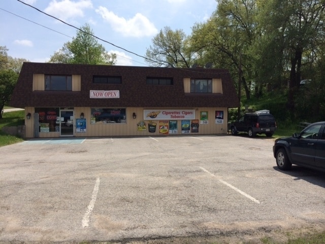
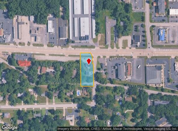
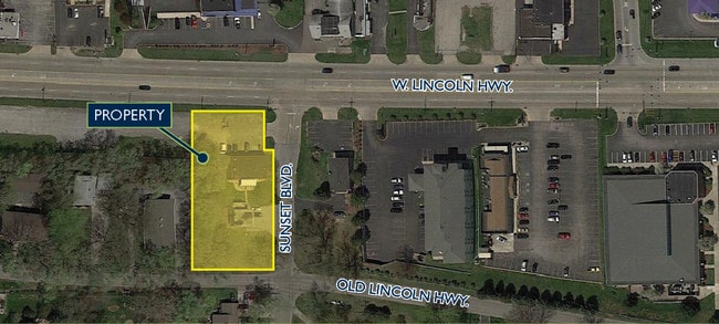
Property Record
1101 W Us Highway 30, Schererville, IN 46375
Current Lease Availabilities
NEARBY LISTINGS FOR SALE OR LEASE
Property Detail
1101 W Us Highway 30
45-11-17-203-007.000-036
PT W.131.48FT OF E.651.98FT OF S.337FT OF NW1/4 NE1/4 S.17 T.35 R.9 0.722AC TAXA BLE (0.223AC IN ROAD)
Storebuilding
Lake
X
Indiana
18089C0226E
1
2023
0.72 AC
2024
Indiana
042702
Chicago
4,032 SF
Chicago-Naperville-Elgin, IL-IN-WI
DEMOGRAPHICS near 1101 W Us Highway 30
1 Mile
3 Mile
5 Mile
2024 Total Population
5,951
47,630
140,248
2029 Population
5,888
47,226
139,426
Pop Growth 2024-2029
(1.06%)
(0.85%)
(0.59%)
Average Age
44
44
42
2024 Total Households
2,791
19,151
54,599
HH Growth 2024-2029
(1.04%)
(0.89%)
(0.66%)
Median Household Inc
$68,307
$92,342
$86,562
Avg Household Size
2.10
2.40
2.50
2024 Avg HH Vehicles
2.00
2.00
2.00
Median Home Value
$275,058
$276,354
$254,805
Median Year Built
1991
1988
1980
Nearby Places
- Restaurants
- Banks
- Shops
- Fitness
- Groceries
PUBLIC TRANSPORTATION
COMMUTER RAIL
Dyer Amtrak (Cardinal - Amtrak)
DRIVE
WALK
Distance
Dyer Amtrak (Cardinal - Amtrak)
7 min
3.7 mi
AIRPORT
Chicago Midway International
DRIVE
WALK
Distance
Chicago Midway International
50 min
32.0 mi
Freight Ports
Port Milwaukee
DRIVE
WALK
Distance
Port Milwaukee
153 min
118.3 mi
Nearby Properties
Address
Land Use
TOTAL SIZE
Lot Size
Zoning
Address
Land Use
TOTAL SIZE
Lot Size
Zoning
552,813 SF
26.48 AC
Address
Land Use
TOTAL SIZE
Lot Size
Zoning
168,766 SF
19.16 AC
Address
Land Use
TOTAL SIZE
Lot Size
Zoning
143,274 SF
17.90 AC
1116
Address
Land Use
TOTAL SIZE
Lot Size
Zoning
130,558 SF
9.89 AC
R33
Address
Land Use
TOTAL SIZE
Lot Size
Zoning
81,622 SF
9.20 AC
Address
Land Use
TOTAL SIZE
Lot Size
Zoning
100,659 SF
3.89 AC
Address
Land Use
TOTAL SIZE
Lot Size
Zoning
190,457 SF
10.63 AC
Address
Land Use
TOTAL SIZE
Lot Size
Zoning
214,752 SF
10.41 AC
R3
Address
Land Use
TOTAL SIZE
Lot Size
Zoning
246,302 SF
13.08 AC
Address
Land Use
TOTAL SIZE
Lot Size
Zoning
90,526 SF
22.99 AC
R33
Address
Land Use
TOTAL SIZE
Lot Size
Zoning
138,332 SF
7.08 AC
Address
Land Use
TOTAL SIZE
Lot Size
Zoning
80,444 SF
13.41 AC
R3
Address
Land Use
TOTAL SIZE
Lot Size
Zoning
132,147 SF
44.38 AC
R33
Address
Land Use
TOTAL SIZE
Lot Size
Zoning
64,855 SF
5 AC
Address
Land Use
TOTAL SIZE
Lot Size
Zoning
233,769 SF
29.04 AC
R3
Address
Land Use
TOTAL SIZE
Lot Size
Zoning
87,836 SF
14.12 AC
R33
Address
Land Use
TOTAL SIZE
Lot Size
Zoning
62,026 SF
9.70 AC
Address
Land Use
TOTAL SIZE
Lot Size
Zoning
64,971 SF
6.98 AC
Address
Land Use
TOTAL SIZE
Lot Size
Zoning
119,059 SF
10.12 AC
R33
Address
Land Use
TOTAL SIZE
Lot Size
Zoning
176,859 SF
12.01 AC
R33
Address
Land Use
TOTAL SIZE
Lot Size
Zoning
66,240 SF
0.45 AC
Address
Land Use
TOTAL SIZE
Lot Size
Zoning
60,992 SF
11.38 AC
R33
Address
Land Use
TOTAL SIZE
Lot Size
Zoning
34,116 SF
73.40 AC
Address
Land Use
TOTAL SIZE
Lot Size
Zoning
129,320 SF
3.96 AC
Address
Land Use
TOTAL SIZE
Lot Size
Zoning
158,292 SF
8.20 AC
Address
Land Use
TOTAL SIZE
Lot Size
Zoning
47,881 SF
23.63 AC
R33
Address
Land Use
TOTAL SIZE
Lot Size
Zoning
134,080 SF
10 AC
Address
Land Use
TOTAL SIZE
Lot Size
Zoning
53,096 SF
8.64 AC
R3
Address
Land Use
TOTAL SIZE
Lot Size
Zoning
78,221 SF
6.37 AC
Address
Land Use
TOTAL SIZE
Lot Size
Zoning
156,258 SF
4.80 AC
The World's #1 Commercial Real Estate Marketplace
Connect with us
© 2025 CoStar Group
The information above has been obtained from sources believed reliable. While we do not doubt its accuracy we have not verified it and make no guarantee, warranty or representation about it. It is your responsibility to independently confirm its accuracy and completeness. Any projections, opinions, assumptions, or estimates used are for example only and do not represent the current or future performance of the property. The value of this transaction to you depends on tax and other factors which should be evaluated by your tax, financial, and legal advisors. You and your advisors should conduct a careful, independent investigation of the property to determine to your satisfaction the suitability of the property for your needs.