Property Record
11011 State Route 128, Harrison, OH 45030

NEARBY LISTINGS FOR SALE OR LEASE
-
-
View all Harrison listings for sale on LoopNet.com
Property Detail
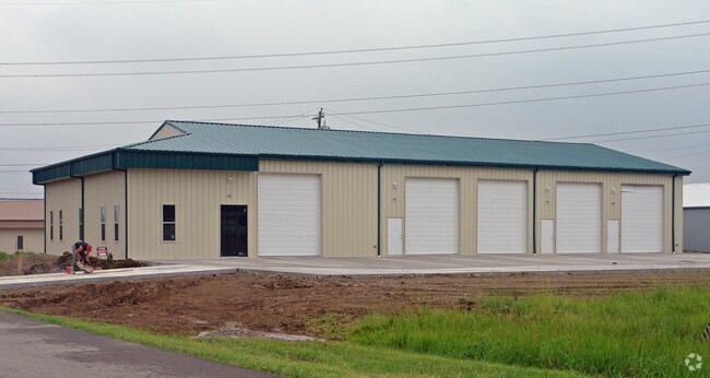
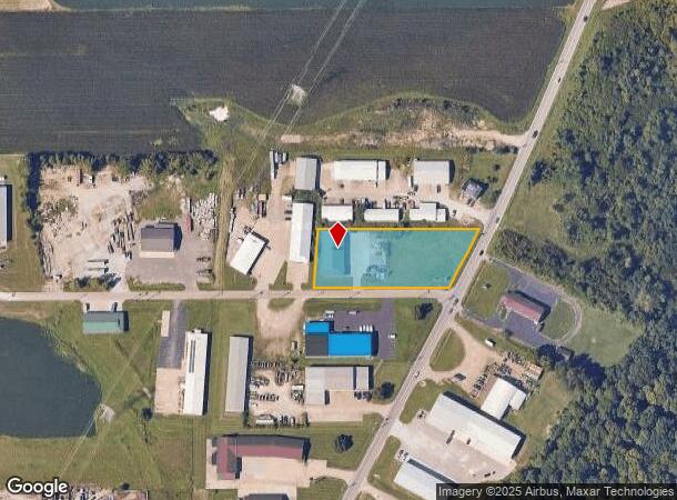
11011 State Route 128
Cincinnati, OH-KY-IN
Oakridge Industrialpark Sub
530-0060-0052
STATE ROUTE #128 1.483 ACLOT 2 OAKRIDGE INDUSTRIALPARK SUB
Warehouse
Hamilton
X
Ohio
39017C0291F
2
2024
1.48 AC
2024
West
026002
Cincinnati/Dayton
DEMOGRAPHICS near 11011 State Route 128
1 Mile
3 Mile
5 Mile
2024 Total Population
1,306
6,637
26,705
2029 Population
1,329
6,658
26,417
Pop Growth 2024-2029
+ 1.76%
+ 0.32%
(1.08%)
Average Age
35
41
41
2024 Total Households
445
2,469
10,316
HH Growth 2024-2029
+ 1.57%
0.00%
(1.39%)
Median Household Inc
$101,042
$87,385
$97,468
Avg Household Size
2.80
2.60
2.60
2024 Avg HH Vehicles
2.00
2.00
2.00
Median Home Value
$300,289
$278,888
$267,016
Median Year Built
2010
1978
1985
Nearby Places
Map Layers
Map Styles
 Street
 Aerial
- Restaurants
- Banks
- Shops
- Fitness
- Groceries
PUBLIC TRANSPORTATION
AIRPORT
Cincinnati/Northern Kentucky International
DRIVE
WALK
Distance
Cincinnati/Northern Kentucky International
51 min
33.7 mi
Freight Ports
Port of Toledo
DRIVE
WALK
Distance
Port of Toledo
246 min
202.3 mi
Nearby Properties
Address
Land Use
TOTAL SIZE
Lot Size
Zoning
Address
Land Use
TOTAL SIZE
Lot Size
Zoning
9.37 AC
Address
Land Use
TOTAL SIZE
Lot Size
Zoning
6.03 AC
Address
Land Use
TOTAL SIZE
Lot Size
Zoning
4,389 SF
314.28 AC
Address
Land Use
TOTAL SIZE
Lot Size
Zoning
222.95 AC
Address
Land Use
TOTAL SIZE
Lot Size
Zoning
234.07 AC
Address
Land Use
TOTAL SIZE
Lot Size
Zoning
14,256 SF
4.30 AC
Address
Land Use
TOTAL SIZE
Lot Size
Zoning
3,624 SF
173.58 AC
Address
Land Use
TOTAL SIZE
Lot Size
Zoning
7,987 SF
167.64 AC
Address
Land Use
TOTAL SIZE
Lot Size
Zoning
183.50 AC
Address
Land Use
TOTAL SIZE
Lot Size
Zoning
3,760 SF
161.72 AC
Address
Land Use
TOTAL SIZE
Lot Size
Zoning
6,618 SF
104.12 AC
Address
Land Use
TOTAL SIZE
Lot Size
Zoning
5,856 SF
118.92 AC
Address
Land Use
TOTAL SIZE
Lot Size
Zoning
5,382 SF
96.12 AC
Address
Land Use
TOTAL SIZE
Lot Size
Zoning
19,303 SF
8.79 AC
Address
Land Use
TOTAL SIZE
Lot Size
Zoning
Address
Land Use
TOTAL SIZE
Lot Size
Zoning
15.89 AC
Address
Land Use
TOTAL SIZE
Lot Size
Zoning
6.57 AC
Address
Land Use
TOTAL SIZE
Lot Size
Zoning
3,200 SF
122.43 AC
Address
Land Use
TOTAL SIZE
Lot Size
Zoning
43,000 SF
5.01 AC
Address
Land Use
TOTAL SIZE
Lot Size
Zoning
1,560 SF
29.25 AC
Address
Land Use
TOTAL SIZE
Lot Size
Zoning
87.52 AC
Address
Land Use
TOTAL SIZE
Lot Size
Zoning
4,444 SF
97.52 AC
Address
Land Use
TOTAL SIZE
Lot Size
Zoning
Address
Land Use
TOTAL SIZE
Lot Size
Zoning
2.89 AC
Address
Land Use
TOTAL SIZE
Lot Size
Zoning
8,089 SF
18.23 AC
Address
Land Use
TOTAL SIZE
Lot Size
Zoning
118.44 AC
Address
Land Use
TOTAL SIZE
Lot Size
Zoning
95.50 AC
Address
Land Use
TOTAL SIZE
Lot Size
Zoning
108.75 AC
Address
Land Use
TOTAL SIZE
Lot Size
Zoning
Address
Land Use
TOTAL SIZE
Lot Size
Zoning
31,096 SF
14.71 AC
The World's #1 Commercial Real Estate Marketplace
Connect with us
© 2025 CoStar Group
The information above has been obtained from sources believed reliable. While we do not doubt its accuracy we have not verified it and make no guarantee, warranty or representation about it. It is your responsibility to independently confirm its accuracy and completeness. Any projections, opinions, assumptions, or estimates used are for example only and do not represent the current or future performance of the property. The value of this transaction to you depends on tax and other factors which should be evaluated by your tax, financial, and legal advisors. You and your advisors should conduct a careful, independent investigation of the property to determine to your satisfaction the suitability of the property for your needs.