Property Record
220 Gym St, Taylor, TX 76574
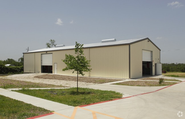

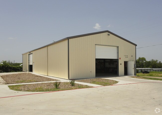
Property Detail
220 Gym St
R102509
AW0131 COURSEY, P. SUR., TRACT 317, ACRES 20.758
Industrialgeneral
WILLIAMSON
2-M1
Texas
AE The base floodplain where base flood elevations are provided. AE Zones are now used on new format FIRMs instead of A1-A30 Zones.
317
2024
20.76 AC
2025
Georgetown
021000
Austin
17,784 SF
Austin-Round Rock-San Marcos, TX
NEARBY LISTINGS FOR SALE OR LEASE
DEMOGRAPHICS near 220 Gym St
1 mile
3 mile
5 mile
2025 Total Population
4,258
19,482
21,194
2030 Population
4,892
22,288
24,257
Pop Growth 2025-2030
+ 14.89%
+ 14.40%
+ 14.45%
Average Age
39
40
40
2025 Total Households
1,587
7,280
7,938
HH Growth 2025-2030
+ 15.37%
+ 14.88%
+ 14.93%
Median Household Inc
$56,578
$71,910
$72,572
Avg Household Size
2.60
2.60
2.60
2025 Avg HH Vehicles
2.00
2.00
2.00
Median Home Value
$422,628
$326,856
$332,054
Median Year Built
1980
1983
1984
Nearby Places
Map Layers
Map Styles
 Street
 Aerial
Layers
 Traffic
 Biking
Places
Listings with unknown addresses are not visible on the map
- Restaurants
- Banks
- Shops
- Fitness
- Groceries
PUBLIC TRANSPORTATION
COMMUTER RAIL
Taylor Amtrak (Texas Eagle - Amtrak)
Drive
Walk
Distance
Taylor Amtrak (Texas Eagle - Amtrak)
2 min
16 min
0.9 mi
Freight Ports
Port of Houston
Drive
Walk
Distance
Port of Houston
199 min
163.5 mi
SALE & LEASE HISTORY
LISTING DATE
SALE/LEASE

Sep 27, 2017
For Sale
Oct 25, 2017
For Sale
Mar 04, 2022
For Lease
Jul 17, 2017
For Sale
Nearby Properties
Address
Land Use
TOTAL SIZE
Lot Size
Zoning
Address
Land Use
TOTAL SIZE
Lot Size
Zoning
1,213.97 AC
Address
Land Use
TOTAL SIZE
Lot Size
Zoning
5,060,050 SF
354.33 AC
Address
Land Use
TOTAL SIZE
Lot Size
Zoning
208,704 SF
20.56 AC
2-M1
Address
Land Use
TOTAL SIZE
Lot Size
Zoning
46.70 AC
Address
Land Use
TOTAL SIZE
Lot Size
Zoning
Address
Land Use
TOTAL SIZE
Lot Size
Zoning
69,997 SF
12.30 AC
3-B1
Address
Land Use
TOTAL SIZE
Lot Size
Zoning
311,017 SF
39.81 AC
Address
Land Use
TOTAL SIZE
Lot Size
Zoning
133,666 SF
64.51 AC
2-M1
Address
Land Use
TOTAL SIZE
Lot Size
Zoning
58.91 AC
Address
Land Use
TOTAL SIZE
Lot Size
Zoning
68,657 SF
117.84 AC
2-M1
Address
Land Use
TOTAL SIZE
Lot Size
Zoning
Address
Land Use
TOTAL SIZE
Lot Size
Zoning
126,732 SF
9.52 AC
Address
Land Use
TOTAL SIZE
Lot Size
Zoning
128,023 SF
13.78 AC
2-M1
Address
Land Use
TOTAL SIZE
Lot Size
Zoning
94,210 SF
17.42 AC
3-B1
Address
Land Use
TOTAL SIZE
Lot Size
Zoning
152,302 SF
17.38 AC
3-B1
Address
Land Use
TOTAL SIZE
Lot Size
Zoning
110,004 SF
27.79 AC
2-M1
Address
Land Use
TOTAL SIZE
Lot Size
Zoning
60,000 SF
15.74 AC
Address
Land Use
TOTAL SIZE
Lot Size
Zoning
59,275 SF
3.65 AC
Address
Land Use
TOTAL SIZE
Lot Size
Zoning
72,164 SF
3.97 AC
Address
Land Use
TOTAL SIZE
Lot Size
Zoning
625 SF
51.85 AC
Address
Land Use
TOTAL SIZE
Lot Size
Zoning
Address
Land Use
TOTAL SIZE
Lot Size
Zoning
15.72 AC
Address
Land Use
TOTAL SIZE
Lot Size
Zoning
39,913 SF
1.54 AC
1-B3
Address
Land Use
TOTAL SIZE
Lot Size
Zoning
18.56 AC
Address
Land Use
TOTAL SIZE
Lot Size
Zoning
46,344 SF
4.05 AC
Address
Land Use
TOTAL SIZE
Lot Size
Zoning
8.79 AC
Address
Land Use
TOTAL SIZE
Lot Size
Zoning
Address
Land Use
TOTAL SIZE
Lot Size
Zoning
16,485 SF
6.75 AC
Address
Land Use
TOTAL SIZE
Lot Size
Zoning
87,200 SF
8.59 AC
Address
Land Use
TOTAL SIZE
Lot Size
Zoning
80,000 SF
3.73 AC
The World's #1 Commercial Real Estate Marketplace
Connect with us
© 2026 CoStar Group
The information above has been obtained from sources believed reliable. While we do not doubt its accuracy we have not verified it and make no guarantee, warranty or representation about it. It is your responsibility to independently confirm its accuracy and completeness. Any projections, opinions, assumptions, or estimates used are for example only and do not represent the current or future performance of the property. The value of this transaction to you depends on tax and other factors which should be evaluated by your tax, financial, and legal advisors. You and your advisors should conduct a careful, independent investigation of the property to determine to your satisfaction the suitability of the property for your needs.