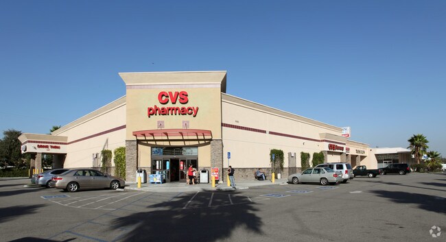
Property Record
11021 Alondra Blvd, Norwalk, CA 90650

NEARBY LISTINGS FOR SALE OR LEASE
Property Detail
11021 Alondra Blvd
Los Angeles-Long Beach-Glendale, CA
Rancho Los Coyotes
8078-018-026
RANCHO LOS COYOTES SECTIONS TOWNSHIP AND RANGE AS PER PATENTS BK 1 PG 493-494 AND O R M 7425 PG 20-21 E 350 FT OF S 310 FT OF SW 1/4 OF SW 1/4 OF SW 1/4 EX OF ST OF SEC 24 T 3S R 12W
Regionalshoppingcenterormallwithanchorstore
Los Angeles
X
California
06037C1840F
24
2024
1.18 AC
2025
Mid-Cities
552900
Los Angeles
14,504 SF
DEMOGRAPHICS near 11021 Alondra Blvd
1 Mile
3 Mile
5 Mile
2024 Total Population
25,405
253,770
630,261
2029 Population
24,522
244,969
608,588
Pop Growth 2024-2029
(3.48%)
(3.47%)
(3.44%)
Average Age
39
39
39
2024 Total Households
7,231
74,620
187,472
HH Growth 2024-2029
(3.73%)
(3.71%)
(3.68%)
Median Household Inc
$84,338
$84,038
$85,269
Avg Household Size
3.40
3.30
3.20
2024 Avg HH Vehicles
3.00
2.00
2.00
Median Home Value
$680,198
$679,611
$701,290
Median Year Built
1958
1961
1960
Nearby Places
Map Layers
Map Styles
 Street
 Aerial
- Restaurants
- Banks
- Shops
- Fitness
- Groceries
PUBLIC TRANSPORTATION
COMMUTER RAIL
Norwalk/Santa Fe Springs (91 Line - Southern California Regional Rail Authority (Metrolink), Orange County Line - Southern California Regional Rail Authority (Metrolink))
DRIVE
WALK
Distance
Norwalk/Santa Fe Springs (91 Line - Southern California Regional Rail Authority (Metrolink), Orange County Line - Southern California Regional Rail Authority (Metrolink))
8 min
4.1 mi
Buena Park (91 Line - Southern California Regional Rail Authority (Metrolink), Orange County Line - Southern California Regional Rail Authority (Metrolink))
DRIVE
WALK
Distance
Buena Park (91 Line - Southern California Regional Rail Authority (Metrolink), Orange County Line - Southern California Regional Rail Authority (Metrolink))
14 min
7.2 mi
AIRPORT
Long Beach (Daugherty Field)
DRIVE
WALK
Distance
Long Beach (Daugherty Field)
17 min
9.6 mi
Los Angeles International
DRIVE
WALK
Distance
Los Angeles International
29 min
21.6 mi
John Wayne/Orange County
DRIVE
WALK
Distance
John Wayne/Orange County
31 min
23.9 mi
Freight Ports
Port of Long Beach
DRIVE
WALK
Distance
Port of Long Beach
24 min
15.4 mi
Nearby Properties
Address
Land Use
TOTAL SIZE
Lot Size
Zoning
Address
Land Use
TOTAL SIZE
Lot Size
Zoning
1,339,758 SF
28.53 AC
DOM2-P*
Address
Land Use
TOTAL SIZE
Lot Size
Zoning
324,400 SF
55.03 AC
CECR
Address
Land Use
TOTAL SIZE
Lot Size
Zoning
634,060 SF
76.06 AC
SSM2
Address
Land Use
TOTAL SIZE
Lot Size
Zoning
383,495 SF
11.60 AC
DOR3PUD*
Address
Land Use
TOTAL SIZE
Lot Size
Zoning
730,731 SF
14.89 AC
BFCG*
Address
Land Use
TOTAL SIZE
Lot Size
Zoning
353,001 SF
4.81 AC
CEM
Address
Land Use
TOTAL SIZE
Lot Size
Zoning
166,712 SF
8.53 AC
NOM1(PF)-P
Address
Land Use
TOTAL SIZE
Lot Size
Zoning
371,464 SF
9.28 AC
DOM2-P*
Address
Land Use
TOTAL SIZE
Lot Size
Zoning
518,296 SF
13.94 AC
NOCO(PF)*
Address
Land Use
TOTAL SIZE
Lot Size
Zoning
266,337 SF
2.40 AC
CE-ADP-16
Address
Land Use
TOTAL SIZE
Lot Size
Zoning
247,536 SF
5.79 AC
CECR
Address
Land Use
TOTAL SIZE
Lot Size
Zoning
124,820 SF
4.11 AC
NOM2*
Address
Land Use
TOTAL SIZE
Lot Size
Zoning
161,650 SF
6 AC
CEM(D1)*
Address
Land Use
TOTAL SIZE
Lot Size
Zoning
300,102 SF
11.94 AC
SSM2*
Address
Land Use
TOTAL SIZE
Lot Size
Zoning
145,520 SF
6.64 AC
CEADP1
Address
Land Use
TOTAL SIZE
Lot Size
Zoning
106,028 SF
6.42 AC
DOM2-P*
Address
Land Use
TOTAL SIZE
Lot Size
Zoning
64,160 SF
6.62 AC
CEADP1
Address
Land Use
TOTAL SIZE
Lot Size
Zoning
138,944 SF
2.03 AC
NOSPA1*
Address
Land Use
TOTAL SIZE
Lot Size
Zoning
140,624 SF
4.35 AC
ATMRV1200*
Address
Land Use
TOTAL SIZE
Lot Size
Zoning
99,674 SF
6.53 AC
DOM2-P*
Address
Land Use
TOTAL SIZE
Lot Size
Zoning
99,238 SF
3.49 AC
NOR3YY
Address
Land Use
TOTAL SIZE
Lot Size
Zoning
131,066 SF
9.45 AC
NOM1-P*
Address
Land Use
TOTAL SIZE
Lot Size
Zoning
1,004,620 SF
19.73 AC
CECR
Address
Land Use
TOTAL SIZE
Lot Size
Zoning
102,680 SF
4.43 AC
CEADP1
Address
Land Use
TOTAL SIZE
Lot Size
Zoning
132,019 SF
5.22 AC
LKMFR*
Address
Land Use
TOTAL SIZE
Lot Size
Zoning
70,210 SF
3.14 AC
SSM1-BP*
Address
Land Use
TOTAL SIZE
Lot Size
Zoning
290,000 SF
11.83 AC
CEADP1
Address
Land Use
TOTAL SIZE
Lot Size
Zoning
181,405 SF
4.57 AC
NOC3VV
Address
Land Use
TOTAL SIZE
Lot Size
Zoning
80,339 SF
5.88 AC
ATCPD*
Address
Land Use
TOTAL SIZE
Lot Size
Zoning
511,188 SF
20.77 AC
SSM2*
The World's #1 Commercial Real Estate Marketplace
Connect with us
© 2025 CoStar Group
The information above has been obtained from sources believed reliable. While we do not doubt its accuracy we have not verified it and make no guarantee, warranty or representation about it. It is your responsibility to independently confirm its accuracy and completeness. Any projections, opinions, assumptions, or estimates used are for example only and do not represent the current or future performance of the property. The value of this transaction to you depends on tax and other factors which should be evaluated by your tax, financial, and legal advisors. You and your advisors should conduct a careful, independent investigation of the property to determine to your satisfaction the suitability of the property for your needs.