Property Record
11022 Culebra Rd, San Antonio, TX 78253
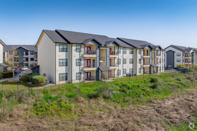

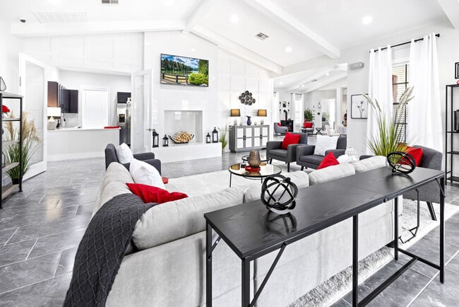
Property Detail
11022 Culebra Rd
San Antonio-New Braunfels, TX
CB 4415B BLK 6 LOT 10 (WESTWINDS COMMERCIAL UT-3A3) 2014-NEW ACCT PER SPLIT PER PLAT 9653/196-199 FILED 4/5/2013
04415-206-0100
BEXAR
Multifamilydwelling
Texas
B and X Area of moderate flood hazard, usually the area between the limits of the 100-year and 500-year floods.
10
2024
11.28 AC
2025
Far West Side
172005
San Antonio
161,790 SF
NEARBY LISTINGS FOR SALE OR LEASE
-
-
View all San Antonio listings for sale on LoopNet.com
DEMOGRAPHICS near 11022 Culebra Rd
1 mile
3 mile
5 mile
2025 Total Population
14,061
111,346
273,691
2030 Population
14,927
117,058
288,540
Pop Growth 2025-2030
+ 6.16%
+ 5.13%
+ 5.43%
Average Age
34
35
36
2025 Total Households
5,184
37,790
93,008
HH Growth 2025-2030
+ 6.37%
+ 5.30%
+ 5.47%
Median Household Inc
$74,301
$92,108
$95,352
Avg Household Size
2.70
2.90
2.90
2025 Avg HH Vehicles
2.00
2.00
2.00
Median Home Value
$329,287
$294,745
$302,000
Median Year Built
2010
2005
2003
Nearby Places
Map Layers
Map Styles
 Street
 Aerial
Layers
 Traffic
 Biking
Places
Listings with unknown addresses are not visible on the map
- Restaurants
- Banks
- Shops
- Fitness
- Groceries
PUBLIC TRANSPORTATION
AIRPORT
San Antonio International
Drive
Walk
Distance
San Antonio International
25 min
16.7 mi
Nearby Properties
Address
Land Use
TOTAL SIZE
Lot Size
Zoning
Address
Land Use
TOTAL SIZE
Lot Size
Zoning
754,713 SF
33.44 AC
Address
Land Use
TOTAL SIZE
Lot Size
Zoning
486,228 SF
50.05 AC
Address
Land Use
TOTAL SIZE
Lot Size
Zoning
315,000 SF
24.20 AC
Address
Land Use
TOTAL SIZE
Lot Size
Zoning
1,963,350 SF
36.24 AC
Address
Land Use
TOTAL SIZE
Lot Size
Zoning
738,286 SF
44 SF
Address
Land Use
TOTAL SIZE
Lot Size
Zoning
469,808 SF
36 AC
Address
Land Use
TOTAL SIZE
Lot Size
Zoning
443,726 SF
25.01 AC
Address
Land Use
TOTAL SIZE
Lot Size
Zoning
257,232 SF
66.01 AC
Address
Land Use
TOTAL SIZE
Lot Size
Zoning
321,368 SF
48.21 AC
Address
Land Use
TOTAL SIZE
Lot Size
Zoning
411,503 SF
48.90 AC
Address
Land Use
TOTAL SIZE
Lot Size
Zoning
304,232 SF
99.80 AC
Address
Land Use
TOTAL SIZE
Lot Size
Zoning
185,751 SF
21.60 AC
Address
Land Use
TOTAL SIZE
Lot Size
Zoning
171,142 SF
21.60 AC
Address
Land Use
TOTAL SIZE
Lot Size
Zoning
260,384 SF
33.56 AC
Address
Land Use
TOTAL SIZE
Lot Size
Zoning
352,500 SF
31.03 AC
Address
Land Use
TOTAL SIZE
Lot Size
Zoning
299,142 SF
22 AC
Address
Land Use
TOTAL SIZE
Lot Size
Zoning
276,500 SF
15.51 AC
Address
Land Use
TOTAL SIZE
Lot Size
Zoning
342,773 SF
19.58 AC
Address
Land Use
TOTAL SIZE
Lot Size
Zoning
408,011 SF
43.98 AC
Address
Land Use
TOTAL SIZE
Lot Size
Zoning
815,030 SF
111.97 AC
Address
Land Use
TOTAL SIZE
Lot Size
Zoning
123,595 SF
21.60 AC
Address
Land Use
TOTAL SIZE
Lot Size
Zoning
316,842 SF
19.61 AC
Address
Land Use
TOTAL SIZE
Lot Size
Zoning
608,644 SF
88.50 AC
Address
Land Use
TOTAL SIZE
Lot Size
Zoning
149,500 SF
9.36 AC
Address
Land Use
TOTAL SIZE
Lot Size
Zoning
268,511 SF
16.95 AC
Address
Land Use
TOTAL SIZE
Lot Size
Zoning
299,795 SF
16.13 AC
Address
Land Use
TOTAL SIZE
Lot Size
Zoning
294,979 SF
18.70 AC
Address
Land Use
TOTAL SIZE
Lot Size
Zoning
268,790 SF
12.47 AC
Address
Land Use
TOTAL SIZE
Lot Size
Zoning
268,165 SF
14.84 AC
Address
Land Use
TOTAL SIZE
Lot Size
Zoning
281,880 SF
14.13 AC
The World's #1 Commercial Real Estate Marketplace
Connect with us
© 2026 CoStar Group
The information above has been obtained from sources believed reliable. While we do not doubt its accuracy we have not verified it and make no guarantee, warranty or representation about it. It is your responsibility to independently confirm its accuracy and completeness. Any projections, opinions, assumptions, or estimates used are for example only and do not represent the current or future performance of the property. The value of this transaction to you depends on tax and other factors which should be evaluated by your tax, financial, and legal advisors. You and your advisors should conduct a careful, independent investigation of the property to determine to your satisfaction the suitability of the property for your needs.