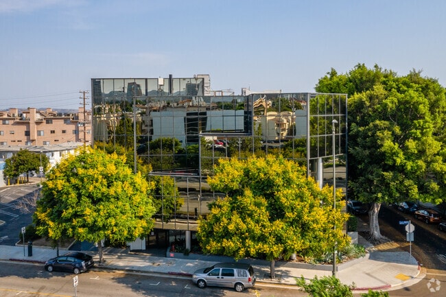
Property Record
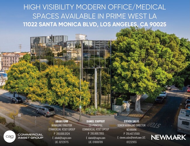
11022 Santa Monica Blvd, Los Angeles, CA 90025

Current Lease Availabilities
NEARBY LISTINGS FOR SALE OR LEASE
Property Detail
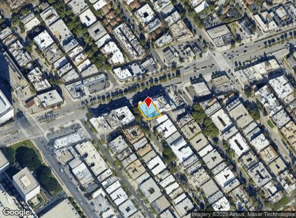
11022 Santa Monica Blvd
Los Angeles-Long Beach-Glendale, CA
5609
4323-013-163
*TR=5609*(EX OF STS) LOT 6 AND ALL OF LOT 5 BLK 11
Officebuilding
Los Angeles
X
California
06037C1590G
6,5
2024
0.25 AC
2025
Westwood
267201
Los Angeles
27,203 SF
DEMOGRAPHICS near 11022 Santa Monica Blvd
1 Mile
3 Mile
5 Mile
2024 Total Population
48,990
299,318
635,516
2029 Population
48,383
294,526
623,464
Pop Growth 2024-2029
(1.24%)
(1.60%)
(1.90%)
Average Age
40
39
41
2024 Total Households
23,538
129,763
288,543
HH Growth 2024-2029
(1.38%)
(1.78%)
(2.06%)
Median Household Inc
$98,662
$102,168
$104,085
Avg Household Size
2.00
2.10
2.10
2024 Avg HH Vehicles
1.00
1.00
2.00
Median Home Value
$1,044,183
$1,104,240
$1,103,192
Median Year Built
1975
1970
1968
Nearby Places
- Restaurants
- Banks
- Shops
- Fitness
- Groceries
PUBLIC TRANSPORTATION
AIRPORT
Los Angeles International
DRIVE
WALK
Distance
Los Angeles International
16 min
9.6 mi
Bob Hope
DRIVE
WALK
Distance
Bob Hope
27 min
18.1 mi
Long Beach (Daugherty Field)
DRIVE
WALK
Distance
Long Beach (Daugherty Field)
35 min
27.0 mi
Freight Ports
Port of Long Beach
DRIVE
WALK
Distance
Port of Long Beach
38 min
28.9 mi
Nearby Properties
Address
Land Use
TOTAL SIZE
Lot Size
Zoning
Address
Land Use
TOTAL SIZE
Lot Size
Zoning
1,436,724 SF
21.11 AC
LAC2
Address
Land Use
TOTAL SIZE
Lot Size
Zoning
486,993 SF
8.31 AC
SMCP3-CP5*
Address
Land Use
TOTAL SIZE
Lot Size
Zoning
45,135 SF
1.69 AC
LARE9
Address
Land Use
TOTAL SIZE
Lot Size
Zoning
1,509,050 SF
113.39 AC
LAA1
Address
Land Use
TOTAL SIZE
Lot Size
Zoning
3.47 AC
LARE15
Address
Land Use
TOTAL SIZE
Lot Size
Zoning
0.29 AC
LARE
Address
Land Use
TOTAL SIZE
Lot Size
Zoning
597,158 SF
2.15 AC
LAC2
Address
Land Use
TOTAL SIZE
Lot Size
Zoning
1,353,044 SF
6.18 AC
LAC2
Address
Land Use
TOTAL SIZE
Lot Size
Zoning
227,227 SF
7.62 AC
BHC3*
Address
Land Use
TOTAL SIZE
Lot Size
Zoning
5.57 AC
LAC2
Address
Land Use
TOTAL SIZE
Lot Size
Zoning
33,373 SF
52.98 AC
LACCS
Address
Land Use
TOTAL SIZE
Lot Size
Zoning
1,029,337 SF
3.34 AC
LAC4
Address
Land Use
TOTAL SIZE
Lot Size
Zoning
618,301 SF
1.99 AC
LAC4
Address
Land Use
TOTAL SIZE
Lot Size
Zoning
840,124 SF
2.77 AC
LAC2
Address
Land Use
TOTAL SIZE
Lot Size
Zoning
318,556 SF
3.19 AC
SMC5*
Address
Land Use
TOTAL SIZE
Lot Size
Zoning
636,436 SF
6.62 AC
LAC2
Address
Land Use
TOTAL SIZE
Lot Size
Zoning
500,629 SF
1.60 AC
LAC4
Address
Land Use
TOTAL SIZE
Lot Size
Zoning
366,614 SF
4.25 AC
LAC4
Address
Land Use
TOTAL SIZE
Lot Size
Zoning
803,989 SF
LAC2
Address
Land Use
TOTAL SIZE
Lot Size
Zoning
1,232,625 SF
2.40 AC
LAC2
Address
Land Use
TOTAL SIZE
Lot Size
Zoning
1,226,598 SF
2.30 AC
LAC2
Address
Land Use
TOTAL SIZE
Lot Size
Zoning
32,180 SF
BHC3*
Address
Land Use
TOTAL SIZE
Lot Size
Zoning
824,156 SF
2.15 AC
LAC2
Address
Land Use
TOTAL SIZE
Lot Size
Zoning
767,078 SF
9.30 AC
LAC2
Address
Land Use
TOTAL SIZE
Lot Size
Zoning
133,959 SF
1.23 AC
BHC3*
Address
Land Use
TOTAL SIZE
Lot Size
Zoning
858,380 SF
7.23 AC
SMC5*
Address
Land Use
TOTAL SIZE
Lot Size
Zoning
605,678 SF
LAC2
Address
Land Use
TOTAL SIZE
Lot Size
Zoning
808,626 SF
1.88 AC
LAC2
Address
Land Use
TOTAL SIZE
Lot Size
Zoning
35,635 SF
2.81 AC
LAC2
Address
Land Use
TOTAL SIZE
Lot Size
Zoning
483,875 SF
7.31 AC
SMC5*
The World's #1 Commercial Real Estate Marketplace
Connect with us
© 2025 CoStar Group
The information above has been obtained from sources believed reliable. While we do not doubt its accuracy we have not verified it and make no guarantee, warranty or representation about it. It is your responsibility to independently confirm its accuracy and completeness. Any projections, opinions, assumptions, or estimates used are for example only and do not represent the current or future performance of the property. The value of this transaction to you depends on tax and other factors which should be evaluated by your tax, financial, and legal advisors. You and your advisors should conduct a careful, independent investigation of the property to determine to your satisfaction the suitability of the property for your needs.