Property Record
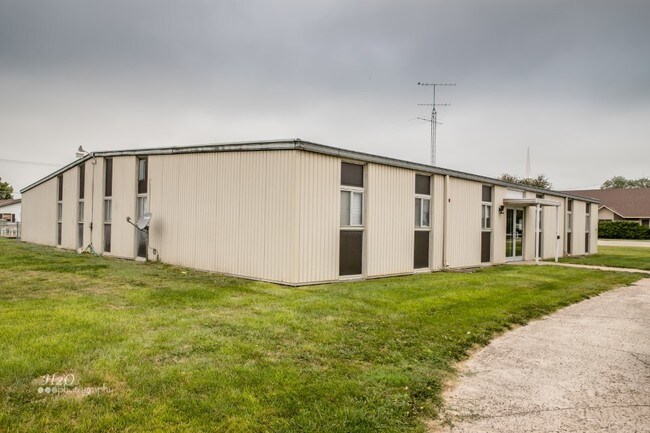
1103 Central St, Oxford, NE 68967


NEARBY LISTINGS FOR SALE OR LEASE
-
-
View all Oxford listings for sale on LoopNet.com
Property Detail
1103 Central St
457800
Lueking 76 Add
Commercialnec
EAST PT OF LT 3 BLK 2 LUEKING '76 ADD OXFORD
X
Furnas
31065C0125C
Nebraska
2024
3
2025
0.56 AC
963900
Nebraska Area
6,240 SF
Other Market Areas
DEMOGRAPHICS near 1103 Central St
1 Mile
3 Mile
5 Mile
2024 Total Population
680
734
826
2029 Population
663
716
805
Pop Growth 2024-2029
(2.50%)
(2.45%)
(2.54%)
Average Age
43
43
43
2024 Total Households
312
336
376
HH Growth 2024-2029
(2.56%)
(2.38%)
(2.39%)
Median Household Inc
$54,166
$54,359
$54,880
Avg Household Size
2.20
2.20
2.20
2024 Avg HH Vehicles
3.00
3.00
3.00
Median Home Value
$131,111
$129,592
$129,464
Median Year Built
1950
1950
1950
Nearby Places
Map Layers
Map Styles
 Street
 Aerial
- Restaurants
- Banks
- Shops
- Fitness
- Groceries
SALE & LEASE HISTORY
LISTING DATE
SALE/LEASE

Sep 21, 2020
For Sale
Sep 10, 2019
For Sale
Nearby Properties
Address
Land Use
TOTAL SIZE
Lot Size
Zoning
Address
Land Use
TOTAL SIZE
Lot Size
Zoning
7,000 SF
9.98 AC
COMMERCIAL
Address
Land Use
TOTAL SIZE
Lot Size
Zoning
325 AC
AGRICULTUR
Address
Land Use
TOTAL SIZE
Lot Size
Zoning
320 AC
AGRICULTUR
Address
Land Use
TOTAL SIZE
Lot Size
Zoning
309 AC
05-AGRICUL
Address
Land Use
TOTAL SIZE
Lot Size
Zoning
3,840 SF
152 AC
AGRICULTUR
Address
Land Use
TOTAL SIZE
Lot Size
Zoning
1,208 SF
155 AC
AGRICULTUR
Address
Land Use
TOTAL SIZE
Lot Size
Zoning
160 AC
AGRICULTUR
Address
Land Use
TOTAL SIZE
Lot Size
Zoning
226 AC
AGRICULTUR
Address
Land Use
TOTAL SIZE
Lot Size
Zoning
144 AC
AGRICULTUR
Address
Land Use
TOTAL SIZE
Lot Size
Zoning
159 AC
AGRICULTUR
Address
Land Use
TOTAL SIZE
Lot Size
Zoning
159 AC
AGRICULTUR
Address
Land Use
TOTAL SIZE
Lot Size
Zoning
162 AC
AGRICULTUR
Address
Land Use
TOTAL SIZE
Lot Size
Zoning
204 AC
AGRICULTUR
Address
Land Use
TOTAL SIZE
Lot Size
Zoning
299 AC
AGRICULTUR
Address
Land Use
TOTAL SIZE
Lot Size
Zoning
162 AC
05-AGRICUL
Address
Land Use
TOTAL SIZE
Lot Size
Zoning
122 AC
AGRICULTUR
Address
Land Use
TOTAL SIZE
Lot Size
Zoning
152 AC
AGRICULTUR
Address
Land Use
TOTAL SIZE
Lot Size
Zoning
160 AC
AGRICULTUR
Address
Land Use
TOTAL SIZE
Lot Size
Zoning
154 AC
05-AGRICUL
Address
Land Use
TOTAL SIZE
Lot Size
Zoning
220 AC
05-AGRICUL
Address
Land Use
TOTAL SIZE
Lot Size
Zoning
7,658 SF
0.64 AC
03-COMMERC
Address
Land Use
TOTAL SIZE
Lot Size
Zoning
6,000 SF
2 AC
03-COMMERC
Address
Land Use
TOTAL SIZE
Lot Size
Zoning
109 AC
AGRICULTUR
Address
Land Use
TOTAL SIZE
Lot Size
Zoning
239 AC
AGRICULTUR
Address
Land Use
TOTAL SIZE
Lot Size
Zoning
158 AC
AGRICULTUR
Address
Land Use
TOTAL SIZE
Lot Size
Zoning
148 AC
AGRICULTUR
Address
Land Use
TOTAL SIZE
Lot Size
Zoning
157 AC
AGRICULTUR
Address
Land Use
TOTAL SIZE
Lot Size
Zoning
161 AC
AGRICULTUR
Address
Land Use
TOTAL SIZE
Lot Size
Zoning
80 AC
AGRICULTUR
Address
Land Use
TOTAL SIZE
Lot Size
Zoning
123 AC
AGRICULTUR
The World's #1 Commercial Real Estate Marketplace
Connect with us
© 2026 CoStar Group
The information above has been obtained from sources believed reliable. While we do not doubt its accuracy we have not verified it and make no guarantee, warranty or representation about it. It is your responsibility to independently confirm its accuracy and completeness. Any projections, opinions, assumptions, or estimates used are for example only and do not represent the current or future performance of the property. The value of this transaction to you depends on tax and other factors which should be evaluated by your tax, financial, and legal advisors. You and your advisors should conduct a careful, independent investigation of the property to determine to your satisfaction the suitability of the property for your needs.