Property Record
Harrisburg Rd, Fort Mill, SC 29707
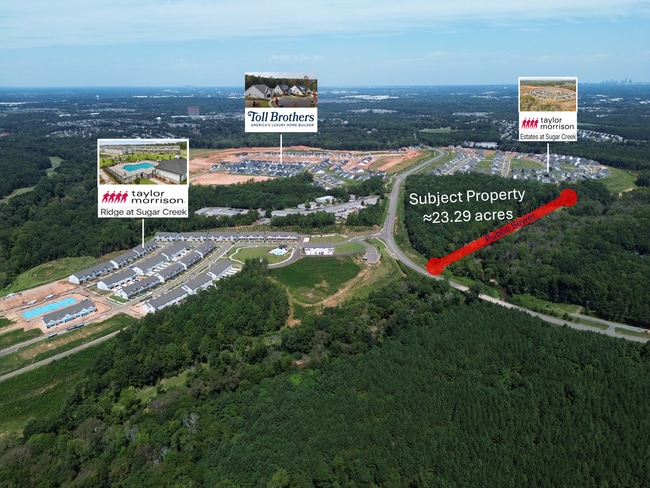
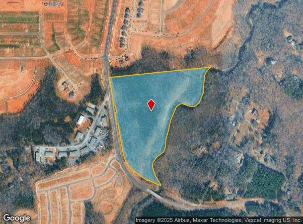
This Property Is For Sale
NEARBY LISTINGS FOR SALE OR LEASE
Property Detail
Harrisburg Rd
Charlotte-Concord-Gastonia, NC-SC
Property Of Zepsa Properties Llc
0003-00-006.03
ZESPA PROPERTIES, LLC
Commercialnec
Lancaster
AE
South Carolina
45057C0017E
23.29 AC
2024
Lancaster County
2024
Charlotte
011205
DEMOGRAPHICS near Harrisburg Rd
1 Mile
3 Mile
5 Mile
2024 Total Population
3,533
60,568
154,731
2029 Population
4,086
66,923
170,047
Pop Growth 2024-2029
+ 15.65%
+ 10.49%
+ 9.90%
Average Age
36
38
38
2024 Total Households
1,226
23,261
60,312
HH Growth 2024-2029
+ 15.74%
+ 10.40%
+ 9.78%
Median Household Inc
$124,636
$99,319
$99,554
Avg Household Size
2.90
2.60
2.50
2024 Avg HH Vehicles
2.00
2.00
2.00
Median Home Value
$403,571
$361,412
$385,378
Median Year Built
2010
2004
2000
Nearby Places
- Restaurants
- Banks
- Shops
- Fitness
- Groceries
PUBLIC TRANSPORTATION
AIRPORT
Charlotte/Douglas International
DRIVE
WALK
Distance
Charlotte/Douglas International
27 min
14.8 mi
Concord-Padgett Regional
DRIVE
WALK
Distance
Concord-Padgett Regional
48 min
37.8 mi
Freight Ports
North Charleston Terminal
DRIVE
WALK
Distance
North Charleston Terminal
217 min
189.4 mi
Nearby Properties
Address
Land Use
TOTAL SIZE
Lot Size
Zoning
Address
Land Use
TOTAL SIZE
Lot Size
Zoning
922,476 SF
49.91 AC
BP
Address
Land Use
TOTAL SIZE
Lot Size
Zoning
244,692 SF
264.29 AC
I2
Address
Land Use
TOTAL SIZE
Lot Size
Zoning
605,542 SF
586.46 AC
Address
Land Use
TOTAL SIZE
Lot Size
Zoning
720,470 SF
5.45 AC
Address
Land Use
TOTAL SIZE
Lot Size
Zoning
425,591 SF
31.58 AC
MX1
Address
Land Use
TOTAL SIZE
Lot Size
Zoning
361,910 SF
3.60 AC
Address
Land Use
TOTAL SIZE
Lot Size
Zoning
465,462 SF
23.76 AC
CC
Address
Land Use
TOTAL SIZE
Lot Size
Zoning
294,279 SF
27.77 AC
R12MFCD
Address
Land Use
TOTAL SIZE
Lot Size
Zoning
215,600 SF
6.97 AC
R3
Address
Land Use
TOTAL SIZE
Lot Size
Zoning
3,183 SF
3.82 AC
Address
Land Use
TOTAL SIZE
Lot Size
Zoning
348,409 SF
26.08 AC
R17MFCD
Address
Land Use
TOTAL SIZE
Lot Size
Zoning
287,004 SF
14.52 AC
R3
Address
Land Use
TOTAL SIZE
Lot Size
Zoning
321,129 SF
23.59 AC
MX2
Address
Land Use
TOTAL SIZE
Lot Size
Zoning
279,674 SF
18.28 AC
CC
Address
Land Use
TOTAL SIZE
Lot Size
Zoning
518,080 SF
5.44 AC
Address
Land Use
TOTAL SIZE
Lot Size
Zoning
293,128 SF
22.70 AC
MX2
Address
Land Use
TOTAL SIZE
Lot Size
Zoning
497,462 SF
5.64 AC
BPCD
Address
Land Use
TOTAL SIZE
Lot Size
Zoning
497,462 SF
6.32 AC
BPCD
Address
Land Use
TOTAL SIZE
Lot Size
Zoning
195,262 SF
4.56 AC
Address
Land Use
TOTAL SIZE
Lot Size
Zoning
236,862 SF
30.19 AC
CC
Address
Land Use
TOTAL SIZE
Lot Size
Zoning
186,651 SF
7.40 AC
CC
Address
Land Use
TOTAL SIZE
Lot Size
Zoning
549,017 SF
486.09 AC
Address
Land Use
TOTAL SIZE
Lot Size
Zoning
234,912 SF
11.60 AC
R3
Address
Land Use
TOTAL SIZE
Lot Size
Zoning
221,152 SF
15.87 AC
MX2
Address
Land Use
TOTAL SIZE
Lot Size
Zoning
157,468 SF
15.84 AC
CC
Address
Land Use
TOTAL SIZE
Lot Size
Zoning
226,602 SF
13.89 AC
BPCD
Address
Land Use
TOTAL SIZE
Lot Size
Zoning
211,609 SF
6.91 AC
UR2CD
Address
Land Use
TOTAL SIZE
Lot Size
Zoning
216,222 SF
21.81 AC
RMF
Address
Land Use
TOTAL SIZE
Lot Size
Zoning
227,264 SF
21.77 AC
RMF
Address
Land Use
TOTAL SIZE
Lot Size
Zoning
170,443 SF
13.77 AC
MUDD-O
The World's #1 Commercial Real Estate Marketplace
Connect with us
© 2025 CoStar Group
The information above has been obtained from sources believed reliable. While we do not doubt its accuracy we have not verified it and make no guarantee, warranty or representation about it. It is your responsibility to independently confirm its accuracy and completeness. Any projections, opinions, assumptions, or estimates used are for example only and do not represent the current or future performance of the property. The value of this transaction to you depends on tax and other factors which should be evaluated by your tax, financial, and legal advisors. You and your advisors should conduct a careful, independent investigation of the property to determine to your satisfaction the suitability of the property for your needs.