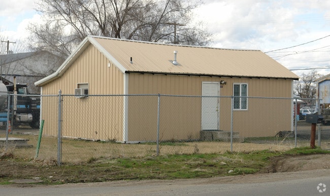
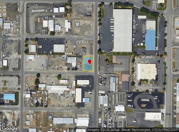
Property Record
1103 N Howe Rd, Spokane Valley, WA 99212

NEARBY LISTINGS FOR SALE OR LEASE
Property Detail
1103 N Howe Rd
Spokane-Spokane Valley, WA
Yardley-Town
35141.1318
YARDLEY-TOWN OF ALL LT 1 & LT 2 EXC W10 BLK 16 TOG W/ S1/2 VAC ALLEY LYG N & ADJ TO SD LTS
Vacantlandnec
Spokane
X
Washington
53063C0562D
1,2
2025
0.28 AC
2025
Valley
012200
Spokane
592 SF
DEMOGRAPHICS near 1103 N Howe Rd
1 Mile
3 Mile
5 Mile
2024 Total Population
2,261
65,862
226,282
2029 Population
2,407
70,087
240,962
Pop Growth 2024-2029
+ 6.46%
+ 6.41%
+ 6.49%
Average Age
36
39
39
2024 Total Households
1,046
26,160
93,433
HH Growth 2024-2029
+ 6.41%
+ 6.56%
+ 6.76%
Median Household Inc
$43,113
$60,934
$57,840
Avg Household Size
2.20
2.40
2.30
2024 Avg HH Vehicles
2.00
2.00
2.00
Median Home Value
$147,457
$279,630
$314,214
Median Year Built
1993
1970
1971
Nearby Places
Map Layers
Map Styles
 Street
 Aerial
- Restaurants
- Banks
- Shops
- Fitness
- Groceries
PUBLIC TRANSPORTATION
COMMUTER RAIL
Spokane (Empire Builder - Amtrak)
DRIVE
WALK
Distance
Spokane (Empire Builder - Amtrak)
10 min
5.5 mi
AIRPORT
Spokane International
DRIVE
WALK
Distance
Spokane International
17 min
11.4 mi
Freight Ports
Port of Everett
DRIVE
WALK
Distance
Port of Everett
345 min
307.0 mi
Nearby Properties
Address
Land Use
TOTAL SIZE
Lot Size
Zoning
Address
Land Use
TOTAL SIZE
Lot Size
Zoning
917,113 SF
100.67 AC
LI
Address
Land Use
TOTAL SIZE
Lot Size
Zoning
365,804 SF
16.13 AC
RSF
Address
Land Use
TOTAL SIZE
Lot Size
Zoning
427,054 SF
16.60 AC
LI
Address
Land Use
TOTAL SIZE
Lot Size
Zoning
251,542 SF
5.78 AC
DTG
Address
Land Use
TOTAL SIZE
Lot Size
Zoning
310,606 SF
27.56 AC
RMF
Address
Land Use
TOTAL SIZE
Lot Size
Zoning
355,192 SF
35.83 AC
I-2
Address
Land Use
TOTAL SIZE
Lot Size
Zoning
379,678 SF
20.64 AC
LI
Address
Land Use
TOTAL SIZE
Lot Size
Zoning
378,750 SF
17.38 AC
R-2
Address
Land Use
TOTAL SIZE
Lot Size
Zoning
91,310 SF
2.34 AC
Address
Land Use
TOTAL SIZE
Lot Size
Zoning
108,237 SF
3.48 AC
LI
Address
Land Use
TOTAL SIZE
Lot Size
Zoning
58,522 SF
19.91 AC
HI
Address
Land Use
TOTAL SIZE
Lot Size
Zoning
134,806 SF
7.79 AC
RMF
Address
Land Use
TOTAL SIZE
Lot Size
Zoning
96,424 SF
9.04 AC
I-1
Address
Land Use
TOTAL SIZE
Lot Size
Zoning
75,680 SF
3.93 AC
RSF
Address
Land Use
TOTAL SIZE
Lot Size
Zoning
107,442 SF
5.57 AC
MF-2
Address
Land Use
TOTAL SIZE
Lot Size
Zoning
47,612 SF
3.38 AC
CMU
Address
Land Use
TOTAL SIZE
Lot Size
Zoning
134,104 SF
5.89 AC
HDR
Address
Land Use
TOTAL SIZE
Lot Size
Zoning
150,812 SF
17.49 AC
RC
Address
Land Use
TOTAL SIZE
Lot Size
Zoning
107,539 SF
7.54 AC
RMF
Address
Land Use
TOTAL SIZE
Lot Size
Zoning
50,179 SF
5.54 AC
RSF
Address
Land Use
TOTAL SIZE
Lot Size
Zoning
102,441 SF
8.38 AC
Address
Land Use
TOTAL SIZE
Lot Size
Zoning
118,818 SF
7.96 AC
HDR
Address
Land Use
TOTAL SIZE
Lot Size
Zoning
138,078 SF
8.44 AC
HI
Address
Land Use
TOTAL SIZE
Lot Size
Zoning
60,484 SF
2.38 AC
LI
Address
Land Use
TOTAL SIZE
Lot Size
Zoning
91,811 SF
6.02 AC
LI
Address
Land Use
TOTAL SIZE
Lot Size
Zoning
71,803 SF
2.34 AC
RMF
Address
Land Use
TOTAL SIZE
Lot Size
Zoning
68,600 SF
5.25 AC
MF-2
Address
Land Use
TOTAL SIZE
Lot Size
Zoning
104,760 SF
6.96 AC
HDR
Address
Land Use
TOTAL SIZE
Lot Size
Zoning
38,889 SF
114.18 AC
LI
Address
Land Use
TOTAL SIZE
Lot Size
Zoning
200 SF
159.15 AC
LI
The World's #1 Commercial Real Estate Marketplace
Connect with us
© 2025 CoStar Group
The information above has been obtained from sources believed reliable. While we do not doubt its accuracy we have not verified it and make no guarantee, warranty or representation about it. It is your responsibility to independently confirm its accuracy and completeness. Any projections, opinions, assumptions, or estimates used are for example only and do not represent the current or future performance of the property. The value of this transaction to you depends on tax and other factors which should be evaluated by your tax, financial, and legal advisors. You and your advisors should conduct a careful, independent investigation of the property to determine to your satisfaction the suitability of the property for your needs.