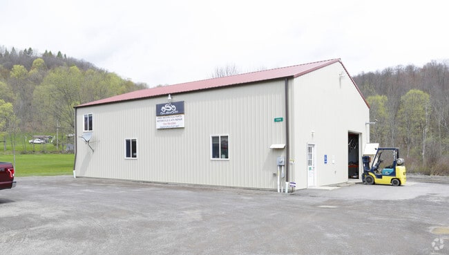
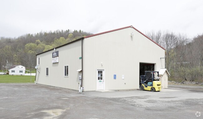
Property Record
11034 State Route 85, Kittanning, PA 16201
NEARBY LISTINGS FOR SALE OR LEASE
-
-
View all Kittanning listings for lease on LoopNet.com
Property Detail
11034 State Route 85
46-0-069711
Wayne H Barker Subdivision
Vacantlandnec
Armstrong
X
Pennsylvania
42005C0345D
1 AC
2025
Armstrong County
2025
Pittsburgh
950600
Pittsburgh, PA
DEMOGRAPHICS near 11034 State Route 85
1 Mile
3 Mile
5 Mile
2024 Total Population
86
1,667
5,501
2029 Population
85
1,631
5,341
Pop Growth 2024-2029
(1.16%)
(2.16%)
(2.91%)
Average Age
44
45
45
2024 Total Households
33
675
2,280
HH Growth 2024-2029
0.00%
(2.22%)
(3.03%)
Median Household Inc
$52,500
$65,208
$61,567
Avg Household Size
2.30
2.30
2.30
2024 Avg HH Vehicles
2.00
2.00
2.00
Median Home Value
$141,666
$168,713
$158,762
Median Year Built
1957
1969
1966
Nearby Places
Map Layers
Map Styles
 Street
 Aerial
- Restaurants
- Banks
- Shops
- Fitness
- Groceries
SALE & LEASE HISTORY
LISTING DATE
SALE/LEASE

May 25, 2017
For Lease
Apr 27, 2017
For Sale
Nearby Properties
Address
Land Use
TOTAL SIZE
Lot Size
Zoning
Address
Land Use
TOTAL SIZE
Lot Size
Zoning
10,330 SF
1.01 AC
Address
Land Use
TOTAL SIZE
Lot Size
Zoning
3,696 SF
12.30 AC
Address
Land Use
TOTAL SIZE
Lot Size
Zoning
1,920 SF
5.41 AC
Address
Land Use
TOTAL SIZE
Lot Size
Zoning
25,200 SF
5.29 AC
Address
Land Use
TOTAL SIZE
Lot Size
Zoning
5,700 SF
13.86 AC
Address
Land Use
TOTAL SIZE
Lot Size
Zoning
7,088 SF
6.70 AC
Address
Land Use
TOTAL SIZE
Lot Size
Zoning
5,465 SF
0.96 AC
Address
Land Use
TOTAL SIZE
Lot Size
Zoning
2,016 SF
7.51 AC
Address
Land Use
TOTAL SIZE
Lot Size
Zoning
2,640 SF
27.44 AC
Address
Land Use
TOTAL SIZE
Lot Size
Zoning
4,200 SF
1.33 AC
Address
Land Use
TOTAL SIZE
Lot Size
Zoning
2,456 SF
14.33 AC
Address
Land Use
TOTAL SIZE
Lot Size
Zoning
7,086 SF
0.46 AC
Address
Land Use
TOTAL SIZE
Lot Size
Zoning
6,600 SF
69.36 AC
Address
Land Use
TOTAL SIZE
Lot Size
Zoning
1,482 SF
3.20 AC
Address
Land Use
TOTAL SIZE
Lot Size
Zoning
5,992 SF
0.80 AC
Address
Land Use
TOTAL SIZE
Lot Size
Zoning
9,600 SF
1.31 AC
Address
Land Use
TOTAL SIZE
Lot Size
Zoning
3,240 SF
1.68 AC
Address
Land Use
TOTAL SIZE
Lot Size
Zoning
276.59 AC
Address
Land Use
TOTAL SIZE
Lot Size
Zoning
5,440 SF
6.33 AC
Address
Land Use
TOTAL SIZE
Lot Size
Zoning
80.31 AC
Address
Land Use
TOTAL SIZE
Lot Size
Zoning
576 SF
5.63 AC
Address
Land Use
TOTAL SIZE
Lot Size
Zoning
3,500 SF
0.81 AC
Address
Land Use
TOTAL SIZE
Lot Size
Zoning
1,400 SF
2.20 AC
Address
Land Use
TOTAL SIZE
Lot Size
Zoning
8,172 SF
12.39 AC
Address
Land Use
TOTAL SIZE
Lot Size
Zoning
616 SF
1.02 AC
Address
Land Use
TOTAL SIZE
Lot Size
Zoning
1,244 SF
0.29 AC
Address
Land Use
TOTAL SIZE
Lot Size
Zoning
9,928 SF
1.19 AC
Address
Land Use
TOTAL SIZE
Lot Size
Zoning
29.94 AC
Address
Land Use
TOTAL SIZE
Lot Size
Zoning
118.48 AC
Address
Land Use
TOTAL SIZE
Lot Size
Zoning
2,500 SF
92 AC
The World's #1 Commercial Real Estate Marketplace
Connect with us
© 2025 CoStar Group
The information above has been obtained from sources believed reliable. While we do not doubt its accuracy we have not verified it and make no guarantee, warranty or representation about it. It is your responsibility to independently confirm its accuracy and completeness. Any projections, opinions, assumptions, or estimates used are for example only and do not represent the current or future performance of the property. The value of this transaction to you depends on tax and other factors which should be evaluated by your tax, financial, and legal advisors. You and your advisors should conduct a careful, independent investigation of the property to determine to your satisfaction the suitability of the property for your needs.