Property Record
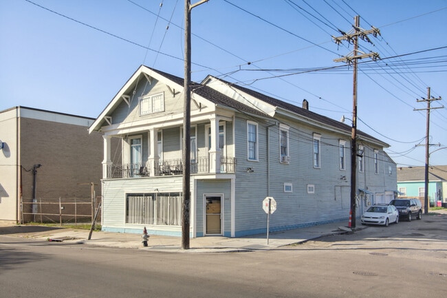
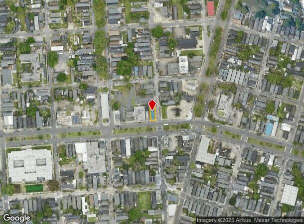
2433 Saint Claude Ave, New Orleans, LA 70117
This Property Is For Sale
NEARBY LISTINGS FOR SALE OR LEASE
Property Detail
2433 Saint Claude Ave
New Orleans-Metairie, LA
New Marigny 8Th Ward
3-8W-1-037-13
SQ 394 LOT 1 OR 14 ST CLAUDE AND MUSIC 33X105 TRIPLEX W/FR 2/STY 13/RM A/R & BUSIN ESS 2433-35 ST CLAUDE AVE OR 1104 MUSIC ST
Miscresidentialimprovement
Orleans
X
Louisiana
22051C0225F
14
2025
0.08 AC
2025
New Orleans CBD/French Quarter
001900
New Orleans/Metairie/Kenner
5,107 SF
DEMOGRAPHICS near 2433 Saint Claude Ave
1 Mile
3 Mile
5 Mile
2024 Total Population
23,081
136,766
331,329
2029 Population
22,669
133,256
320,343
Pop Growth 2024-2029
(1.79%)
(2.57%)
(3.32%)
Average Age
44
42
40
2024 Total Households
12,128
65,854
145,431
HH Growth 2024-2029
(1.83%)
(2.43%)
(3.35%)
Median Household Inc
$40,946
$40,452
$47,702
Avg Household Size
1.80
2.00
2.10
2024 Avg HH Vehicles
1.00
1.00
1.00
Median Home Value
$329,930
$268,694
$288,668
Median Year Built
1946
1949
1954
Nearby Places
- Restaurants
- Banks
- Shops
- Fitness
- Groceries
PUBLIC TRANSPORTATION
TRANSIT/SUBWAY
Esplanade Avenue Station (Canal-Cemeteries Streetcar - New Orleans Regional Transit Authority Streetcars (New Orleans Streetcars), Canal-Museum Streetcar - New Orleans Regional Transit Authority Streetcars (New Orleans Streetcars), Riverfront Streetcar - New Orleans Regional Transit Authority Streetcars (New Orleans Streetcars))
DRIVE
WALK
Distance
Esplanade Avenue Station (Canal-Cemeteries Streetcar - New Orleans Regional Transit Authority Streetcars (New Orleans Streetcars), Canal-Museum Streetcar - New Orleans Regional Transit Authority Streetcars (New Orleans Streetcars), Riverfront Streetcar - New Orleans Regional Transit Authority Streetcars (New Orleans Streetcars))
5 min
16 min
0.8 mi
Ursulines Street Station (Canal-Cemeteries Streetcar - New Orleans Regional Transit Authority Streetcars (New Orleans Streetcars), Canal-Museum Streetcar - New Orleans Regional Transit Authority Streetcars (New Orleans Streetcars), Riverfront Streetcar - New Orleans Regional Transit Authority Streetcars (New Orleans Streetcars))
DRIVE
WALK
Distance
Ursulines Street Station (Canal-Cemeteries Streetcar - New Orleans Regional Transit Authority Streetcars (New Orleans Streetcars), Canal-Museum Streetcar - New Orleans Regional Transit Authority Streetcars (New Orleans Streetcars), Riverfront Streetcar - New Orleans Regional Transit Authority Streetcars (New Orleans Streetcars))
4 min
20 min
1.0 mi
COMMUTER RAIL
DRIVE
WALK
Distance
7 min
2.6 mi
AIRPORT
Louis Armstrong New Orleans International
DRIVE
WALK
Distance
Louis Armstrong New Orleans International
24 min
15.7 mi
Freight Ports
Port of New Orleans
DRIVE
WALK
Distance
Port of New Orleans
15 min
6.3 mi
Nearby Properties
Address
Land Use
TOTAL SIZE
Lot Size
Zoning
Address
Land Use
TOTAL SIZE
Lot Size
Zoning
Address
Land Use
TOTAL SIZE
Lot Size
Zoning
300 SF
2.19 AC
LS
Address
Land Use
TOTAL SIZE
Lot Size
Zoning
85,052 SF
2.19 AC
LS
Address
Land Use
TOTAL SIZE
Lot Size
Zoning
44.43 AC
CBD-4
Address
Land Use
TOTAL SIZE
Lot Size
Zoning
66.23 AC
CBD-4
Address
Land Use
TOTAL SIZE
Lot Size
Zoning
834,043 SF
1.40 AC
CBD-2
Address
Land Use
TOTAL SIZE
Lot Size
Zoning
18.31 AC
CBD-4
Address
Land Use
TOTAL SIZE
Lot Size
Zoning
1.87 AC
CBD-2
Address
Land Use
TOTAL SIZE
Lot Size
Zoning
6.64 AC
Address
Land Use
TOTAL SIZE
Lot Size
Zoning
844,362 SF
5.85 AC
CBD-4
Address
Land Use
TOTAL SIZE
Lot Size
Zoning
30.63 AC
Address
Land Use
TOTAL SIZE
Lot Size
Zoning
444,121 SF
1.46 AC
CBD-1
Address
Land Use
TOTAL SIZE
Lot Size
Zoning
0.88 AC
CBD-2
Address
Land Use
TOTAL SIZE
Lot Size
Zoning
22.17 AC
Address
Land Use
TOTAL SIZE
Lot Size
Zoning
1.91 AC
CBD-1
Address
Land Use
TOTAL SIZE
Lot Size
Zoning
576,962 SF
3.31 AC
CBD-4
Address
Land Use
TOTAL SIZE
Lot Size
Zoning
1.79 AC
Address
Land Use
TOTAL SIZE
Lot Size
Zoning
512,729 SF
6.60 AC
Address
Land Use
TOTAL SIZE
Lot Size
Zoning
1.24 AC
CBD-1
Address
Land Use
TOTAL SIZE
Lot Size
Zoning
190,708 SF
1.09 AC
CBD-2
Address
Land Use
TOTAL SIZE
Lot Size
Zoning
225,284 SF
16.83 AC
S-RD
Address
Land Use
TOTAL SIZE
Lot Size
Zoning
499,287 SF
1.44 AC
VCE
Address
Land Use
TOTAL SIZE
Lot Size
Zoning
0.67 AC
CBD-3
Address
Land Use
TOTAL SIZE
Lot Size
Zoning
202,291 SF
4.04 AC
HU-RD2
Address
Land Use
TOTAL SIZE
Lot Size
Zoning
162,382 SF
1.25 AC
CBD-2
Address
Land Use
TOTAL SIZE
Lot Size
Zoning
258,024 SF
0.63 AC
CBD-2
Address
Land Use
TOTAL SIZE
Lot Size
Zoning
2.94 AC
CBD-1
Address
Land Use
TOTAL SIZE
Lot Size
Zoning
462,672 SF
1.11 AC
CBD-1
Address
Land Use
TOTAL SIZE
Lot Size
Zoning
1.84 AC
CBD-7
Address
Land Use
TOTAL SIZE
Lot Size
Zoning
224,374 SF
92.67 AC
HU-RD1
The World's #1 Commercial Real Estate Marketplace
Connect with us
© 2025 CoStar Group
The information above has been obtained from sources believed reliable. While we do not doubt its accuracy we have not verified it and make no guarantee, warranty or representation about it. It is your responsibility to independently confirm its accuracy and completeness. Any projections, opinions, assumptions, or estimates used are for example only and do not represent the current or future performance of the property. The value of this transaction to you depends on tax and other factors which should be evaluated by your tax, financial, and legal advisors. You and your advisors should conduct a careful, independent investigation of the property to determine to your satisfaction the suitability of the property for your needs.