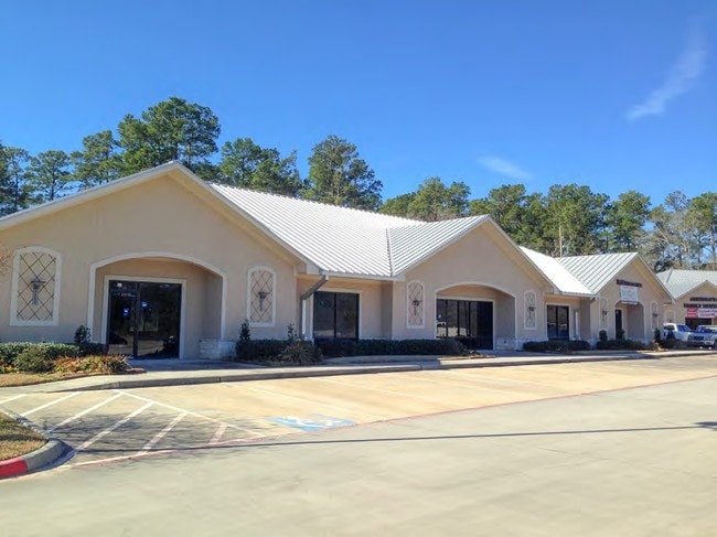
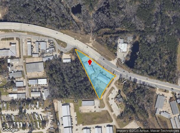
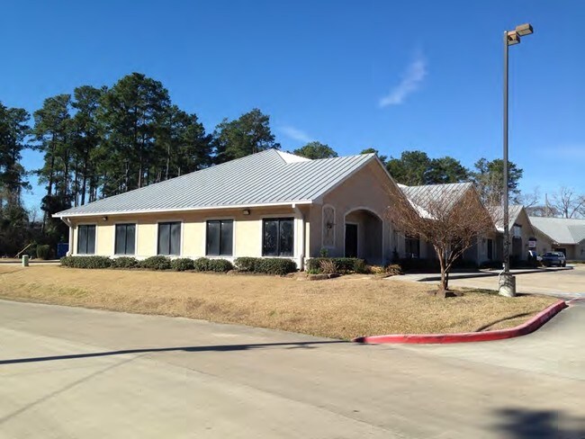
Property Record
1100 Rayford Rd, Spring, TX 77386
NEARBY LISTINGS FOR SALE OR LEASE
Property Detail
1100 Rayford Rd
Houston-Pasadena-The Woodlands, TX
Rayford Bend South
8249-00-00105
S824900 - RAYFORD BEND SOUTH, BLOCK 1, LOT RES A1-D, ACRES 2.0867
Commercialnec
Montgomery
X
Texas
48339C0545G
r
2024
2.09 AC
2025
The Woodlands
691900
Houston
18,864 SF
DEMOGRAPHICS near 1100 Rayford Rd
1 Mile
3 Mile
5 Mile
2024 Total Population
7,873
85,783
175,278
2029 Population
9,643
102,833
204,634
Pop Growth 2024-2029
+ 22.48%
+ 19.88%
+ 16.75%
Average Age
35
36
37
2024 Total Households
2,750
30,655
63,746
HH Growth 2024-2029
+ 22.58%
+ 20.04%
+ 17.16%
Median Household Inc
$82,311
$92,684
$98,250
Avg Household Size
2.80
2.80
2.70
2024 Avg HH Vehicles
2.00
2.00
2.00
Median Home Value
$227,119
$268,694
$276,179
Median Year Built
1996
2002
2004
Nearby Places
Map Layers
Map Styles
 Street
 Aerial
- Restaurants
- Banks
- Shops
- Fitness
- Groceries
PUBLIC TRANSPORTATION
AIRPORT
George Bush Intcntl/Houston
DRIVE
WALK
Distance
George Bush Intcntl/Houston
23 min
19.4 mi
Freight Ports
Port of Houston
DRIVE
WALK
Distance
Port of Houston
1 min
28.9 mi
SALE & LEASE HISTORY
LISTING DATE
SALE/LEASE

Feb 20, 2018
For Lease
Aug 29, 2017
For Lease
Nearby Properties
Address
Land Use
TOTAL SIZE
Lot Size
Zoning
Address
Land Use
TOTAL SIZE
Lot Size
Zoning
6,576,138 SF
186.74 AC
Address
Land Use
TOTAL SIZE
Lot Size
Zoning
1,673,574 SF
5.10 AC
Address
Land Use
TOTAL SIZE
Lot Size
Zoning
1,186,001 SF
13.27 AC
Address
Land Use
TOTAL SIZE
Lot Size
Zoning
1,004,830 SF
7.83 AC
Address
Land Use
TOTAL SIZE
Lot Size
Zoning
1,053,284 SF
2.25 AC
Address
Land Use
TOTAL SIZE
Lot Size
Zoning
974,064 SF
11.79 AC
Address
Land Use
TOTAL SIZE
Lot Size
Zoning
802,274 SF
2.68 AC
Address
Land Use
TOTAL SIZE
Lot Size
Zoning
178,645 SF
8.74 AC
Address
Land Use
TOTAL SIZE
Lot Size
Zoning
457,883 SF
3.74 AC
Address
Land Use
TOTAL SIZE
Lot Size
Zoning
368,000 SF
8.65 AC
Address
Land Use
TOTAL SIZE
Lot Size
Zoning
467,928 SF
6 AC
Address
Land Use
TOTAL SIZE
Lot Size
Zoning
296,094 SF
10.19 AC
Address
Land Use
TOTAL SIZE
Lot Size
Zoning
279,413 SF
12.45 AC
6
Address
Land Use
TOTAL SIZE
Lot Size
Zoning
532,751 SF
6.43 AC
Address
Land Use
TOTAL SIZE
Lot Size
Zoning
314,169 SF
3.09 AC
Address
Land Use
TOTAL SIZE
Lot Size
Zoning
246,719 SF
1.25 AC
Address
Land Use
TOTAL SIZE
Lot Size
Zoning
325,294 SF
21.81 AC
6
Address
Land Use
TOTAL SIZE
Lot Size
Zoning
388,855 SF
19.86 AC
6
Address
Land Use
TOTAL SIZE
Lot Size
Zoning
454,330 SF
9.77 AC
Address
Land Use
TOTAL SIZE
Lot Size
Zoning
373,310 SF
2.47 AC
Address
Land Use
TOTAL SIZE
Lot Size
Zoning
327,690 SF
14.50 AC
Address
Land Use
TOTAL SIZE
Lot Size
Zoning
141,454 SF
21.13 AC
Address
Land Use
TOTAL SIZE
Lot Size
Zoning
471,015 SF
6.63 AC
Address
Land Use
TOTAL SIZE
Lot Size
Zoning
397,984 SF
6.42 AC
Address
Land Use
TOTAL SIZE
Lot Size
Zoning
333,146 SF
14.81 AC
6
Address
Land Use
TOTAL SIZE
Lot Size
Zoning
343,521 SF
9.88 AC
Address
Land Use
TOTAL SIZE
Lot Size
Zoning
293,997 SF
12.87 AC
6
Address
Land Use
TOTAL SIZE
Lot Size
Zoning
278,533 SF
14.79 AC
6
Address
Land Use
TOTAL SIZE
Lot Size
Zoning
225,861 SF
0.86 AC
Address
Land Use
TOTAL SIZE
Lot Size
Zoning
331,264 SF
12.92 AC
The World's #1 Commercial Real Estate Marketplace
Connect with us
© 2026 CoStar Group
The information above has been obtained from sources believed reliable. While we do not doubt its accuracy we have not verified it and make no guarantee, warranty or representation about it. It is your responsibility to independently confirm its accuracy and completeness. Any projections, opinions, assumptions, or estimates used are for example only and do not represent the current or future performance of the property. The value of this transaction to you depends on tax and other factors which should be evaluated by your tax, financial, and legal advisors. You and your advisors should conduct a careful, independent investigation of the property to determine to your satisfaction the suitability of the property for your needs.