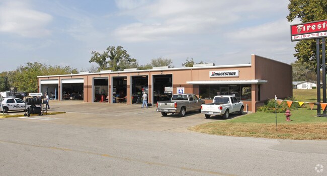
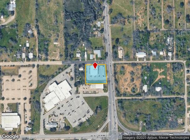
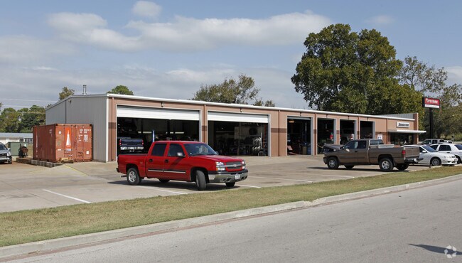
Property Record
1104 State Highway 95 St, Bastrop, TX 78602
NEARBY LISTINGS FOR SALE OR LEASE
Property Detail
1104 State Highway 95 St
Austin-Round Rock-San Marcos, TX
Chestnut Square
45672
CHESTNUT SQUARE, LOT 1, ACRES 1.0736
Commercialnec
Bastrop
AE
Texas
48021C0360F
1
2024
1.07 AC
2025
Bastrop County
950401
Austin
8,496 SF
DEMOGRAPHICS near 1104 State Highway 95 St
1 mile
3 mile
5 mile
2024 Total Population
2,712
17,962
29,491
2029 Population
3,375
22,479
36,776
Pop Growth 2024-2029
+ 24.45%
+ 25.15%
+ 24.70%
Average Age
43
40
40
2024 Total Households
1,130
7,013
10,658
HH Growth 2024-2029
+ 25.49%
+ 26.21%
+ 26.00%
Median Household Inc
$75,100
$86,995
$90,102
Avg Household Size
2.30
2.50
2.60
2024 Avg HH Vehicles
2.00
2.00
2.00
Median Home Value
$247,941
$241,433
$242,251
Median Year Built
1986
2001
2002
Nearby Places
Map Layers
Map Styles
 Street
 Aerial
Transit
 Traffic
 Biking
Places
Listings with unknown addresses are not visible on the map
- Restaurants
- Banks
- Shops
- Fitness
- Groceries
PUBLIC TRANSPORTATION
AIRPORT
Austin-Bergstrom International
Drive
Walk
Distance
Austin-Bergstrom International
40 min
27.4 mi
Nearby Properties
Address
Land Use
TOTAL SIZE
Lot Size
Zoning
Address
Land Use
TOTAL SIZE
Lot Size
Zoning
120,000 SF
12.54 AC
Address
Land Use
TOTAL SIZE
Lot Size
Zoning
38,112 SF
24.16 AC
Address
Land Use
TOTAL SIZE
Lot Size
Zoning
25.59 AC
Address
Land Use
TOTAL SIZE
Lot Size
Zoning
140,496 SF
8.05 AC
Address
Land Use
TOTAL SIZE
Lot Size
Zoning
140,878 SF
8.31 AC
Address
Land Use
TOTAL SIZE
Lot Size
Zoning
123,176 SF
29.42 AC
Address
Land Use
TOTAL SIZE
Lot Size
Zoning
83,994 SF
7.83 AC
Address
Land Use
TOTAL SIZE
Lot Size
Zoning
180,568 SF
23.98 AC
Address
Land Use
TOTAL SIZE
Lot Size
Zoning
105,020 SF
13.43 AC
Address
Land Use
TOTAL SIZE
Lot Size
Zoning
125,000 SF
11.98 AC
Address
Land Use
TOTAL SIZE
Lot Size
Zoning
65,206 SF
2.55 AC
Address
Land Use
TOTAL SIZE
Lot Size
Zoning
49,508 SF
6.58 AC
Address
Land Use
TOTAL SIZE
Lot Size
Zoning
169,350 SF
25.30 AC
Address
Land Use
TOTAL SIZE
Lot Size
Zoning
121,305 SF
16.06 AC
Address
Land Use
TOTAL SIZE
Lot Size
Zoning
24,788 SF
Address
Land Use
TOTAL SIZE
Lot Size
Zoning
59,941 SF
4.57 AC
Address
Land Use
TOTAL SIZE
Lot Size
Zoning
40,261 SF
15 AC
Address
Land Use
TOTAL SIZE
Lot Size
Zoning
173,350 SF
10.58 AC
Address
Land Use
TOTAL SIZE
Lot Size
Zoning
Address
Land Use
TOTAL SIZE
Lot Size
Zoning
133,292 SF
2.67 AC
Address
Land Use
TOTAL SIZE
Lot Size
Zoning
69,508 SF
4.10 AC
Address
Land Use
TOTAL SIZE
Lot Size
Zoning
125,948 SF
12.76 AC
Address
Land Use
TOTAL SIZE
Lot Size
Zoning
54,856 SF
4.15 AC
Address
Land Use
TOTAL SIZE
Lot Size
Zoning
67,979 SF
4.08 AC
Address
Land Use
TOTAL SIZE
Lot Size
Zoning
47,126 SF
3.33 AC
Address
Land Use
TOTAL SIZE
Lot Size
Zoning
32,828 SF
4.02 AC
Address
Land Use
TOTAL SIZE
Lot Size
Zoning
62,734 SF
2.55 AC
Address
Land Use
TOTAL SIZE
Lot Size
Zoning
27,936 SF
5 AC
Address
Land Use
TOTAL SIZE
Lot Size
Zoning
97,631 SF
14.03 AC
Address
Land Use
TOTAL SIZE
Lot Size
Zoning
53,318 SF
5.36 AC
The World's #1 Commercial Real Estate Marketplace
Connect with us
© 2026 CoStar Group
The information above has been obtained from sources believed reliable. While we do not doubt its accuracy we have not verified it and make no guarantee, warranty or representation about it. It is your responsibility to independently confirm its accuracy and completeness. Any projections, opinions, assumptions, or estimates used are for example only and do not represent the current or future performance of the property. The value of this transaction to you depends on tax and other factors which should be evaluated by your tax, financial, and legal advisors. You and your advisors should conduct a careful, independent investigation of the property to determine to your satisfaction the suitability of the property for your needs.