Property Record
11048 Sw County Road 769, Arcadia, FL 34269


NEARBY LISTINGS FOR SALE OR LEASE
Property Detail
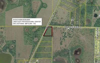
11048 Sw County Road 769
29-39-23-0000-0030-0000
BEG NE COR TH S 00D12M07S W 32.67 FT TO POB TH CONT SAME LI 563 FT TH N 89D37M04S W 524.67 FT TO E R/W CR 741 TH N 26D12M26S E ALG R/W 598.04 FT TH N 72D13M32S E 88.51 FT TH S 88D30M41S E 178.03 FT TO POB INST:201414002321
Pasture
DeSoto
X
Florida
12015C0070G
5 AC
2024
Florida Central South Area
2024
Other Market Areas
010405
Arcadia, FL
DEMOGRAPHICS near 11048 Sw County Road 769
1 Mile
3 Mile
5 Mile
2024 Total Population
569
9,117
37,781
2029 Population
634
10,615
44,713
Pop Growth 2024-2029
+ 11.42%
+ 16.43%
+ 18.35%
Average Age
49
54
52
2024 Total Households
237
4,185
16,896
HH Growth 2024-2029
+ 12.24%
+ 16.73%
+ 18.77%
Median Household Inc
$63,600
$57,900
$61,668
Avg Household Size
2.40
2.20
2.20
2024 Avg HH Vehicles
2.00
2.00
2.00
Median Home Value
$196,225
$259,815
$239,617
Median Year Built
1988
1994
1994
Nearby Places
Map Layers
Map Styles
 Street
 Aerial
- Restaurants
- Banks
- Shops
- Fitness
- Groceries
PUBLIC TRANSPORTATION
AIRPORT
Punta Gorda
DRIVE
WALK
Distance
Punta Gorda
20 min
12.9 mi
Freight Ports
Port Manatee
DRIVE
WALK
Distance
Port Manatee
81 min
67.3 mi
Nearby Properties
Address
Land Use
TOTAL SIZE
Lot Size
Zoning
Address
Land Use
TOTAL SIZE
Lot Size
Zoning
653.75 AC
A-10
Address
Land Use
TOTAL SIZE
Lot Size
Zoning
217,784 SF
38.63 AC
PD
Address
Land Use
TOTAL SIZE
Lot Size
Zoning
41,148 SF
155.85 AC
RSF-3
Address
Land Use
TOTAL SIZE
Lot Size
Zoning
173.33 AC
P/I
Address
Land Use
TOTAL SIZE
Lot Size
Zoning
594.36 AC
A-10
Address
Land Use
TOTAL SIZE
Lot Size
Zoning
82.27 AC
PD
Address
Land Use
TOTAL SIZE
Lot Size
Zoning
153.66 AC
P/I
Address
Land Use
TOTAL SIZE
Lot Size
Zoning
11,773 SF
1.55 AC
PD
Address
Land Use
TOTAL SIZE
Lot Size
Zoning
1,836 SF
17.80 AC
P/I
Address
Land Use
TOTAL SIZE
Lot Size
Zoning
8,044 SF
29.55 AC
TTRVC
Address
Land Use
TOTAL SIZE
Lot Size
Zoning
23,566 SF
20.33 AC
RMF10
Address
Land Use
TOTAL SIZE
Lot Size
Zoning
662.52 AC
EC
Address
Land Use
TOTAL SIZE
Lot Size
Zoning
9,908 SF
40 AC
RVC
Address
Land Use
TOTAL SIZE
Lot Size
Zoning
24,509 SF
3.72 AC
PD
Address
Land Use
TOTAL SIZE
Lot Size
Zoning
172.19 AC
PUD
Address
Land Use
TOTAL SIZE
Lot Size
Zoning
509 AC
A-5
Address
Land Use
TOTAL SIZE
Lot Size
Zoning
55,310 SF
3.20 AC
CG
Address
Land Use
TOTAL SIZE
Lot Size
Zoning
651.43 AC
A-10
Address
Land Use
TOTAL SIZE
Lot Size
Zoning
3,248 SF
21.20 AC
MHP
Address
Land Use
TOTAL SIZE
Lot Size
Zoning
649.60 AC
A-10
Address
Land Use
TOTAL SIZE
Lot Size
Zoning
623.08 AC
A-10
Address
Land Use
TOTAL SIZE
Lot Size
Zoning
37.68 AC
PD
Address
Land Use
TOTAL SIZE
Lot Size
Zoning
23.31 AC
CG
Address
Land Use
TOTAL SIZE
Lot Size
Zoning
7,992 SF
1.20 AC
PD
Address
Land Use
TOTAL SIZE
Lot Size
Zoning
13,552 SF
1.83 AC
PD
Address
Land Use
TOTAL SIZE
Lot Size
Zoning
4,979 SF
2.33 AC
PD
Address
Land Use
TOTAL SIZE
Lot Size
Zoning
14,863 SF
12.50 AC
PD
Address
Land Use
TOTAL SIZE
Lot Size
Zoning
30,720 SF
2.89 AC
CG
Address
Land Use
TOTAL SIZE
Lot Size
Zoning
31.61 AC
RVC
Address
Land Use
TOTAL SIZE
Lot Size
Zoning
7,913 SF
1.15 AC
PD
The World's #1 Commercial Real Estate Marketplace
Connect with us
© 2025 CoStar Group
The information above has been obtained from sources believed reliable. While we do not doubt its accuracy we have not verified it and make no guarantee, warranty or representation about it. It is your responsibility to independently confirm its accuracy and completeness. Any projections, opinions, assumptions, or estimates used are for example only and do not represent the current or future performance of the property. The value of this transaction to you depends on tax and other factors which should be evaluated by your tax, financial, and legal advisors. You and your advisors should conduct a careful, independent investigation of the property to determine to your satisfaction the suitability of the property for your needs.