Property Record
1105 E Bismarck Expy, Bismarck, ND 58504
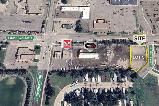

Property Detail
1105 E Bismarck Expy
1041-001-050
JACKS FIRST ADDITION LOT 3
Autorepair
BURLEIGH
MA
North Dakota
AE The base floodplain where base flood elevations are provided. AE Zones are now used on new format FIRMs instead of A1-A30 Zones.
3
2025
0.54 AC
2025
Cottonwood
011300
Other Market Areas
1,359 SF
Bismarck, ND
NEARBY LISTINGS FOR SALE OR LEASE
-
-
View all Bismarck listings for sale on LoopNet.com
DEMOGRAPHICS near 1105 E Bismarck Expy
1 mile
3 mile
5 mile
2025 Total Population
9,531
53,518
94,319
2030 Population
9,837
55,113
97,306
Pop Growth 2025-2030
+ 3.21%
+ 2.98%
+ 3.17%
Average Age
41
40
40
2025 Total Households
4,516
23,836
39,346
HH Growth 2025-2030
+ 3.79%
+ 3.34%
+ 3.47%
Median Household Inc
$55,034
$71,658
$84,006
Avg Household Size
2.00
2.10
2.20
2025 Avg HH Vehicles
2.00
2.00
2.00
Median Home Value
$203,077
$266,365
$297,106
Median Year Built
1975
1976
1988
Nearby Places
Map Layers
Map Styles
 Street
 Aerial
Layers
 Traffic
 Biking
Places
Listings with unknown addresses are not visible on the map
- Restaurants
- Banks
- Shops
- Fitness
- Groceries
PUBLIC TRANSPORTATION
AIRPORT
Bismarck Municipal
Drive
Walk
Distance
Bismarck Municipal
13 min
3.3 mi
SALE & LEASE HISTORY
LISTING DATE
SALE/LEASE

Oct 27, 2023
For Sale
Nearby Properties
Address
Land Use
TOTAL SIZE
Lot Size
Zoning
Address
Land Use
TOTAL SIZE
Lot Size
Zoning
45.23 AC
CG
Address
Land Use
TOTAL SIZE
Lot Size
Zoning
26.42 AC
MA
Address
Land Use
TOTAL SIZE
Lot Size
Zoning
93,860 SF
1.44 AC
HM
Address
Land Use
TOTAL SIZE
Lot Size
Zoning
30.33 AC
MA
Address
Land Use
TOTAL SIZE
Lot Size
Zoning
35.42 AC
MA
Address
Land Use
TOTAL SIZE
Lot Size
Zoning
70,182 SF
3.83 AC
PUD
Address
Land Use
TOTAL SIZE
Lot Size
Zoning
60,105 SF
11.86 AC
RM30
Address
Land Use
TOTAL SIZE
Lot Size
Zoning
6.29 AC
RM30
Address
Land Use
TOTAL SIZE
Lot Size
Zoning
20.41 AC
MA
Address
Land Use
TOTAL SIZE
Lot Size
Zoning
44,652 SF
13.84 AC
RM30
Address
Land Use
TOTAL SIZE
Lot Size
Zoning
81,092 SF
4.17 AC
HM
Address
Land Use
TOTAL SIZE
Lot Size
Zoning
38,467 SF
13.89 AC
CG
Address
Land Use
TOTAL SIZE
Lot Size
Zoning
11.48 AC
CG
Address
Land Use
TOTAL SIZE
Lot Size
Zoning
10.84 AC
CG
Address
Land Use
TOTAL SIZE
Lot Size
Zoning
14.70 AC
MA
Address
Land Use
TOTAL SIZE
Lot Size
Zoning
14.22 AC
MA
Address
Land Use
TOTAL SIZE
Lot Size
Zoning
62,652 SF
2.34 AC
HM
Address
Land Use
TOTAL SIZE
Lot Size
Zoning
10.14 AC
CG
Address
Land Use
TOTAL SIZE
Lot Size
Zoning
25.59 AC
CG
Address
Land Use
TOTAL SIZE
Lot Size
Zoning
81.73 AC
RMH
Address
Land Use
TOTAL SIZE
Lot Size
Zoning
30,852 SF
2.04 AC
CG
Address
Land Use
TOTAL SIZE
Lot Size
Zoning
10.58 AC
CG
Address
Land Use
TOTAL SIZE
Lot Size
Zoning
15,656 SF
8.98 AC
RM30
Address
Land Use
TOTAL SIZE
Lot Size
Zoning
42,908 SF
12.44 AC
MA
Address
Land Use
TOTAL SIZE
Lot Size
Zoning
42,908 SF
12.14 AC
MA
Address
Land Use
TOTAL SIZE
Lot Size
Zoning
7,288 SF
7.50 AC
CG
Address
Land Use
TOTAL SIZE
Lot Size
Zoning
98,908 SF
2.33 AC
MA
Address
Land Use
TOTAL SIZE
Lot Size
Zoning
14.65 AC
CG
Address
Land Use
TOTAL SIZE
Lot Size
Zoning
48,661 SF
4.91 AC
CG
Address
Land Use
TOTAL SIZE
Lot Size
Zoning
88,263 SF
8.58 AC
CG
The World's #1 Commercial Real Estate Marketplace
Connect with us
© 2026 CoStar Group
The information above has been obtained from sources believed reliable. While we do not doubt its accuracy we have not verified it and make no guarantee, warranty or representation about it. It is your responsibility to independently confirm its accuracy and completeness. Any projections, opinions, assumptions, or estimates used are for example only and do not represent the current or future performance of the property. The value of this transaction to you depends on tax and other factors which should be evaluated by your tax, financial, and legal advisors. You and your advisors should conduct a careful, independent investigation of the property to determine to your satisfaction the suitability of the property for your needs.