Property Record
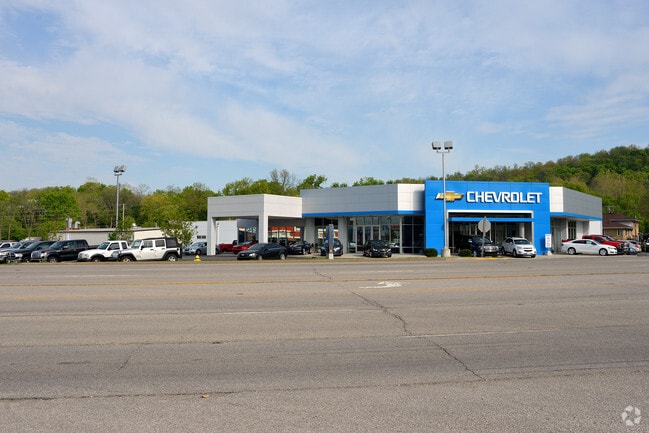
1105 E Eads Pky, Greendale, IN 47025


NEARBY LISTINGS FOR SALE OR LEASE
-
-
View all Greendale listings for sale on LoopNet.com
Property Detail
1105 E Eads Pky
15-07-02-301-021.000-016
Sw4s2t5nr1w
Vehiclerentalsvehiclesales
07-66 PT SW 2-5-1 2.60A
X
Dearborn
18115C0050C
Indiana
2024
2.60 AC
2024
Dearborn County
080302
Cincinnati/Dayton
6,476 SF
Cincinnati, OH-KY-IN
DEMOGRAPHICS near 1105 E Eads Pky
1 Mile
3 Mile
5 Mile
2024 Total Population
2,360
13,277
23,179
2029 Population
2,424
13,763
23,908
Pop Growth 2024-2029
+ 2.71%
+ 3.66%
+ 3.15%
Average Age
41
41
41
2024 Total Households
956
5,335
9,037
HH Growth 2024-2029
+ 2.62%
+ 3.73%
+ 3.16%
Median Household Inc
$77,352
$65,759
$74,349
Avg Household Size
2.40
2.40
2.50
2024 Avg HH Vehicles
2.00
2.00
2.00
Median Home Value
$170,901
$173,485
$187,608
Median Year Built
1972
1978
1980
Nearby Places
Map Layers
Map Styles
 Street
 Aerial
- Restaurants
- Banks
- Shops
- Fitness
- Groceries
PUBLIC TRANSPORTATION
AIRPORT
Cincinnati/Northern Kentucky International
DRIVE
WALK
Distance
Cincinnati/Northern Kentucky International
29 min
16.9 mi
Freight Ports
Port of Toledo
DRIVE
WALK
Distance
Port of Toledo
255 min
218.9 mi
Nearby Properties
Address
Land Use
TOTAL SIZE
Lot Size
Zoning
Address
Land Use
TOTAL SIZE
Lot Size
Zoning
491,407 SF
10.84 AC
Address
Land Use
TOTAL SIZE
Lot Size
Zoning
1,712 SF
Address
Land Use
TOTAL SIZE
Lot Size
Zoning
255,203 SF
3.04 AC
Address
Land Use
TOTAL SIZE
Lot Size
Zoning
2.08 AC
Address
Land Use
TOTAL SIZE
Lot Size
Zoning
2.10 AC
G
Address
Land Use
TOTAL SIZE
Lot Size
Zoning
12,000 SF
61.29 AC
Address
Land Use
TOTAL SIZE
Lot Size
Zoning
3.30 AC
Address
Land Use
TOTAL SIZE
Lot Size
Zoning
60,868 SF
8.90 AC
Address
Land Use
TOTAL SIZE
Lot Size
Zoning
43,895 SF
59.12 AC
Address
Land Use
TOTAL SIZE
Lot Size
Zoning
18,114 SF
18.96 AC
Address
Land Use
TOTAL SIZE
Lot Size
Zoning
64,875 SF
3.10 AC
Address
Land Use
TOTAL SIZE
Lot Size
Zoning
1,868 SF
441.70 AC
Address
Land Use
TOTAL SIZE
Lot Size
Zoning
24,487 SF
8.81 AC
Address
Land Use
TOTAL SIZE
Lot Size
Zoning
63,980 SF
10.50 AC
Address
Land Use
TOTAL SIZE
Lot Size
Zoning
94,974 SF
8.06 AC
Address
Land Use
TOTAL SIZE
Lot Size
Zoning
35,018 SF
4 AC
Address
Land Use
TOTAL SIZE
Lot Size
Zoning
32,169 SF
5.49 AC
Address
Land Use
TOTAL SIZE
Lot Size
Zoning
19,377 SF
6 AC
Address
Land Use
TOTAL SIZE
Lot Size
Zoning
43,920 SF
11.46 AC
Address
Land Use
TOTAL SIZE
Lot Size
Zoning
69,075 SF
3.10 AC
Address
Land Use
TOTAL SIZE
Lot Size
Zoning
200 SF
49.08 AC
Address
Land Use
TOTAL SIZE
Lot Size
Zoning
38,658 SF
5.38 AC
Address
Land Use
TOTAL SIZE
Lot Size
Zoning
222,717 SF
9.94 AC
Address
Land Use
TOTAL SIZE
Lot Size
Zoning
40,872 SF
1.31 AC
Address
Land Use
TOTAL SIZE
Lot Size
Zoning
210,672 SF
8.15 AC
Address
Land Use
TOTAL SIZE
Lot Size
Zoning
37,296 SF
2.02 AC
Address
Land Use
TOTAL SIZE
Lot Size
Zoning
40,400 SF
10.74 AC
Address
Land Use
TOTAL SIZE
Lot Size
Zoning
7,236 SF
6.97 AC
Address
Land Use
TOTAL SIZE
Lot Size
Zoning
13,136 SF
2.42 AC
Address
Land Use
TOTAL SIZE
Lot Size
Zoning
197,238 SF
5.83 AC
The World's #1 Commercial Real Estate Marketplace
Connect with us
© 2025 CoStar Group
The information above has been obtained from sources believed reliable. While we do not doubt its accuracy we have not verified it and make no guarantee, warranty or representation about it. It is your responsibility to independently confirm its accuracy and completeness. Any projections, opinions, assumptions, or estimates used are for example only and do not represent the current or future performance of the property. The value of this transaction to you depends on tax and other factors which should be evaluated by your tax, financial, and legal advisors. You and your advisors should conduct a careful, independent investigation of the property to determine to your satisfaction the suitability of the property for your needs.