Property Record
1105 Lillyhill Dr, Needles, CA 92363
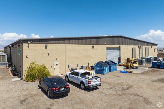

Property Detail
1105 Lillyhill Dr
0186-191-57
THAT PORTION OF THE SOUTH ONE-HALF OF THE NORTHWEST QUARTER OF SECTION 32, TOWNSHIP 9 NORTH, RANGE 23 EAST EXCEPT PORTION DESCRIBED AS FOLLOWS: PARCEL 2 OF PARCEL MAP 5762, TOGETHER WITH THAT PORTION OF PARCEL 1 OF SAID PARCEL MAP 5762 DESCRIBED AS F
Lightindustrial
San Bernardino
B and X Area of moderate flood hazard, usually the area between the limits of the 100-year and 500-year floods.
California
2025
14.89 AC
2025
San Bernardino Outlying
010700
Inland Empire (California)
30,375 SF
Riverside-San Bernardino-Ontario, CA
NEARBY LISTINGS FOR SALE OR LEASE
-
-
View all Needles listings for sale on LoopNet.com
DEMOGRAPHICS near 1105 Lillyhill Dr
1 mile
3 mile
5 mile
2025 Total Population
3,537
9,371
11,927
2030 Population
3,734
9,994
12,743
Pop Growth 2025-2030
+ 5.57%
+ 6.65%
+ 6.84%
Average Age
42
43
44
2025 Total Households
1,462
3,781
4,796
HH Growth 2025-2030
+ 5.61%
+ 6.59%
+ 6.82%
Median Household Inc
$41,341
$51,569
$56,101
Avg Household Size
2.40
2.50
2.50
2025 Avg HH Vehicles
2.00
2.00
2.00
Median Home Value
$154,150
$181,414
$196,199
Median Year Built
1979
1987
1987
Nearby Places
Map Layers
Map Styles
 Street
 Aerial
Layers
 Traffic
 Biking
Places
Listings with unknown addresses are not visible on the map
- Restaurants
- Banks
- Shops
- Fitness
- Groceries
PUBLIC TRANSPORTATION
COMMUTER RAIL
Needles Amtrak (Southwest Chief - Amtrak)
Drive
Walk
Distance
Needles Amtrak (Southwest Chief - Amtrak)
3 min
18 min
1.0 mi
AIRPORT
Laughlin/Bullhead International
Drive
Walk
Distance
Laughlin/Bullhead International
47 min
28.3 mi
Freight Ports
Port of San Diego
Drive
Walk
Distance
Port of San Diego
356 min
322.5 mi
Nearby Properties
Address
Land Use
TOTAL SIZE
Lot Size
Zoning
Address
Land Use
TOTAL SIZE
Lot Size
Zoning
46,499 SF
1.56 AC
Address
Land Use
TOTAL SIZE
Lot Size
Zoning
42,840 SF
2.57 AC
Address
Land Use
TOTAL SIZE
Lot Size
Zoning
80,000 SF
4.53 AC
Address
Land Use
TOTAL SIZE
Lot Size
Zoning
46,400 SF
1.60 AC
Address
Land Use
TOTAL SIZE
Lot Size
Zoning
164,720 SF
7.52 AC
Address
Land Use
TOTAL SIZE
Lot Size
Zoning
107,025 SF
9.28 AC
Address
Land Use
TOTAL SIZE
Lot Size
Zoning
46,500 SF
2.17 AC
Address
Land Use
TOTAL SIZE
Lot Size
Zoning
90,750 SF
6.07 AC
Address
Land Use
TOTAL SIZE
Lot Size
Zoning
29,181 SF
1.42 AC
Address
Land Use
TOTAL SIZE
Lot Size
Zoning
31,450 SF
2.50 AC
Address
Land Use
TOTAL SIZE
Lot Size
Zoning
20,000 SF
1.87 AC
Address
Land Use
TOTAL SIZE
Lot Size
Zoning
54,291 SF
6.96 AC
Address
Land Use
TOTAL SIZE
Lot Size
Zoning
61,750 SF
2.07 AC
Address
Land Use
TOTAL SIZE
Lot Size
Zoning
24,726 SF
2.15 AC
Address
Land Use
TOTAL SIZE
Lot Size
Zoning
51,234 SF
3.40 AC
Address
Land Use
TOTAL SIZE
Lot Size
Zoning
138,537 SF
6.30 AC
Address
Land Use
TOTAL SIZE
Lot Size
Zoning
4,941 SF
0.52 AC
Address
Land Use
TOTAL SIZE
Lot Size
Zoning
12,400 SF
0.21 AC
Address
Land Use
TOTAL SIZE
Lot Size
Zoning
73,344 SF
6.45 AC
Address
Land Use
TOTAL SIZE
Lot Size
Zoning
40,136 SF
4.52 AC
Address
Land Use
TOTAL SIZE
Lot Size
Zoning
69,900 SF
5.89 AC
Address
Land Use
TOTAL SIZE
Lot Size
Zoning
12,500 SF
0.80 AC
Address
Land Use
TOTAL SIZE
Lot Size
Zoning
9,100 SF
2.14 AC
Address
Land Use
TOTAL SIZE
Lot Size
Zoning
308,000 SF
Address
Land Use
TOTAL SIZE
Lot Size
Zoning
48,384 SF
2.46 AC
Address
Land Use
TOTAL SIZE
Lot Size
Zoning
7,263 SF
1.03 AC
The World's #1 Commercial Real Estate Marketplace
Connect with us
© 2026 CoStar Group
The information above has been obtained from sources believed reliable. While we do not doubt its accuracy we have not verified it and make no guarantee, warranty or representation about it. It is your responsibility to independently confirm its accuracy and completeness. Any projections, opinions, assumptions, or estimates used are for example only and do not represent the current or future performance of the property. The value of this transaction to you depends on tax and other factors which should be evaluated by your tax, financial, and legal advisors. You and your advisors should conduct a careful, independent investigation of the property to determine to your satisfaction the suitability of the property for your needs.