Property Record
1105 Mohawk Trl, Shelburne Falls, MA 01370
NEARBY LISTINGS FOR SALE OR LEASE
-
-
View all Shelburne Falls listings for sale on LoopNet.com
Property Detail
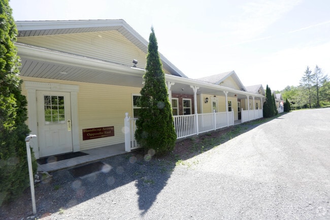
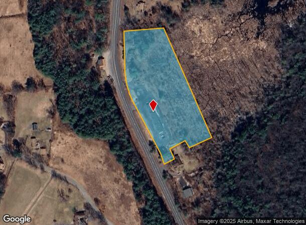
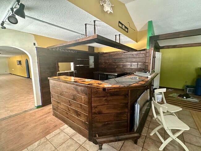
1105 Mohawk Trl
Greenfield Town, MA
William San Miguel
SHEL-000023D-000033
Franklin
Regionalshoppingcenterormallwithanchorstore
Massachusetts
2025
5.36 AC
2025
Franklin County
041502
Hartford
5,888 SF
DEMOGRAPHICS near 1105 Mohawk Trl
1 Mile
3 Mile
5 Mile
2024 Total Population
269
2,716
21,296
2029 Population
266
2,701
21,202
Pop Growth 2024-2029
(1.12%)
(0.55%)
(0.44%)
Average Age
50
47
45
2024 Total Households
113
1,105
9,820
HH Growth 2024-2029
(0.88%)
(0.27%)
(0.38%)
Median Household Inc
$87,500
$70,792
$59,848
Avg Household Size
2.30
2.20
2.00
2024 Avg HH Vehicles
2.00
2.00
2.00
Median Home Value
$353,488
$290,083
$260,312
Median Year Built
1973
1971
1949
Nearby Places
Map Layers
Map Styles
 Street
 Aerial
- Restaurants
- Banks
- Shops
- Fitness
- Groceries
PUBLIC TRANSPORTATION
COMMUTER RAIL
Greenfield Amtrak Station (Valley Flyer - Amtrak, Vermonter - Amtrak)
DRIVE
WALK
Distance
Greenfield Amtrak Station (Valley Flyer - Amtrak, Vermonter - Amtrak)
9 min
5.5 mi
Freight Ports
Albany, NY Port
DRIVE
WALK
Distance
Albany, NY Port
139 min
86.4 mi
SALE & LEASE HISTORY
LISTING DATE
SALE/LEASE

Nov 30, 2018
For Sale
Nov 30, 2018
For Lease
Nearby Properties
Address
Land Use
TOTAL SIZE
Lot Size
Zoning
Address
Land Use
TOTAL SIZE
Lot Size
Zoning
316,508 SF
80.01 AC
RB
Address
Land Use
TOTAL SIZE
Lot Size
Zoning
97,926 SF
8.65 AC
GC
Address
Land Use
TOTAL SIZE
Lot Size
Zoning
109 AC
C
Address
Land Use
TOTAL SIZE
Lot Size
Zoning
107,028 SF
14.46 AC
GC
Address
Land Use
TOTAL SIZE
Lot Size
Zoning
3,430 SF
10.70 AC
PN
Address
Land Use
TOTAL SIZE
Lot Size
Zoning
1,920 SF
9.11 AC
R1
Address
Land Use
TOTAL SIZE
Lot Size
Zoning
40,606 SF
1.48 AC
GC
Address
Land Use
TOTAL SIZE
Lot Size
Zoning
69,024 SF
6.28 AC
GC
Address
Land Use
TOTAL SIZE
Lot Size
Zoning
75,368 SF
22.23 AC
RA
Address
Land Use
TOTAL SIZE
Lot Size
Zoning
47,958 SF
7.74 AC
RB
Address
Land Use
TOTAL SIZE
Lot Size
Zoning
72,488 SF
5.13 AC
GC
Address
Land Use
TOTAL SIZE
Lot Size
Zoning
9,655 SF
30.65 AC
R
Address
Land Use
TOTAL SIZE
Lot Size
Zoning
21,825 SF
1.23 AC
GC
Address
Land Use
TOTAL SIZE
Lot Size
Zoning
4,358 SF
1.45 AC
GC
Address
Land Use
TOTAL SIZE
Lot Size
Zoning
5,700 SF
1.01 AC
GC
Address
Land Use
TOTAL SIZE
Lot Size
Zoning
35,640 SF
4.60 AC
GC
Address
Land Use
TOTAL SIZE
Lot Size
Zoning
4,328 SF
0.85 AC
GC
Address
Land Use
TOTAL SIZE
Lot Size
Zoning
4,150 SF
1.33 AC
GC
Address
Land Use
TOTAL SIZE
Lot Size
Zoning
14,016 SF
5.54 AC
RC
Address
Land Use
TOTAL SIZE
Lot Size
Zoning
9,300 SF
3.83 AC
GC
Address
Land Use
TOTAL SIZE
Lot Size
Zoning
10,944 SF
2.05 AC
RC
Address
Land Use
TOTAL SIZE
Lot Size
Zoning
34,900 SF
5 AC
GC
Address
Land Use
TOTAL SIZE
Lot Size
Zoning
7.41 AC
C
Address
Land Use
TOTAL SIZE
Lot Size
Zoning
2,880 SF
0.94 AC
GC
Address
Land Use
TOTAL SIZE
Lot Size
Zoning
364 AC
O
Address
Land Use
TOTAL SIZE
Lot Size
Zoning
2,100 SF
0.58 AC
GC
Address
Land Use
TOTAL SIZE
Lot Size
Zoning
0.23 AC
R1
Address
Land Use
TOTAL SIZE
Lot Size
Zoning
289 AC
O
Address
Land Use
TOTAL SIZE
Lot Size
Zoning
8,028 SF
38 AC
C
Address
Land Use
TOTAL SIZE
Lot Size
Zoning
1,024 SF
0.62 AC
GC
The World's #1 Commercial Real Estate Marketplace
Connect with us
© 2026 CoStar Group
The information above has been obtained from sources believed reliable. While we do not doubt its accuracy we have not verified it and make no guarantee, warranty or representation about it. It is your responsibility to independently confirm its accuracy and completeness. Any projections, opinions, assumptions, or estimates used are for example only and do not represent the current or future performance of the property. The value of this transaction to you depends on tax and other factors which should be evaluated by your tax, financial, and legal advisors. You and your advisors should conduct a careful, independent investigation of the property to determine to your satisfaction the suitability of the property for your needs.