Property Record
1105 N Highway 293 St Se, Cartersville, GA 30121
NEARBY LISTINGS FOR SALE OR LEASE
Property Detail
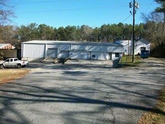
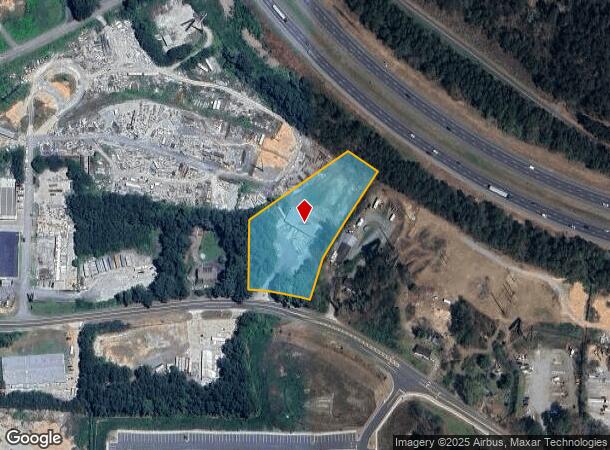
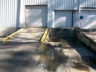
1105 N Highway 293 St Se
0096F-0001-002
Com - Acworth
Industrialgeneral
NORTH COBB INC LL1221 LD21
X
Bartow
13223C0055D
Georgia
2024
2.17 AC
2024
Kennesaw/Acworth
030108
Atlanta
5,400 SF
Atlanta-Sandy Springs-Roswell, GA
DEMOGRAPHICS near 1105 N Highway 293 St Se
1 Mile
3 Mile
5 Mile
2024 Total Population
795
15,672
57,907
2029 Population
876
17,140
62,856
Pop Growth 2024-2029
+ 10.19%
+ 9.37%
+ 8.55%
Average Age
43
41
40
2024 Total Households
320
5,783
20,562
HH Growth 2024-2029
+ 10.00%
+ 8.91%
+ 8.07%
Median Household Inc
$46,892
$78,100
$86,943
Avg Household Size
2.50
2.70
2.80
2024 Avg HH Vehicles
2.00
2.00
2.00
Median Home Value
$76,514
$267,916
$297,415
Median Year Built
1980
1994
1997
Nearby Places
Map Layers
Map Styles
 Street
 Aerial
- Restaurants
- Banks
- Shops
- Fitness
- Groceries
Nearby Properties
Address
Land Use
TOTAL SIZE
Lot Size
Zoning
Address
Land Use
TOTAL SIZE
Lot Size
Zoning
Address
Land Use
TOTAL SIZE
Lot Size
Zoning
28,398 SF
22.95 AC
C1
Address
Land Use
TOTAL SIZE
Lot Size
Zoning
171,050 SF
6.71 AC
Address
Land Use
TOTAL SIZE
Lot Size
Zoning
3,320 SF
78.23 AC
Address
Land Use
TOTAL SIZE
Lot Size
Zoning
61,867 SF
4 AC
Address
Land Use
TOTAL SIZE
Lot Size
Zoning
11.60 AC
IN
Address
Land Use
TOTAL SIZE
Lot Size
Zoning
71,175 SF
30.37 AC
Address
Land Use
TOTAL SIZE
Lot Size
Zoning
35 AC
A1
Address
Land Use
TOTAL SIZE
Lot Size
Zoning
173,600 SF
42.94 AC
Address
Land Use
TOTAL SIZE
Lot Size
Zoning
1,186 SF
3.74 AC
Address
Land Use
TOTAL SIZE
Lot Size
Zoning
69,376 SF
8.52 AC
GC
Address
Land Use
TOTAL SIZE
Lot Size
Zoning
3.76 AC
IN
Address
Land Use
TOTAL SIZE
Lot Size
Zoning
14.09 AC
Address
Land Use
TOTAL SIZE
Lot Size
Zoning
11,945 SF
12.96 AC
Address
Land Use
TOTAL SIZE
Lot Size
Zoning
12,112 SF
5.14 AC
Address
Land Use
TOTAL SIZE
Lot Size
Zoning
47,728 SF
5.45 AC
GC/WS
Address
Land Use
TOTAL SIZE
Lot Size
Zoning
39,464 SF
1.61 AC
Address
Land Use
TOTAL SIZE
Lot Size
Zoning
44,928 SF
5.06 AC
C2/R-7
Address
Land Use
TOTAL SIZE
Lot Size
Zoning
45,045 SF
2.63 AC
Address
Land Use
TOTAL SIZE
Lot Size
Zoning
1,824 SF
68.83 AC
A1
Address
Land Use
TOTAL SIZE
Lot Size
Zoning
31.69 AC
Address
Land Use
TOTAL SIZE
Lot Size
Zoning
86,279 SF
14.26 AC
MU
Address
Land Use
TOTAL SIZE
Lot Size
Zoning
61,857 SF
15.38 AC
C2
Address
Land Use
TOTAL SIZE
Lot Size
Zoning
133,517 SF
9.65 AC
R4
Address
Land Use
TOTAL SIZE
Lot Size
Zoning
600 SF
176.27 AC
A1
Address
Land Use
TOTAL SIZE
Lot Size
Zoning
70,010 SF
2.63 AC
C1
Address
Land Use
TOTAL SIZE
Lot Size
Zoning
Address
Land Use
TOTAL SIZE
Lot Size
Zoning
24.84 AC
Address
Land Use
TOTAL SIZE
Lot Size
Zoning
18,376 SF
5 AC
GC
Address
Land Use
TOTAL SIZE
Lot Size
Zoning
44,256 SF
6.71 AC
RM-8
The World's #1 Commercial Real Estate Marketplace
Connect with us
© 2025 CoStar Group
The information above has been obtained from sources believed reliable. While we do not doubt its accuracy we have not verified it and make no guarantee, warranty or representation about it. It is your responsibility to independently confirm its accuracy and completeness. Any projections, opinions, assumptions, or estimates used are for example only and do not represent the current or future performance of the property. The value of this transaction to you depends on tax and other factors which should be evaluated by your tax, financial, and legal advisors. You and your advisors should conduct a careful, independent investigation of the property to determine to your satisfaction the suitability of the property for your needs.