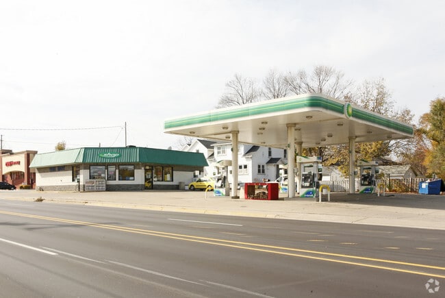
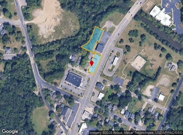
Property Record
1105 N Main St, Adrian, MI 49221

NEARBY LISTINGS FOR SALE OR LEASE
Property Detail
1105 N Main St
Adrian, MI
Assessors Plat
XA0-256-1001-01
LOT 1 AND PART OF LOTS 2, 6, 7 AND 8, BLOCK 11 OF ASSESSOR?S PLAT NO. 11, ACCORDING TO THE PLAT THEREOF RECORDED IN LIBER 5,
Commercialnec
Lenawee
X
Michigan
26091C0191D
1-3,6-8
2024
0.85 AC
2025
Lenawee County
061400
Toledo
1,726 SF
DEMOGRAPHICS near 1105 N Main St
1 Mile
3 Mile
5 Mile
2024 Total Population
8,155
30,411
38,190
2029 Population
8,111
30,118
37,803
Pop Growth 2024-2029
(0.54%)
(0.96%)
(1.01%)
Average Age
40
40
40
2024 Total Households
3,279
11,320
13,915
HH Growth 2024-2029
(0.58%)
(1.04%)
(1.08%)
Median Household Inc
$30,195
$44,865
$49,740
Avg Household Size
2.20
2.30
2.40
2024 Avg HH Vehicles
1.00
2.00
2.00
Median Home Value
$88,746
$126,703
$141,843
Median Year Built
1952
1966
1970
Nearby Places
Map Layers
Map Styles
 Street
 Aerial
- Restaurants
- Banks
- Shops
- Fitness
- Groceries
PUBLIC TRANSPORTATION
AIRPORT
Eugene F Kranz Toledo Express
DRIVE
WALK
Distance
Eugene F Kranz Toledo Express
63 min
35.3 mi
Freight Ports
DRIVE
WALK
Distance
65 min
43.7 mi
Nearby Properties
Address
Land Use
TOTAL SIZE
Lot Size
Zoning
Address
Land Use
TOTAL SIZE
Lot Size
Zoning
198,348 SF
28.50 AC
Address
Land Use
TOTAL SIZE
Lot Size
Zoning
297,470 SF
31.39 AC
I-2
Address
Land Use
TOTAL SIZE
Lot Size
Zoning
19,469 SF
27.08 AC
I-2
Address
Land Use
TOTAL SIZE
Lot Size
Zoning
21.68 AC
B-4
Address
Land Use
TOTAL SIZE
Lot Size
Zoning
Address
Land Use
TOTAL SIZE
Lot Size
Zoning
51,068 SF
7.07 AC
Address
Land Use
TOTAL SIZE
Lot Size
Zoning
122,669 SF
14.27 AC
B-4
Address
Land Use
TOTAL SIZE
Lot Size
Zoning
83,180 SF
3.14 AC
ERO
Address
Land Use
TOTAL SIZE
Lot Size
Zoning
27,436 SF
79.87 AC
CI
Address
Land Use
TOTAL SIZE
Lot Size
Zoning
119,884 SF
9.37 AC
RM-1
Address
Land Use
TOTAL SIZE
Lot Size
Zoning
101,287 SF
16.98 AC
B-4
Address
Land Use
TOTAL SIZE
Lot Size
Zoning
805,326 SF
50.38 AC
Address
Land Use
TOTAL SIZE
Lot Size
Zoning
136,850 SF
10.37 AC
RM-1
Address
Land Use
TOTAL SIZE
Lot Size
Zoning
35,880 SF
2.45 AC
Address
Land Use
TOTAL SIZE
Lot Size
Zoning
512,408 SF
33.83 AC
I-2
Address
Land Use
TOTAL SIZE
Lot Size
Zoning
53,333 SF
6.70 AC
B-4
Address
Land Use
TOTAL SIZE
Lot Size
Zoning
86,479 SF
4.79 AC
Address
Land Use
TOTAL SIZE
Lot Size
Zoning
33,858 SF
14.53 AC
OS-1
Address
Land Use
TOTAL SIZE
Lot Size
Zoning
49,676 SF
0.94 AC
RM-2
Address
Land Use
TOTAL SIZE
Lot Size
Zoning
29.25 AC
B-4
Address
Land Use
TOTAL SIZE
Lot Size
Zoning
42,682 SF
6.41 AC
B-2
Address
Land Use
TOTAL SIZE
Lot Size
Zoning
191,777 SF
6.15 AC
E-1
Address
Land Use
TOTAL SIZE
Lot Size
Zoning
35,534 SF
4.48 AC
Address
Land Use
TOTAL SIZE
Lot Size
Zoning
30,451 SF
7.99 AC
Address
Land Use
TOTAL SIZE
Lot Size
Zoning
73,636 SF
9.99 AC
RM-1
Address
Land Use
TOTAL SIZE
Lot Size
Zoning
86,971 SF
9.56 AC
RM-1
Address
Land Use
TOTAL SIZE
Lot Size
Zoning
17,751 SF
2.76 AC
B-2
Address
Land Use
TOTAL SIZE
Lot Size
Zoning
72,839 SF
7.05 AC
RM-1
Address
Land Use
TOTAL SIZE
Lot Size
Zoning
37.20 AC
Address
Land Use
TOTAL SIZE
Lot Size
Zoning
288,960 SF
20.14 AC
The World's #1 Commercial Real Estate Marketplace
Connect with us
© 2026 CoStar Group
The information above has been obtained from sources believed reliable. While we do not doubt its accuracy we have not verified it and make no guarantee, warranty or representation about it. It is your responsibility to independently confirm its accuracy and completeness. Any projections, opinions, assumptions, or estimates used are for example only and do not represent the current or future performance of the property. The value of this transaction to you depends on tax and other factors which should be evaluated by your tax, financial, and legal advisors. You and your advisors should conduct a careful, independent investigation of the property to determine to your satisfaction the suitability of the property for your needs.