Property Record
1105 Southerland St, Graham, NC 27253
NEARBY LISTINGS FOR SALE OR LEASE
Property Detail
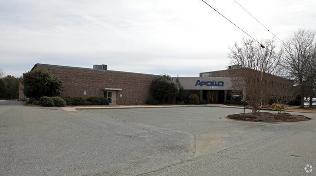
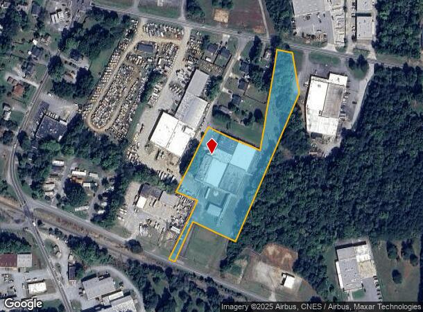
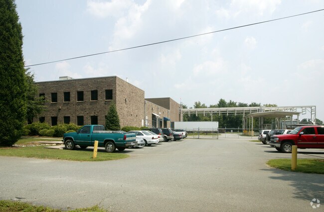
1105 Southerland St
145698
Hazel Knitting Mills Inc
Manufacturinglight
1105 SOUTHERLAND ST 149-583-10
X
Alamance
3710888400K
North Carolina
0
3.62 AC
2025
N Central Alamance County
020302
Greensboro/Winston-Salem
52,308 SF
Burlington, NC
DEMOGRAPHICS near 1105 Southerland St
1 Mile
3 Mile
5 Mile
2024 Total Population
8,408
52,560
88,716
2029 Population
9,034
56,928
95,994
Pop Growth 2024-2029
+ 7.45%
+ 8.31%
+ 8.20%
Average Age
37
39
40
2024 Total Households
3,315
21,261
35,962
HH Growth 2024-2029
+ 7.63%
+ 8.53%
+ 8.37%
Median Household Inc
$33,520
$42,974
$49,799
Avg Household Size
2.40
2.40
2.40
2024 Avg HH Vehicles
2.00
2.00
2.00
Median Home Value
$89,321
$134,024
$163,684
Median Year Built
1964
1972
1976
Nearby Places
Map Layers
Map Styles
 Street
 Aerial
- Restaurants
- Banks
- Shops
- Fitness
- Groceries
PUBLIC TRANSPORTATION
COMMUTER RAIL
Burlington Station (Piedmont - North Carolina by Train (NC Train))
DRIVE
WALK
Distance
Burlington Station (Piedmont - North Carolina by Train (NC Train))
6 min
2.5 mi
AIRPORT
Piedmont Triad International
DRIVE
WALK
Distance
Piedmont Triad International
51 min
34.5 mi
Freight Ports
Virginia Port Authority - Richmond
DRIVE
WALK
Distance
Virginia Port Authority - Richmond
204 min
176.2 mi
Nearby Properties
Address
Land Use
TOTAL SIZE
Lot Size
Zoning
Address
Land Use
TOTAL SIZE
Lot Size
Zoning
2,315 SF
55.43 AC
I 1
Address
Land Use
TOTAL SIZE
Lot Size
Zoning
159,629 SF
82.81 AC
Address
Land Use
TOTAL SIZE
Lot Size
Zoning
27,803 SF
13.10 AC
B 2
Address
Land Use
TOTAL SIZE
Lot Size
Zoning
578,100 SF
55.30 AC
Address
Land Use
TOTAL SIZE
Lot Size
Zoning
48,136 SF
14.57 AC
B 2
Address
Land Use
TOTAL SIZE
Lot Size
Zoning
37,502 SF
17.48 AC
CR
Address
Land Use
TOTAL SIZE
Lot Size
Zoning
27,803 SF
11.53 AC
Address
Land Use
TOTAL SIZE
Lot Size
Zoning
33,280 SF
9.07 AC
I2
Address
Land Use
TOTAL SIZE
Lot Size
Zoning
40,220 SF
12.45 AC
MF A
Address
Land Use
TOTAL SIZE
Lot Size
Zoning
84,881 SF
52.87 AC
I1
Address
Land Use
TOTAL SIZE
Lot Size
Zoning
72,164 SF
73.50 AC
Address
Land Use
TOTAL SIZE
Lot Size
Zoning
714,245 SF
109.43 AC
I 1
Address
Land Use
TOTAL SIZE
Lot Size
Zoning
110,612 SF
1 AC
B 3
Address
Land Use
TOTAL SIZE
Lot Size
Zoning
10,368 SF
11.35 AC
R MF
Address
Land Use
TOTAL SIZE
Lot Size
Zoning
51,994 SF
42.20 AC
OI
Address
Land Use
TOTAL SIZE
Lot Size
Zoning
9,672 SF
10.77 AC
MF A
Address
Land Use
TOTAL SIZE
Lot Size
Zoning
23,992 SF
25.66 AC
R 9
Address
Land Use
TOTAL SIZE
Lot Size
Zoning
19,872 SF
9.80 AC
Address
Land Use
TOTAL SIZE
Lot Size
Zoning
71,962 SF
5.98 AC
O I
Address
Land Use
TOTAL SIZE
Lot Size
Zoning
216,968 SF
25.50 AC
CB
Address
Land Use
TOTAL SIZE
Lot Size
Zoning
40,440 SF
23.57 AC
R 9
Address
Land Use
TOTAL SIZE
Lot Size
Zoning
31,920 SF
4.59 AC
R MF
Address
Land Use
TOTAL SIZE
Lot Size
Zoning
23,268 SF
6.11 AC
Address
Land Use
TOTAL SIZE
Lot Size
Zoning
7,192 SF
14.08 AC
RMF
Address
Land Use
TOTAL SIZE
Lot Size
Zoning
17,073 SF
7.59 AC
R 9
Address
Land Use
TOTAL SIZE
Lot Size
Zoning
15,512 SF
6.54 AC
MF A
Address
Land Use
TOTAL SIZE
Lot Size
Zoning
9,008 SF
6.23 AC
R MF
Address
Land Use
TOTAL SIZE
Lot Size
Zoning
2,923 SF
10.13 AC
Address
Land Use
TOTAL SIZE
Lot Size
Zoning
158,339 SF
16.34 AC
Address
Land Use
TOTAL SIZE
Lot Size
Zoning
77,046 SF
1.61 AC
I 3
The World's #1 Commercial Real Estate Marketplace
Connect with us
© 2025 CoStar Group
The information above has been obtained from sources believed reliable. While we do not doubt its accuracy we have not verified it and make no guarantee, warranty or representation about it. It is your responsibility to independently confirm its accuracy and completeness. Any projections, opinions, assumptions, or estimates used are for example only and do not represent the current or future performance of the property. The value of this transaction to you depends on tax and other factors which should be evaluated by your tax, financial, and legal advisors. You and your advisors should conduct a careful, independent investigation of the property to determine to your satisfaction the suitability of the property for your needs.