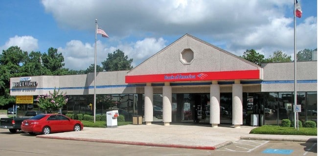
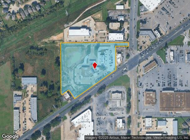
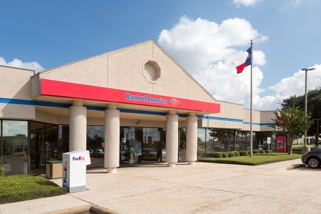
Property Record
11050 Fm 1960 Rd W, Houston, TX 77065
NEARBY LISTINGS FOR SALE OR LEASE
Property Detail
11050 Fm 1960 Rd W
0432190000029
Colina Steeplechase
Outdoorrecreationbeachmountaindesert
RES A BLK 1 COLINA STEEPLECHASE
X
Harris
48201C0440N
Texas
2024
5.43 AC
2025
Fairfield
552401
Houston
16,112 SF
Houston-The Woodlands-Sugar Land, TX
DEMOGRAPHICS near 11050 Fm 1960 Rd W
1 Mile
3 Mile
5 Mile
2024 Total Population
11,937
109,220
248,988
2029 Population
12,124
110,634
252,113
Pop Growth 2024-2029
+ 1.57%
+ 1.29%
+ 1.26%
Average Age
39
37
38
2024 Total Households
4,165
40,547
91,221
HH Growth 2024-2029
+ 1.63%
+ 1.19%
+ 1.23%
Median Household Inc
$53,193
$67,388
$75,046
Avg Household Size
2.70
2.60
2.70
2024 Avg HH Vehicles
2.00
2.00
2.00
Median Home Value
$197,090
$222,474
$243,295
Median Year Built
1988
1993
1993
Nearby Places
- Restaurants
- Banks
- Shops
- Fitness
- Groceries
PUBLIC TRANSPORTATION
AIRPORT
George Bush Intcntl/Houston
DRIVE
WALK
Distance
George Bush Intcntl/Houston
27 min
19.7 mi
William P Hobby
DRIVE
WALK
Distance
William P Hobby
53 min
34.7 mi
Freight Ports
Port of Houston
DRIVE
WALK
Distance
Port of Houston
45 min
30.3 mi
SALE & LEASE HISTORY
LISTING DATE
SALE/LEASE

Sep 24, 2016
For Sale
Nearby Properties
Address
Land Use
TOTAL SIZE
Lot Size
Zoning
Address
Land Use
TOTAL SIZE
Lot Size
Zoning
1,421,980 SF
147.83 AC
Address
Land Use
TOTAL SIZE
Lot Size
Zoning
311,285 SF
14.47 AC
Address
Land Use
TOTAL SIZE
Lot Size
Zoning
778,140 SF
40.25 AC
Address
Land Use
TOTAL SIZE
Lot Size
Zoning
660,000 SF
104.88 AC
Address
Land Use
TOTAL SIZE
Lot Size
Zoning
682,700 SF
37 AC
Address
Land Use
TOTAL SIZE
Lot Size
Zoning
625,701 SF
52.20 AC
Address
Land Use
TOTAL SIZE
Lot Size
Zoning
388,333 SF
41.17 AC
Address
Land Use
TOTAL SIZE
Lot Size
Zoning
664,361 SF
39.18 AC
Address
Land Use
TOTAL SIZE
Lot Size
Zoning
466,299 SF
23.82 AC
Address
Land Use
TOTAL SIZE
Lot Size
Zoning
373,516 SF
18.63 AC
Address
Land Use
TOTAL SIZE
Lot Size
Zoning
266,802 SF
3.14 AC
Address
Land Use
TOTAL SIZE
Lot Size
Zoning
408,710 SF
4.49 AC
Address
Land Use
TOTAL SIZE
Lot Size
Zoning
426,203 SF
23.88 AC
Address
Land Use
TOTAL SIZE
Lot Size
Zoning
301,119 SF
9.92 AC
Address
Land Use
TOTAL SIZE
Lot Size
Zoning
471,800 SF
27.03 AC
Address
Land Use
TOTAL SIZE
Lot Size
Zoning
307,698 SF
13.12 AC
Address
Land Use
TOTAL SIZE
Lot Size
Zoning
449,032 SF
23.46 AC
Address
Land Use
TOTAL SIZE
Lot Size
Zoning
387,245 SF
18.18 AC
Address
Land Use
TOTAL SIZE
Lot Size
Zoning
339,301 SF
68.40 AC
Address
Land Use
TOTAL SIZE
Lot Size
Zoning
365,711 SF
26.61 AC
Address
Land Use
TOTAL SIZE
Lot Size
Zoning
151,314 SF
3.88 AC
Address
Land Use
TOTAL SIZE
Lot Size
Zoning
441,000 SF
23.07 AC
Address
Land Use
TOTAL SIZE
Lot Size
Zoning
469,370 SF
19.39 AC
Address
Land Use
TOTAL SIZE
Lot Size
Zoning
402,712 SF
25.64 AC
Address
Land Use
TOTAL SIZE
Lot Size
Zoning
375,251 SF
14.85 AC
Address
Land Use
TOTAL SIZE
Lot Size
Zoning
326,807 SF
29.43 AC
Address
Land Use
TOTAL SIZE
Lot Size
Zoning
463,932 SF
26.62 AC
Address
Land Use
TOTAL SIZE
Lot Size
Zoning
433,984 SF
17.82 AC
Address
Land Use
TOTAL SIZE
Lot Size
Zoning
368,361 SF
23.95 AC
Address
Land Use
TOTAL SIZE
Lot Size
Zoning
384,280 SF
27.19 AC
The World's #1 Commercial Real Estate Marketplace
Connect with us
© 2025 CoStar Group
The information above has been obtained from sources believed reliable. While we do not doubt its accuracy we have not verified it and make no guarantee, warranty or representation about it. It is your responsibility to independently confirm its accuracy and completeness. Any projections, opinions, assumptions, or estimates used are for example only and do not represent the current or future performance of the property. The value of this transaction to you depends on tax and other factors which should be evaluated by your tax, financial, and legal advisors. You and your advisors should conduct a careful, independent investigation of the property to determine to your satisfaction the suitability of the property for your needs.