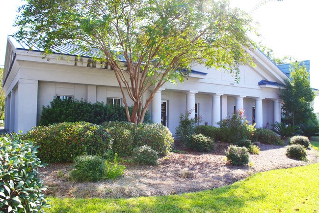
Property Record
1106 Saint Andrews Blvd, Charleston, SC 29407


NEARBY LISTINGS FOR SALE OR LEASE
Property Detail
1106 Saint Andrews Blvd
Charleston-North Charleston, SC
Hillside
418-06-00-086
SUBDIVISION NAME -HILLSIDE DESCRIPTION -LOT 1A SITE NAME -CAROLINA FEDERAL SAVINGS BANK
Officebuilding
Charleston
AE
South Carolina
45019C0511K
1a
2025
0.33 AC
2024
West Ashley
002605
Charleston/N Charleston
3,946 SF
DEMOGRAPHICS near 1106 Saint Andrews Blvd
1 Mile
3 Mile
5 Mile
2024 Total Population
8,872
64,320
140,136
2029 Population
9,444
68,932
150,764
Pop Growth 2024-2029
+ 6.45%
+ 7.17%
+ 7.58%
Average Age
41
39
39
2024 Total Households
4,168
29,820
62,601
HH Growth 2024-2029
+ 6.26%
+ 7.13%
+ 7.53%
Median Household Inc
$54,089
$67,520
$64,868
Avg Household Size
2.10
2.00
2.10
2024 Avg HH Vehicles
2.00
2.00
2.00
Median Home Value
$289,327
$399,640
$381,889
Median Year Built
1967
1971
1975
Nearby Places
Map Layers
Map Styles
 Street
 Aerial
- Restaurants
- Banks
- Shops
- Fitness
- Groceries
PUBLIC TRANSPORTATION
COMMUTER RAIL
DRIVE
WALK
Distance
10 min
6.2 mi
AIRPORT
Charleston AFB/International
DRIVE
WALK
Distance
Charleston AFB/International
19 min
11.8 mi
Freight Ports
Columbus Street Terminal
DRIVE
WALK
Distance
Columbus Street Terminal
9 min
4.5 mi
SALE & LEASE HISTORY
LISTING DATE
SALE/LEASE

Apr 04, 2024
For Lease
Nearby Properties
Address
Land Use
TOTAL SIZE
Lot Size
Zoning
Address
Land Use
TOTAL SIZE
Lot Size
Zoning
79,990 SF
9.22 AC
Address
Land Use
TOTAL SIZE
Lot Size
Zoning
0.62 AC
Address
Land Use
TOTAL SIZE
Lot Size
Zoning
9,778 SF
11.90 AC
Address
Land Use
TOTAL SIZE
Lot Size
Zoning
80,044 SF
2.48 AC
Address
Land Use
TOTAL SIZE
Lot Size
Zoning
21,900 SF
5.96 AC
Address
Land Use
TOTAL SIZE
Lot Size
Zoning
Address
Land Use
TOTAL SIZE
Lot Size
Zoning
66,136 SF
1.88 AC
Address
Land Use
TOTAL SIZE
Lot Size
Zoning
11,631 SF
8 AC
Address
Land Use
TOTAL SIZE
Lot Size
Zoning
78,810 SF
3.33 AC
Address
Land Use
TOTAL SIZE
Lot Size
Zoning
1,435 SF
1.98 AC
Address
Land Use
TOTAL SIZE
Lot Size
Zoning
5.54 AC
Address
Land Use
TOTAL SIZE
Lot Size
Zoning
8,714 SF
1.60 AC
Address
Land Use
TOTAL SIZE
Lot Size
Zoning
30,196 SF
1.58 AC
Address
Land Use
TOTAL SIZE
Lot Size
Zoning
Address
Land Use
TOTAL SIZE
Lot Size
Zoning
Address
Land Use
TOTAL SIZE
Lot Size
Zoning
3,275 SF
4.18 AC
Address
Land Use
TOTAL SIZE
Lot Size
Zoning
43,934 SF
1.50 AC
Address
Land Use
TOTAL SIZE
Lot Size
Zoning
14,240 SF
3.50 AC
Address
Land Use
TOTAL SIZE
Lot Size
Zoning
3,520 SF
7.70 AC
Address
Land Use
TOTAL SIZE
Lot Size
Zoning
29,910 SF
2.82 AC
Address
Land Use
TOTAL SIZE
Lot Size
Zoning
41,070 SF
0.61 AC
Address
Land Use
TOTAL SIZE
Lot Size
Zoning
Address
Land Use
TOTAL SIZE
Lot Size
Zoning
22,825 SF
4.36 AC
Address
Land Use
TOTAL SIZE
Lot Size
Zoning
257,500 SF
4.72 AC
Address
Land Use
TOTAL SIZE
Lot Size
Zoning
Address
Land Use
TOTAL SIZE
Lot Size
Zoning
Address
Land Use
TOTAL SIZE
Lot Size
Zoning
26,010 SF
4.32 AC
Address
Land Use
TOTAL SIZE
Lot Size
Zoning
7.09 AC
Address
Land Use
TOTAL SIZE
Lot Size
Zoning
1,056 SF
1.65 AC
Address
Land Use
TOTAL SIZE
Lot Size
Zoning
12,777 SF
2.36 AC
The World's #1 Commercial Real Estate Marketplace
Connect with us
© 2026 CoStar Group
The information above has been obtained from sources believed reliable. While we do not doubt its accuracy we have not verified it and make no guarantee, warranty or representation about it. It is your responsibility to independently confirm its accuracy and completeness. Any projections, opinions, assumptions, or estimates used are for example only and do not represent the current or future performance of the property. The value of this transaction to you depends on tax and other factors which should be evaluated by your tax, financial, and legal advisors. You and your advisors should conduct a careful, independent investigation of the property to determine to your satisfaction the suitability of the property for your needs.