Property Record
11060 Wilson Rd, New Buffalo, MI 49117
NEARBY LISTINGS FOR SALE OR LEASE
-
-
View all New Buffalo listings for sale on LoopNet.com
Property Detail
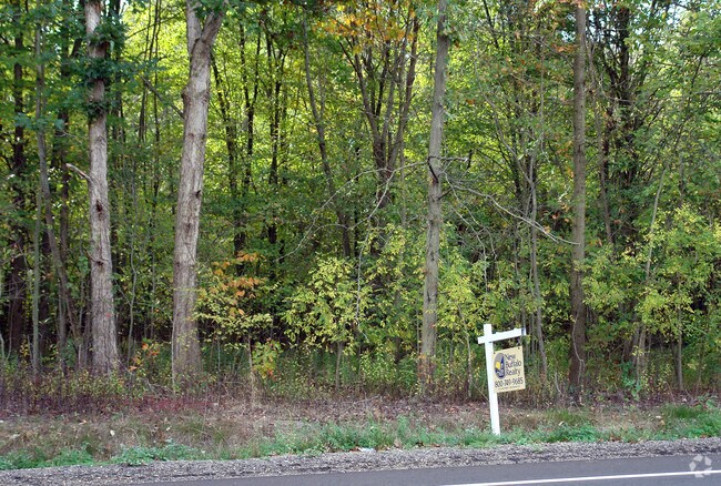
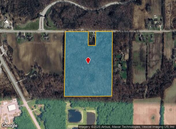
11060 Wilson Rd
11-13-0023-0003-04-4
THE NE1/4 OF NW1/4 FRL SEC 23 T8S R21W EXC THE E 350' THEREOF ALSO EXC COM 697.86' W OF N1/4 PST SEC 23 TH W 140'TH S 287'TH E 140'TH N 287'TO POB
Residentialacreage
Berrien
A
Michigan
18091C0075D
29.68 AC
2024
Michigan Southwest Area
2025
Other Market Areas
011301
Niles-Benton Harbor, MI
DEMOGRAPHICS near 11060 Wilson Rd
1 Mile
3 Mile
5 Mile
2024 Total Population
55
4,786
10,252
2029 Population
59
5,036
10,767
Pop Growth 2024-2029
+ 7.27%
+ 5.22%
+ 5.02%
Average Age
49
48
49
2024 Total Households
26
2,212
4,679
HH Growth 2024-2029
+ 3.85%
+ 5.33%
+ 5.26%
Median Household Inc
$67,500
$67,862
$72,657
Avg Household Size
2.20
2.10
2.20
2024 Avg HH Vehicles
2.00
2.00
2.00
Median Home Value
$399,999
$323,204
$331,887
Median Year Built
1988
1977
1979
Nearby Places
Map Layers
Map Styles
 Street
 Aerial
- Restaurants
- Banks
- Shops
- Fitness
- Groceries
PUBLIC TRANSPORTATION
COMMUTER RAIL
New Buffalo Amtrak (Blue Water - Amtrak, Wolverine - Amtrak)
DRIVE
WALK
Distance
New Buffalo Amtrak (Blue Water - Amtrak, Wolverine - Amtrak)
5 min
2.5 mi
AIRPORT
South Bend International
DRIVE
WALK
Distance
South Bend International
53 min
31.8 mi
Freight Ports
Port Milwaukee
DRIVE
WALK
Distance
Port Milwaukee
189 min
154.5 mi
Nearby Properties
Address
Land Use
TOTAL SIZE
Lot Size
Zoning
Address
Land Use
TOTAL SIZE
Lot Size
Zoning
29,124 SF
14.50 AC
I-1
Address
Land Use
TOTAL SIZE
Lot Size
Zoning
9,000 SF
10.19 AC
GCD
Address
Land Use
TOTAL SIZE
Lot Size
Zoning
44,978 SF
2.08 AC
C-2
Address
Land Use
TOTAL SIZE
Lot Size
Zoning
61,856 SF
2.52 AC
C-2
Address
Land Use
TOTAL SIZE
Lot Size
Zoning
30,221 SF
23.62 AC
Address
Land Use
TOTAL SIZE
Lot Size
Zoning
11,534 SF
80 AC
Address
Land Use
TOTAL SIZE
Lot Size
Zoning
35,378 SF
3.94 AC
SELECTZONI
Address
Land Use
TOTAL SIZE
Lot Size
Zoning
43,365 SF
2.40 AC
SELECTZONI
Address
Land Use
TOTAL SIZE
Lot Size
Zoning
8,998 SF
2.73 AC
GCD
Address
Land Use
TOTAL SIZE
Lot Size
Zoning
7,464 SF
2.40 AC
GCD
Address
Land Use
TOTAL SIZE
Lot Size
Zoning
14,642 SF
0.30 AC
CBD
Address
Land Use
TOTAL SIZE
Lot Size
Zoning
0.57 AC
R-1
Address
Land Use
TOTAL SIZE
Lot Size
Zoning
0.57 AC
R-1
Address
Land Use
TOTAL SIZE
Lot Size
Zoning
0.57 AC
R-1
Address
Land Use
TOTAL SIZE
Lot Size
Zoning
70,091 SF
15.94 AC
SELECTZONI
Address
Land Use
TOTAL SIZE
Lot Size
Zoning
8,680 SF
5.10 AC
SELECTZONI
Address
Land Use
TOTAL SIZE
Lot Size
Zoning
0.20 AC
Address
Land Use
TOTAL SIZE
Lot Size
Zoning
15,198 SF
0.80 AC
CBD
Address
Land Use
TOTAL SIZE
Lot Size
Zoning
0.76 AC
WM
Address
Land Use
TOTAL SIZE
Lot Size
Zoning
21,854 SF
0.70 AC
CBD
Address
Land Use
TOTAL SIZE
Lot Size
Zoning
7,910 SF
0.41 AC
CBD
Address
Land Use
TOTAL SIZE
Lot Size
Zoning
3,721 SF
2.50 AC
GCD
Address
Land Use
TOTAL SIZE
Lot Size
Zoning
48,919 SF
232.10 AC
SELECTZONI
Address
Land Use
TOTAL SIZE
Lot Size
Zoning
28,841 SF
8.98 AC
Address
Land Use
TOTAL SIZE
Lot Size
Zoning
5,111 SF
0.80 AC
CBD
Address
Land Use
TOTAL SIZE
Lot Size
Zoning
2.40 AC
GCD
Address
Land Use
TOTAL SIZE
Lot Size
Zoning
8,136 SF
30.41 AC
Address
Land Use
TOTAL SIZE
Lot Size
Zoning
2,736 SF
205.83 AC
SELECTZONI
Address
Land Use
TOTAL SIZE
Lot Size
Zoning
7,342 SF
26.09 AC
The World's #1 Commercial Real Estate Marketplace
Connect with us
© 2025 CoStar Group
The information above has been obtained from sources believed reliable. While we do not doubt its accuracy we have not verified it and make no guarantee, warranty or representation about it. It is your responsibility to independently confirm its accuracy and completeness. Any projections, opinions, assumptions, or estimates used are for example only and do not represent the current or future performance of the property. The value of this transaction to you depends on tax and other factors which should be evaluated by your tax, financial, and legal advisors. You and your advisors should conduct a careful, independent investigation of the property to determine to your satisfaction the suitability of the property for your needs.