Property Record
1107 Shaver St, Pasadena, TX 77506
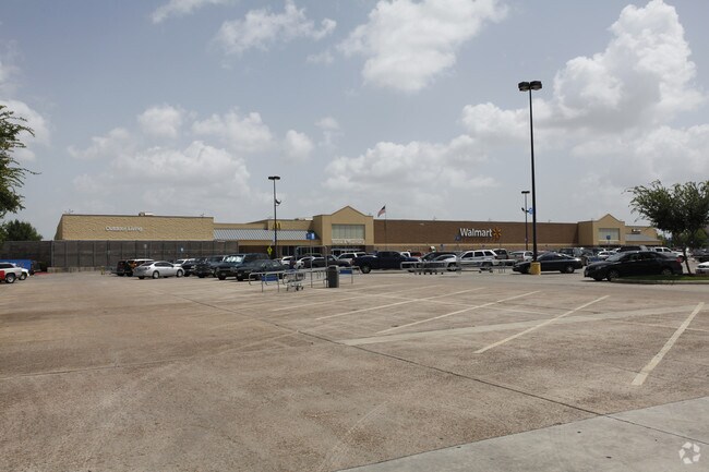

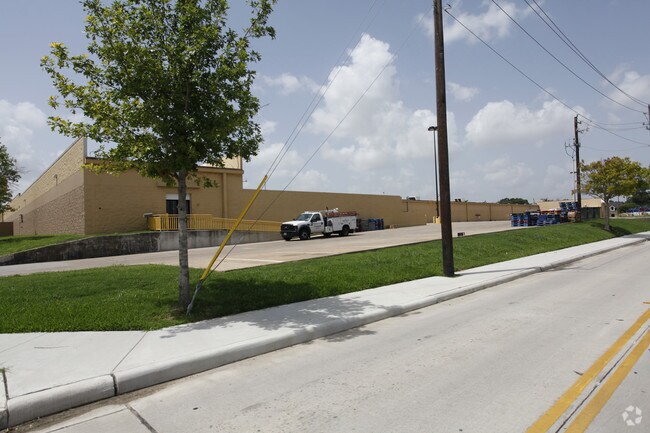
Property Detail
1107 Shaver St
1201080010001
RES A BLK 1 PASADENA ORIGINAL
Departmentstore
HARRIS
B and X Area of moderate flood hazard, usually the area between the limits of the 100-year and 500-year floods.
Texas
2024
15.79 AC
2025
Near Southeast
322100
Houston
207,056 SF
Houston-Pasadena-The Woodlands, TX
NEARBY LISTINGS FOR SALE OR LEASE
DEMOGRAPHICS near 1107 Shaver St
1 mile
3 mile
5 mile
2025 Total Population
22,242
127,784
301,380
2030 Population
23,929
136,311
322,101
Pop Growth 2025-2030
+ 7.58%
+ 6.67%
+ 6.88%
Average Age
34
35
36
2025 Total Households
6,753
39,858
97,637
HH Growth 2025-2030
+ 7.94%
+ 6.90%
+ 7.13%
Median Household Inc
$47,292
$56,337
$55,160
Avg Household Size
3.20
3.10
3.00
2025 Avg HH Vehicles
2.00
2.00
2.00
Median Home Value
$168,838
$176,217
$187,722
Median Year Built
1963
1966
1971
Nearby Places
Map Layers
Map Styles
 Street
 Aerial
Layers
 Traffic
 Biking
Places
Listings with unknown addresses are not visible on the map
- Restaurants
- Banks
- Shops
- Fitness
- Groceries
PUBLIC TRANSPORTATION
AIRPORT
William P Hobby
Drive
Walk
Distance
William P Hobby
20 min
8.0 mi
George Bush Intcntl/Houston
Drive
Walk
Distance
George Bush Intcntl/Houston
40 min
29.4 mi
Freight Ports
Port of Houston
Drive
Walk
Distance
Port of Houston
15 min
7.8 mi
Nearby Properties
Address
Land Use
TOTAL SIZE
Lot Size
Zoning
Address
Land Use
TOTAL SIZE
Lot Size
Zoning
Address
Land Use
TOTAL SIZE
Lot Size
Zoning
65.22 AC
Address
Land Use
TOTAL SIZE
Lot Size
Zoning
256.70 AC
Address
Land Use
TOTAL SIZE
Lot Size
Zoning
134.46 AC
Address
Land Use
TOTAL SIZE
Lot Size
Zoning
4,574,044 SF
102.55 AC
Address
Land Use
TOTAL SIZE
Lot Size
Zoning
592,980 SF
20 AC
Address
Land Use
TOTAL SIZE
Lot Size
Zoning
143.17 AC
Address
Land Use
TOTAL SIZE
Lot Size
Zoning
2,019,000 SF
20 AC
Address
Land Use
TOTAL SIZE
Lot Size
Zoning
3,934,000 SF
Address
Land Use
TOTAL SIZE
Lot Size
Zoning
1,476,300 SF
39.05 AC
Address
Land Use
TOTAL SIZE
Lot Size
Zoning
4.26 AC
Address
Land Use
TOTAL SIZE
Lot Size
Zoning
165.53 AC
Address
Land Use
TOTAL SIZE
Lot Size
Zoning
72.68 AC
Address
Land Use
TOTAL SIZE
Lot Size
Zoning
3,568,104 SF
61.61 AC
Address
Land Use
TOTAL SIZE
Lot Size
Zoning
345,420 SF
4.02 AC
Address
Land Use
TOTAL SIZE
Lot Size
Zoning
115.83 AC
Address
Land Use
TOTAL SIZE
Lot Size
Zoning
2,918,000 SF
69.31 AC
Address
Land Use
TOTAL SIZE
Lot Size
Zoning
1,978,100 SF
50.02 AC
Address
Land Use
TOTAL SIZE
Lot Size
Zoning
4,580,000 SF
42.82 AC
Address
Land Use
TOTAL SIZE
Lot Size
Zoning
2,367,893 SF
39.85 AC
Address
Land Use
TOTAL SIZE
Lot Size
Zoning
403,776 SF
21.06 AC
Address
Land Use
TOTAL SIZE
Lot Size
Zoning
218,787 SF
10 AC
Address
Land Use
TOTAL SIZE
Lot Size
Zoning
2,778,876 SF
51.42 AC
Address
Land Use
TOTAL SIZE
Lot Size
Zoning
281,470 SF
11.24 AC
Address
Land Use
TOTAL SIZE
Lot Size
Zoning
1,149,387 SF
36.61 AC
Address
Land Use
TOTAL SIZE
Lot Size
Zoning
Address
Land Use
TOTAL SIZE
Lot Size
Zoning
397,739 SF
15.93 AC
Address
Land Use
TOTAL SIZE
Lot Size
Zoning
504,938 SF
28.96 AC
Address
Land Use
TOTAL SIZE
Lot Size
Zoning
363,740 SF
16.92 AC
Address
Land Use
TOTAL SIZE
Lot Size
Zoning
143.17 AC
The World's #1 Commercial Real Estate Marketplace
Connect with us
© 2026 CoStar Group
The information above has been obtained from sources believed reliable. While we do not doubt its accuracy we have not verified it and make no guarantee, warranty or representation about it. It is your responsibility to independently confirm its accuracy and completeness. Any projections, opinions, assumptions, or estimates used are for example only and do not represent the current or future performance of the property. The value of this transaction to you depends on tax and other factors which should be evaluated by your tax, financial, and legal advisors. You and your advisors should conduct a careful, independent investigation of the property to determine to your satisfaction the suitability of the property for your needs.