Property Record
11070 Blasius Rd, Jacksonville, FL 32226
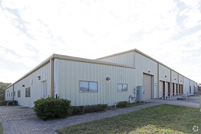


Property Detail
11070 Blasius Rd
109090-0100
1-18 39-1S-27E 7.8 DOMINGO FERNANDEZ GRANT S/D PT LOT 13 RECD O/R 20283-199
Warehouse
Duval
IH
Florida
AE The base floodplain where base flood elevations are provided. AE Zones are now used on new format FIRMs instead of A1-A30 Zones.
13
2025
7.80 AC
2026
Ocean Way
010104
Jacksonville (Florida)
32,910 SF
Jacksonville, FL
NEARBY LISTINGS FOR SALE OR LEASE
DEMOGRAPHICS near 11070 Blasius Rd
1 mile
3 mile
5 mile
2025 Total Population
758
14,327
60,846
2030 Population
829
15,318
64,525
Pop Growth 2025-2030
+ 9.37%
+ 6.92%
+ 6.05%
Average Age
40
39
39
2025 Total Households
288
5,226
22,918
HH Growth 2025-2030
+ 9.72%
+ 7.29%
+ 6.38%
Median Household Inc
$111,659
$94,827
$82,572
Avg Household Size
2.60
2.70
2.60
2025 Avg HH Vehicles
2.00
2.00
2.00
Median Home Value
$374,799
$372,609
$338,331
Median Year Built
2004
2004
1996
Nearby Places
Map Layers
Map Styles
 Street
 Aerial
Layers
 Traffic
 Biking
Places
Listings with unknown addresses are not visible on the map
- Restaurants
- Banks
- Shops
- Fitness
- Groceries
PUBLIC TRANSPORTATION
AIRPORT
Jacksonville International
Drive
Walk
Distance
Jacksonville International
20 min
10.6 mi
SALE & LEASE HISTORY
LISTING DATE
SALE/LEASE

Sep 25, 2016
For Lease
Mar 07, 2022
For Sale
Jun 05, 2018
For Lease
Dec 14, 2021
For Lease
Aug 09, 2017
For Lease
Nearby Properties
Address
Land Use
TOTAL SIZE
Lot Size
Zoning
Address
Land Use
TOTAL SIZE
Lot Size
Zoning
437 SF
304.61 AC
PBF-1
Address
Land Use
TOTAL SIZE
Lot Size
Zoning
60,843 SF
345.03 AC
IW
Address
Land Use
TOTAL SIZE
Lot Size
Zoning
608,297 SF
49.09 AC
IBP
Address
Land Use
TOTAL SIZE
Lot Size
Zoning
181,827 SF
269.11 AC
IW
Address
Land Use
TOTAL SIZE
Lot Size
Zoning
350,831 SF
23.77 AC
IH
Address
Land Use
TOTAL SIZE
Lot Size
Zoning
877,268 SF
77.25 AC
IL
Address
Land Use
TOTAL SIZE
Lot Size
Zoning
816,362 SF
54.68 AC
IH
Address
Land Use
TOTAL SIZE
Lot Size
Zoning
353,240 SF
26.17 AC
PUD
Address
Land Use
TOTAL SIZE
Lot Size
Zoning
350,581 SF
75.99 AC
IH
Address
Land Use
TOTAL SIZE
Lot Size
Zoning
841,077 SF
241.17 AC
PUD
Address
Land Use
TOTAL SIZE
Lot Size
Zoning
324,922 SF
19.11 AC
PUD
Address
Land Use
TOTAL SIZE
Lot Size
Zoning
2,865 SF
958.93 AC
PBF-1
Address
Land Use
TOTAL SIZE
Lot Size
Zoning
365,585 SF
27.53 AC
PUD
Address
Land Use
TOTAL SIZE
Lot Size
Zoning
239,260 SF
36.84 AC
PUD
Address
Land Use
TOTAL SIZE
Lot Size
Zoning
283,824 SF
24.77 AC
PUD
Address
Land Use
TOTAL SIZE
Lot Size
Zoning
237,480 SF
19.61 AC
PUD
Address
Land Use
TOTAL SIZE
Lot Size
Zoning
67,866 SF
81.07 AC
IW
Address
Land Use
TOTAL SIZE
Lot Size
Zoning
221,465 SF
13.54 AC
PUD
Address
Land Use
TOTAL SIZE
Lot Size
Zoning
63,266 SF
75.60 AC
IW
Address
Land Use
TOTAL SIZE
Lot Size
Zoning
69,794 SF
24.21 AC
PUD
Address
Land Use
TOTAL SIZE
Lot Size
Zoning
210,402 SF
9.50 AC
PUD
Address
Land Use
TOTAL SIZE
Lot Size
Zoning
428,002 SF
72.39 AC
IW
Address
Land Use
TOTAL SIZE
Lot Size
Zoning
189,392 SF
13.66 AC
PUD
Address
Land Use
TOTAL SIZE
Lot Size
Zoning
181,545 SF
15.02 AC
PUD
Address
Land Use
TOTAL SIZE
Lot Size
Zoning
669.93 AC
PBF-1
Address
Land Use
TOTAL SIZE
Lot Size
Zoning
196,536 SF
10.59 AC
IH
Address
Land Use
TOTAL SIZE
Lot Size
Zoning
77,745 SF
10.92 AC
PUD
Address
Land Use
TOTAL SIZE
Lot Size
Zoning
114,420 SF
24.30 AC
IH
Address
Land Use
TOTAL SIZE
Lot Size
Zoning
134,410 SF
9.75 AC
PUD
Address
Land Use
TOTAL SIZE
Lot Size
Zoning
56,666 SF
5.57 AC
IH
The World's #1 Commercial Real Estate Marketplace
Connect with us
© 2026 CoStar Group
The information above has been obtained from sources believed reliable. While we do not doubt its accuracy we have not verified it and make no guarantee, warranty or representation about it. It is your responsibility to independently confirm its accuracy and completeness. Any projections, opinions, assumptions, or estimates used are for example only and do not represent the current or future performance of the property. The value of this transaction to you depends on tax and other factors which should be evaluated by your tax, financial, and legal advisors. You and your advisors should conduct a careful, independent investigation of the property to determine to your satisfaction the suitability of the property for your needs.