Property Record
11074 W Tonto St, Avondale, AZ 85323


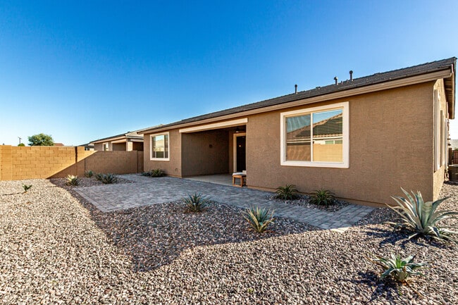
This Property Is For Sale
NEARBY LISTINGS FOR SALE OR LEASE
-
-
View all Avondale listings for sale on LoopNet.com
Property Detail
11074 W Tonto St
Phoenix-Mesa-Scottsdale, AZ
Vista Del Verde Phase 4 Replat
101-09-498
VISTA DEL VERDE PHASE 4 REPLAT MCR 1529-37
Vacantlandnec
Maricopa
X
Arizona
04013C2170N
55
2025
0.17 AC
2025
Glendale
082027
Phoenix
DEMOGRAPHICS near 11074 W Tonto St
1 Mile
3 Mile
5 Mile
2024 Total Population
15,954
98,233
217,858
2029 Population
17,094
106,225
235,935
Pop Growth 2024-2029
+ 7.15%
+ 8.14%
+ 8.30%
Average Age
32
32
33
2024 Total Households
4,285
28,172
63,684
HH Growth 2024-2029
+ 7.35%
+ 8.26%
+ 8.38%
Median Household Inc
$77,321
$74,461
$74,106
Avg Household Size
3.60
3.40
3.30
2024 Avg HH Vehicles
2.00
2.00
2.00
Median Home Value
$281,034
$302,045
$305,162
Median Year Built
2004
2003
2001
Nearby Places
Map Layers
Map Styles
 Street
 Aerial
- Restaurants
- Banks
- Shops
- Fitness
- Groceries
PUBLIC TRANSPORTATION
AIRPORT
Phoenix Sky Harbor International
DRIVE
WALK
Distance
Phoenix Sky Harbor International
30 min
20.5 mi
Nearby Properties
Address
Land Use
TOTAL SIZE
Lot Size
Zoning
Address
Land Use
TOTAL SIZE
Lot Size
Zoning
12.04 AC
Address
Land Use
TOTAL SIZE
Lot Size
Zoning
12.80 AC
Address
Land Use
TOTAL SIZE
Lot Size
Zoning
206.08 AC
PAD
Address
Land Use
TOTAL SIZE
Lot Size
Zoning
Address
Land Use
TOTAL SIZE
Lot Size
Zoning
Address
Land Use
TOTAL SIZE
Lot Size
Zoning
889,089 SF
83.11 AC
I-1
Address
Land Use
TOTAL SIZE
Lot Size
Zoning
134.65 AC
S1
Address
Land Use
TOTAL SIZE
Lot Size
Zoning
90,008 SF
20.42 AC
M-H
Address
Land Use
TOTAL SIZE
Lot Size
Zoning
177,052 SF
2.69 AC
THEBLVDD
Address
Land Use
TOTAL SIZE
Lot Size
Zoning
728,550 SF
41.98 AC
Address
Land Use
TOTAL SIZE
Lot Size
Zoning
287,294 SF
67.46 AC
PAD
Address
Land Use
TOTAL SIZE
Lot Size
Zoning
301,329 SF
50.60 AC
AG
Address
Land Use
TOTAL SIZE
Lot Size
Zoning
763,410 SF
45.50 AC
Address
Land Use
TOTAL SIZE
Lot Size
Zoning
369,413 SF
16.39 AC
THEBLVDD
Address
Land Use
TOTAL SIZE
Lot Size
Zoning
466,868 SF
45.99 AC
I-1
Address
Land Use
TOTAL SIZE
Lot Size
Zoning
432,022 SF
19.33 AC
PAD
Address
Land Use
TOTAL SIZE
Lot Size
Zoning
797,310 SF
36.82 AC
I-1
Address
Land Use
TOTAL SIZE
Lot Size
Zoning
628,480 SF
34.45 AC
PAD
Address
Land Use
TOTAL SIZE
Lot Size
Zoning
660,980 SF
40.15 AC
Address
Land Use
TOTAL SIZE
Lot Size
Zoning
397,132 SF
27.52 AC
I1
Address
Land Use
TOTAL SIZE
Lot Size
Zoning
487,424 SF
30.05 AC
CPGCP
Address
Land Use
TOTAL SIZE
Lot Size
Zoning
409,088 SF
21.34 AC
PAD
Address
Land Use
TOTAL SIZE
Lot Size
Zoning
630,285 SF
36.02 AC
R-43AG
Address
Land Use
TOTAL SIZE
Lot Size
Zoning
13.45 AC
Address
Land Use
TOTAL SIZE
Lot Size
Zoning
386,100 SF
21.13 AC
I-2
Address
Land Use
TOTAL SIZE
Lot Size
Zoning
327,840 SF
22.20 AC
PAD
Address
Land Use
TOTAL SIZE
Lot Size
Zoning
535,852 SF
31.22 AC
I-1
Address
Land Use
TOTAL SIZE
Lot Size
Zoning
332,075 SF
19.15 AC
C2
Address
Land Use
TOTAL SIZE
Lot Size
Zoning
274,700 SF
23.23 AC
PAD
The World's #1 Commercial Real Estate Marketplace
Connect with us
© 2025 CoStar Group
The information above has been obtained from sources believed reliable. While we do not doubt its accuracy we have not verified it and make no guarantee, warranty or representation about it. It is your responsibility to independently confirm its accuracy and completeness. Any projections, opinions, assumptions, or estimates used are for example only and do not represent the current or future performance of the property. The value of this transaction to you depends on tax and other factors which should be evaluated by your tax, financial, and legal advisors. You and your advisors should conduct a careful, independent investigation of the property to determine to your satisfaction the suitability of the property for your needs.