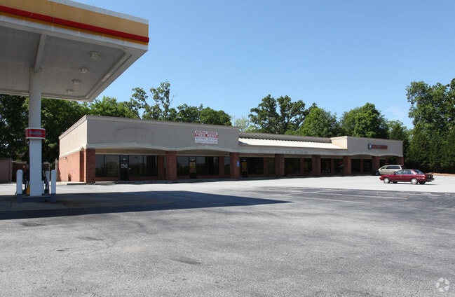
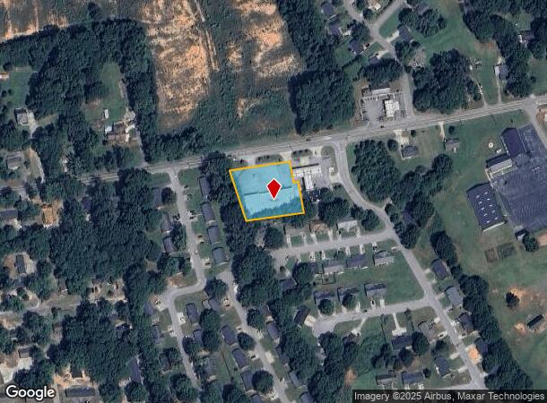
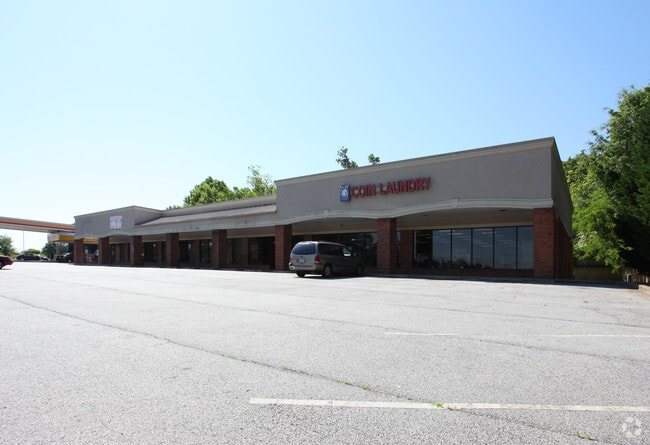
Property Record
1114 E Church St, Monroe, GA 30655

Current Lease Availabilities
NEARBY LISTINGS FOR SALE OR LEASE
Property Detail
1114 E Church St
M025000000134000
09162-Monroe Spot 2.20
Commercialnec
.99AC
X
Walton
13297C0137F
Georgia
2024
0.99 AC
2024
Walton County
110302
Atlanta
9,516 SF
Atlanta-Sandy Springs-Roswell, GA
DEMOGRAPHICS near 1114 E Church St
1 Mile
3 Mile
5 Mile
2024 Total Population
5,123
22,330
31,988
2029 Population
5,986
25,944
37,193
Pop Growth 2024-2029
+ 16.85%
+ 16.18%
+ 16.27%
Average Age
37
39
40
2024 Total Households
2,041
8,391
11,930
HH Growth 2024-2029
+ 17.20%
+ 16.57%
+ 16.64%
Median Household Inc
$21,335
$43,819
$54,570
Avg Household Size
2.50
2.60
2.60
2024 Avg HH Vehicles
1.00
2.00
2.00
Median Home Value
$150,769
$198,654
$221,717
Median Year Built
1977
1985
1989
Nearby Places
- Restaurants
- Banks
- Shops
- Fitness
- Groceries
Nearby Properties
Address
Land Use
TOTAL SIZE
Lot Size
Zoning
Address
Land Use
TOTAL SIZE
Lot Size
Zoning
210,000 SF
36 AC
M1
Address
Land Use
TOTAL SIZE
Lot Size
Zoning
375,544 SF
128.40 AC
M1
Address
Land Use
TOTAL SIZE
Lot Size
Zoning
174,303 SF
26.22 AC
PCD
Address
Land Use
TOTAL SIZE
Lot Size
Zoning
9,424 SF
76 AC
MIX WP2
Address
Land Use
TOTAL SIZE
Lot Size
Zoning
122,949 SF
28.37 AC
R1 P
Address
Land Use
TOTAL SIZE
Lot Size
Zoning
319.22 AC
B3 R1
Address
Land Use
TOTAL SIZE
Lot Size
Zoning
2,736 SF
8.96 AC
P
Address
Land Use
TOTAL SIZE
Lot Size
Zoning
188,663 SF
25.40 AC
B3
Address
Land Use
TOTAL SIZE
Lot Size
Zoning
468,275 SF
59.49 AC
I1
Address
Land Use
TOTAL SIZE
Lot Size
Zoning
16,880 SF
55.23 AC
M1
Address
Land Use
TOTAL SIZE
Lot Size
Zoning
268,431 SF
14.74 AC
M1
Address
Land Use
TOTAL SIZE
Lot Size
Zoning
29,161 SF
42.44 AC
B2 R1 R2
Address
Land Use
TOTAL SIZE
Lot Size
Zoning
78,644 SF
9.90 AC
B3
Address
Land Use
TOTAL SIZE
Lot Size
Zoning
4,319 SF
12.16 AC
PRD
Address
Land Use
TOTAL SIZE
Lot Size
Zoning
108,396 SF
40 AC
A1 R1
Address
Land Use
TOTAL SIZE
Lot Size
Zoning
58,980 SF
8.84 AC
PCD
Address
Land Use
TOTAL SIZE
Lot Size
Zoning
104,716 SF
11.70 AC
B3
Address
Land Use
TOTAL SIZE
Lot Size
Zoning
2,900 SF
30.02 AC
M1
Address
Land Use
TOTAL SIZE
Lot Size
Zoning
2,640 SF
64.81 AC
R1A
Address
Land Use
TOTAL SIZE
Lot Size
Zoning
70,400 SF
17 AC
M1
Address
Land Use
TOTAL SIZE
Lot Size
Zoning
140,800 SF
12.05 AC
I1
Address
Land Use
TOTAL SIZE
Lot Size
Zoning
7,200 SF
18 AC
A1
Address
Land Use
TOTAL SIZE
Lot Size
Zoning
159,604 SF
17.50 AC
M1
Address
Land Use
TOTAL SIZE
Lot Size
Zoning
52,185 SF
3.64 AC
PCD
Address
Land Use
TOTAL SIZE
Lot Size
Zoning
27,300 SF
8 AC
PCD
Address
Land Use
TOTAL SIZE
Lot Size
Zoning
45,428 SF
8.11 AC
B3
Address
Land Use
TOTAL SIZE
Lot Size
Zoning
90,557 SF
11.46 AC
B3
Address
Land Use
TOTAL SIZE
Lot Size
Zoning
104,104 SF
17.55 AC
R1A
Address
Land Use
TOTAL SIZE
Lot Size
Zoning
37,600 SF
5.96 AC
B2
Address
Land Use
TOTAL SIZE
Lot Size
Zoning
24,553 SF
5.32 AC
P
The World's #1 Commercial Real Estate Marketplace
Connect with us
© 2025 CoStar Group
The information above has been obtained from sources believed reliable. While we do not doubt its accuracy we have not verified it and make no guarantee, warranty or representation about it. It is your responsibility to independently confirm its accuracy and completeness. Any projections, opinions, assumptions, or estimates used are for example only and do not represent the current or future performance of the property. The value of this transaction to you depends on tax and other factors which should be evaluated by your tax, financial, and legal advisors. You and your advisors should conduct a careful, independent investigation of the property to determine to your satisfaction the suitability of the property for your needs.