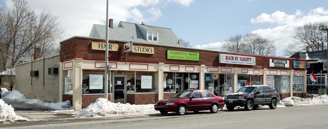
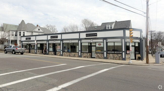
Property Record
1108 Main St, Wakefield, MA 01880

NEARBY LISTINGS FOR SALE OR LEASE
Property Detail
1108 Main St
Storebuilding
Middlesex
X
Massachusetts
25017C0427F
0.14 AC
2025
Lynnfield/Wakefield
2025
Boston
335400
Boston-Cambridge-Newton, MA-NH
5,008 SF
WAKE-000034-000335-000010
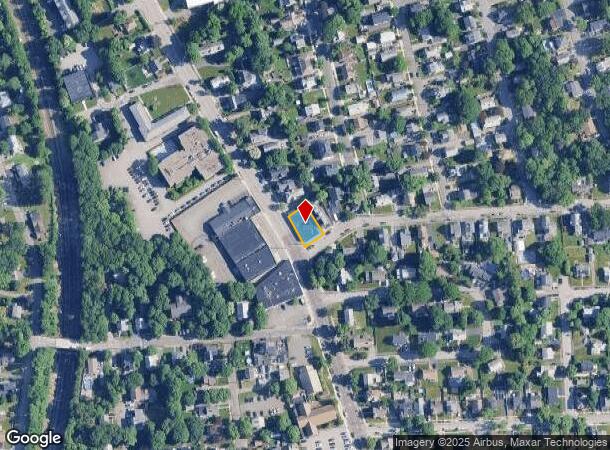
DEMOGRAPHICS near 1108 Main St
1 Mile
3 Mile
5 Mile
2024 Total Population
13,820
103,689
344,825
2029 Population
13,587
102,444
338,500
Pop Growth 2024-2029
(1.69%)
(1.20%)
(1.83%)
Average Age
43
43
41
2024 Total Households
5,374
42,338
132,927
HH Growth 2024-2029
(1.80%)
(1.29%)
(1.87%)
Median Household Inc
$128,162
$112,606
$100,732
Avg Household Size
2.50
2.40
2.50
2024 Avg HH Vehicles
2.00
2.00
2.00
Median Home Value
$711,509
$680,855
$658,979
Median Year Built
1949
1957
1954
Nearby Places
Map Layers
Map Styles
 Street
 Aerial
- Restaurants
- Banks
- Shops
- Fitness
- Groceries
PUBLIC TRANSPORTATION
TRANSIT/SUBWAY
Greenwood (Haverhill Line - Massachusetts Bay Transportation Authority Commuter Rail (Purple Line))
DRIVE
WALK
Distance
Greenwood (Haverhill Line - Massachusetts Bay Transportation Authority Commuter Rail (Purple Line))
1 min
13 min
0.4 mi
Melrose Highlands (Haverhill Line - Massachusetts Bay Transportation Authority Commuter Rail (Purple Line))
DRIVE
WALK
Distance
Melrose Highlands (Haverhill Line - Massachusetts Bay Transportation Authority Commuter Rail (Purple Line))
3 min
16 min
0.8 mi
COMMUTER RAIL
Greenwood (Haverhill Line - Massachusetts Bay Transportation Authority Commuter Rail (Purple Line))
DRIVE
WALK
Distance
Greenwood (Haverhill Line - Massachusetts Bay Transportation Authority Commuter Rail (Purple Line))
1 min
8 min
0.4 mi
Melrose Highlands (Haverhill Line - Massachusetts Bay Transportation Authority Commuter Rail (Purple Line))
DRIVE
WALK
Distance
Melrose Highlands (Haverhill Line - Massachusetts Bay Transportation Authority Commuter Rail (Purple Line))
3 min
16 min
0.8 mi
AIRPORT
General Edward Lawrence Logan International
DRIVE
WALK
Distance
General Edward Lawrence Logan International
21 min
9.9 mi
Manchester Boston Regional
DRIVE
WALK
Distance
Manchester Boston Regional
62 min
44.1 mi
SALE & LEASE HISTORY
LISTING DATE
SALE/LEASE

Sep 25, 2016
For Lease
Apr 16, 2018
For Lease
Nearby Properties
Address
Land Use
TOTAL SIZE
Lot Size
Zoning
Address
Land Use
TOTAL SIZE
Lot Size
Zoning
19,308 SF
82.36 AC
NA
Address
Land Use
TOTAL SIZE
Lot Size
Zoning
14.97 AC
C
Address
Land Use
TOTAL SIZE
Lot Size
Zoning
194,880 SF
35.42 AC
NA
Address
Land Use
TOTAL SIZE
Lot Size
Zoning
269,070 SF
21.74 AC
NA
Address
Land Use
TOTAL SIZE
Lot Size
Zoning
0.47 AC
M
Address
Land Use
TOTAL SIZE
Lot Size
Zoning
330,020 SF
7.32 AC
NA
Address
Land Use
TOTAL SIZE
Lot Size
Zoning
334,150 SF
28 AC
NA
Address
Land Use
TOTAL SIZE
Lot Size
Zoning
213,401 SF
15.16 AC
B
Address
Land Use
TOTAL SIZE
Lot Size
Zoning
720 SF
632 AC
SA8
Address
Land Use
TOTAL SIZE
Lot Size
Zoning
169,840 SF
16.70 AC
NA
Address
Land Use
TOTAL SIZE
Lot Size
Zoning
31.56 AC
HB
Address
Land Use
TOTAL SIZE
Lot Size
Zoning
267,277 SF
60 AC
MD
Address
Land Use
TOTAL SIZE
Lot Size
Zoning
4.58 AC
HB
Address
Land Use
TOTAL SIZE
Lot Size
Zoning
217,937 SF
8.40 AC
I
Address
Land Use
TOTAL SIZE
Lot Size
Zoning
228,797 SF
10.61 AC
MD
Address
Land Use
TOTAL SIZE
Lot Size
Zoning
172,056 SF
I
Address
Land Use
TOTAL SIZE
Lot Size
Zoning
5.63 AC
C
Address
Land Use
TOTAL SIZE
Lot Size
Zoning
8.17 AC
RB
Address
Land Use
TOTAL SIZE
Lot Size
Zoning
6.28 AC
RB
Address
Land Use
TOTAL SIZE
Lot Size
Zoning
9 AC
C/R
Address
Land Use
TOTAL SIZE
Lot Size
Zoning
14,760 SF
1 AC
SR
Address
Land Use
TOTAL SIZE
Lot Size
Zoning
63 AC
RESA
Address
Land Use
TOTAL SIZE
Lot Size
Zoning
115,000 SF
2.64 AC
RESB
Address
Land Use
TOTAL SIZE
Lot Size
Zoning
11.06 AC
RB
Address
Land Use
TOTAL SIZE
Lot Size
Zoning
155,686 SF
2.88 AC
I
Address
Land Use
TOTAL SIZE
Lot Size
Zoning
5.09 AC
R-1
Address
Land Use
TOTAL SIZE
Lot Size
Zoning
168,178 SF
15.33 AC
NA
Address
Land Use
TOTAL SIZE
Lot Size
Zoning
190,643 SF
38.88 AC
OS
Address
Land Use
TOTAL SIZE
Lot Size
Zoning
6,883 SF
16.90 AC
NA
Address
Land Use
TOTAL SIZE
Lot Size
Zoning
66,282 SF
258.01 AC
OS
The World's #1 Commercial Real Estate Marketplace
Connect with us
© 2025 CoStar Group
The information above has been obtained from sources believed reliable. While we do not doubt its accuracy we have not verified it and make no guarantee, warranty or representation about it. It is your responsibility to independently confirm its accuracy and completeness. Any projections, opinions, assumptions, or estimates used are for example only and do not represent the current or future performance of the property. The value of this transaction to you depends on tax and other factors which should be evaluated by your tax, financial, and legal advisors. You and your advisors should conduct a careful, independent investigation of the property to determine to your satisfaction the suitability of the property for your needs.