Property Record
1109 E Mccart St, Krum, TX 76249
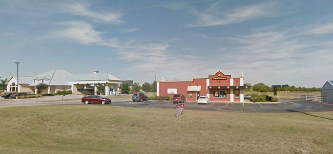
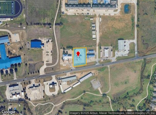

Property Detail
1109 E Mccart St
Dallas-Fort Worth-Arlington, TX
Hopkins Crossing
R268327
HOPKINS CROSSING BLK A LOT 3R-2 (PT)
Commercialnec
Denton
X
Texas
48121C0215G
3r-2
2024
0.80 AC
2025
Northwest Fort Worth
020207
Dallas/Ft Worth
1,941 SF
NEARBY LISTINGS FOR SALE OR LEASE
DEMOGRAPHICS near 1109 E Mccart St
1 mile
3 mile
5 mile
2024 Total Population
5,950
9,232
30,304
2029 Population
7,148
11,127
37,183
Pop Growth 2024-2029
+ 20.13%
+ 20.53%
+ 22.70%
Average Age
37
38
37
2024 Total Households
1,949
3,032
12,114
HH Growth 2024-2029
+ 20.52%
+ 20.84%
+ 23.49%
Median Household Inc
$103,069
$102,149
$64,008
Avg Household Size
3.00
3.00
2.50
2024 Avg HH Vehicles
2.00
3.00
2.00
Median Home Value
$282,470
$298,430
$267,007
Median Year Built
2003
2002
1996
Nearby Places
Map Layers
Map Styles
 Street
 Aerial
Transit
 Traffic
 Biking
Places
Listings with unknown addresses are not visible on the map
- Restaurants
- Banks
- Shops
- Fitness
- Groceries
PUBLIC TRANSPORTATION
COMMUTER RAIL
Downtown Denton Transit Center (A-train - Denton County Transportation Authority)
Drive
Walk
Distance
Downtown Denton Transit Center (A-train - Denton County Transportation Authority)
15 min
8.4 mi
AIRPORT
Dallas-Fort Worth International
Drive
Walk
Distance
Dallas-Fort Worth International
42 min
33.8 mi
Freight Ports
Port of Shreveport
Drive
Walk
Distance
Port of Shreveport
261 min
240.4 mi
SALE & LEASE HISTORY
LISTING DATE
SALE/LEASE

Jun 26, 2019
For Sale
Dec 11, 2019
For Lease
Nearby Properties
Address
Land Use
TOTAL SIZE
Lot Size
Zoning
Address
Land Use
TOTAL SIZE
Lot Size
Zoning
702,810 SF
37.91 AC
Address
Land Use
TOTAL SIZE
Lot Size
Zoning
374,520 SF
23.62 AC
Address
Land Use
TOTAL SIZE
Lot Size
Zoning
167,850 SF
48.14 AC
Address
Land Use
TOTAL SIZE
Lot Size
Zoning
367,488 SF
22.80 AC
Address
Land Use
TOTAL SIZE
Lot Size
Zoning
141,468 SF
24.72 AC
Address
Land Use
TOTAL SIZE
Lot Size
Zoning
269,400 SF
22.20 AC
Address
Land Use
TOTAL SIZE
Lot Size
Zoning
164,211 SF
11.95 AC
Address
Land Use
TOTAL SIZE
Lot Size
Zoning
126,126 SF
9.45 AC
Address
Land Use
TOTAL SIZE
Lot Size
Zoning
86,702 SF
15.16 AC
Address
Land Use
TOTAL SIZE
Lot Size
Zoning
247,171 SF
20.30 AC
Address
Land Use
TOTAL SIZE
Lot Size
Zoning
200,794 SF
37.89 AC
Address
Land Use
TOTAL SIZE
Lot Size
Zoning
170,300 SF
19.66 AC
Address
Land Use
TOTAL SIZE
Lot Size
Zoning
337,607 SF
27.76 AC
Address
Land Use
TOTAL SIZE
Lot Size
Zoning
166,705 SF
6.21 AC
Address
Land Use
TOTAL SIZE
Lot Size
Zoning
66,330 SF
30 AC
Address
Land Use
TOTAL SIZE
Lot Size
Zoning
123,830 SF
12.26 AC
Address
Land Use
TOTAL SIZE
Lot Size
Zoning
14,220 SF
14.47 AC
Address
Land Use
TOTAL SIZE
Lot Size
Zoning
13,152 SF
15 AC
Address
Land Use
TOTAL SIZE
Lot Size
Zoning
18,198 SF
16.98 AC
Address
Land Use
TOTAL SIZE
Lot Size
Zoning
110.88 AC
Address
Land Use
TOTAL SIZE
Lot Size
Zoning
76,600 SF
4.96 AC
Address
Land Use
TOTAL SIZE
Lot Size
Zoning
63,000 SF
8.70 AC
Address
Land Use
TOTAL SIZE
Lot Size
Zoning
18,690 SF
9.33 AC
Address
Land Use
TOTAL SIZE
Lot Size
Zoning
51,840 SF
5.93 AC
Address
Land Use
TOTAL SIZE
Lot Size
Zoning
99,000 SF
5.90 AC
Address
Land Use
TOTAL SIZE
Lot Size
Zoning
29,411 SF
17.89 AC
Address
Land Use
TOTAL SIZE
Lot Size
Zoning
71,906 SF
69.06 AC
Address
Land Use
TOTAL SIZE
Lot Size
Zoning
22,043 SF
4.71 AC
Address
Land Use
TOTAL SIZE
Lot Size
Zoning
43,680 SF
4.24 AC
Address
Land Use
TOTAL SIZE
Lot Size
Zoning
56,901 SF
3.97 AC
The World's #1 Commercial Real Estate Marketplace
Connect with us
© 2026 CoStar Group
The information above has been obtained from sources believed reliable. While we do not doubt its accuracy we have not verified it and make no guarantee, warranty or representation about it. It is your responsibility to independently confirm its accuracy and completeness. Any projections, opinions, assumptions, or estimates used are for example only and do not represent the current or future performance of the property. The value of this transaction to you depends on tax and other factors which should be evaluated by your tax, financial, and legal advisors. You and your advisors should conduct a careful, independent investigation of the property to determine to your satisfaction the suitability of the property for your needs.