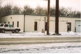
Property Record
1109 Memorial Hwy, Bismarck, ND 58504

NEARBY LISTINGS FOR SALE OR LEASE
Property Detail
1109 Memorial Hwy
Bismarck, ND
Park Hill (Aud Lots)
0125-029-001
PARK HILL (AUD LOTS) ALL THAT PART OF AUD LOT 29 LYING SELY OF PARCEL B EXC PARCELS 1 & 2 OWNED BY CITY & EXC STRIP 26' WIDE
Apartment
Burleigh
X
North Dakota
38015C0795E
29
2024
2.27 AC
2024
Riverfront
010600
Other Market Areas
55,480 SF
DEMOGRAPHICS near 1109 Memorial Hwy
1 Mile
3 Mile
5 Mile
2024 Total Population
6,773
58,339
98,510
2029 Population
6,971
60,133
101,703
Pop Growth 2024-2029
+ 2.92%
+ 3.08%
+ 3.24%
Average Age
40
41
40
2024 Total Households
3,154
26,094
42,313
HH Growth 2024-2029
+ 3.14%
+ 3.15%
+ 3.28%
Median Household Inc
$55,155
$59,638
$66,432
Avg Household Size
2.00
2.10
2.20
2024 Avg HH Vehicles
2.00
2.00
2.00
Median Home Value
$239,418
$249,869
$258,301
Median Year Built
1969
1978
1984
Nearby Places
Map Layers
Map Styles
 Street
 Aerial
- Restaurants
- Banks
- Shops
- Fitness
- Groceries
PUBLIC TRANSPORTATION
AIRPORT
Bismarck Municipal
DRIVE
WALK
Distance
Bismarck Municipal
18 min
5.9 mi
Nearby Properties
Address
Land Use
TOTAL SIZE
Lot Size
Zoning
Address
Land Use
TOTAL SIZE
Lot Size
Zoning
45.23 AC
CG
Address
Land Use
TOTAL SIZE
Lot Size
Zoning
13.47 AC
PUD
Address
Land Use
TOTAL SIZE
Lot Size
Zoning
93,860 SF
1.44 AC
HM
Address
Land Use
TOTAL SIZE
Lot Size
Zoning
Address
Land Use
TOTAL SIZE
Lot Size
Zoning
60,105 SF
11.86 AC
RM30
Address
Land Use
TOTAL SIZE
Lot Size
Zoning
70,182 SF
3.83 AC
PUD
Address
Land Use
TOTAL SIZE
Lot Size
Zoning
44,652 SF
13.84 AC
RM30
Address
Land Use
TOTAL SIZE
Lot Size
Zoning
6.29 AC
RM30
Address
Land Use
TOTAL SIZE
Lot Size
Zoning
81,092 SF
4.17 AC
HM
Address
Land Use
TOTAL SIZE
Lot Size
Zoning
38,467 SF
13.89 AC
CG
Address
Land Use
TOTAL SIZE
Lot Size
Zoning
16.12 AC
CG
Address
Land Use
TOTAL SIZE
Lot Size
Zoning
13.98 AC
CG
Address
Land Use
TOTAL SIZE
Lot Size
Zoning
51,723 SF
1.69 AC
HM
Address
Land Use
TOTAL SIZE
Lot Size
Zoning
10.84 AC
CG
Address
Land Use
TOTAL SIZE
Lot Size
Zoning
57,580 SF
8.85 AC
CG
Address
Land Use
TOTAL SIZE
Lot Size
Zoning
14.70 AC
MA
Address
Land Use
TOTAL SIZE
Lot Size
Zoning
8.64 AC
ETZ
Address
Land Use
TOTAL SIZE
Lot Size
Zoning
62,652 SF
2.34 AC
HM
Address
Land Use
TOTAL SIZE
Lot Size
Zoning
99,684 SF
2.33 AC
MA
Address
Land Use
TOTAL SIZE
Lot Size
Zoning
74,250 SF
5.63 AC
PUD
Address
Land Use
TOTAL SIZE
Lot Size
Zoning
15,656 SF
8.98 AC
RM30
Address
Land Use
TOTAL SIZE
Lot Size
Zoning
25.59 AC
CG
Address
Land Use
TOTAL SIZE
Lot Size
Zoning
10.58 AC
CG
Address
Land Use
TOTAL SIZE
Lot Size
Zoning
10.14 AC
CG
Address
Land Use
TOTAL SIZE
Lot Size
Zoning
14.65 AC
CG
Address
Land Use
TOTAL SIZE
Lot Size
Zoning
81.73 AC
RMH
Address
Land Use
TOTAL SIZE
Lot Size
Zoning
88,263 SF
8.58 AC
CG
Address
Land Use
TOTAL SIZE
Lot Size
Zoning
52,206 SF
3.73 AC
CG
Address
Land Use
TOTAL SIZE
Lot Size
Zoning
48,661 SF
4.91 AC
CG
Address
Land Use
TOTAL SIZE
Lot Size
Zoning
68,211 SF
10 AC
RT
The World's #1 Commercial Real Estate Marketplace
Connect with us
© 2026 CoStar Group
The information above has been obtained from sources believed reliable. While we do not doubt its accuracy we have not verified it and make no guarantee, warranty or representation about it. It is your responsibility to independently confirm its accuracy and completeness. Any projections, opinions, assumptions, or estimates used are for example only and do not represent the current or future performance of the property. The value of this transaction to you depends on tax and other factors which should be evaluated by your tax, financial, and legal advisors. You and your advisors should conduct a careful, independent investigation of the property to determine to your satisfaction the suitability of the property for your needs.