Property Record
320 N 110Th St, Kansas City, KS 66111

NEARBY LISTINGS FOR SALE OR LEASE
Property Detail
320 N 110Th St
Kansas City, MO-KS
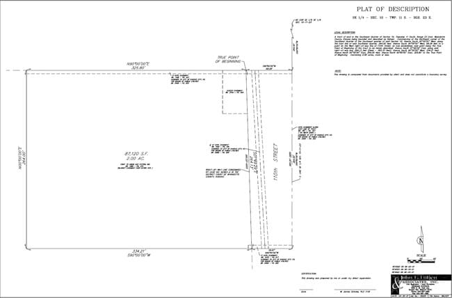
9489, S10, T11, R23, ACRES 2.04, BEG 264FT S & 68.28FT W OF NE COR SE1/4 SE1/4; S02E-264.13FT, W 334.21FT, N 264FT, E 325.8FT TO POB CONTG 2AC M/L
948907
Wyandotte
Commercialnec
Kansas
X
7
20209C0130D
2 AC
2025
Kansas City KS
2025
Kansas City
044702
DEMOGRAPHICS near 320 N 110Th St
1 Mile
3 Mile
5 Mile
2024 Total Population
127
10,852
54,504
2029 Population
123
10,492
53,279
Pop Growth 2024-2029
(3.15%)
(3.32%)
(2.25%)
Average Age
40
40
39
2024 Total Households
50
4,362
20,221
HH Growth 2024-2029
(4.00%)
(3.35%)
(2.48%)
Median Household Inc
$97,916
$93,543
$84,396
Avg Household Size
2.50
2.40
2.60
2024 Avg HH Vehicles
3.00
2.00
2.00
Median Home Value
$239,285
$246,999
$219,029
Median Year Built
1986
1999
1983
Nearby Places
Map Layers
Map Styles
 Street
 Aerial
- Restaurants
- Banks
- Shops
- Fitness
- Groceries
PUBLIC TRANSPORTATION
AIRPORT
Kansas City International
DRIVE
WALK
Distance
Kansas City International
31 min
25.0 mi
SALE & LEASE HISTORY
LISTING DATE
SALE/LEASE

Jun 29, 2018
For Sale
Jun 29, 2018
For Lease
Nearby Properties
Address
Land Use
TOTAL SIZE
Lot Size
Zoning
Address
Land Use
TOTAL SIZE
Lot Size
Zoning
920,306 SF
90.21 AC
Address
Land Use
TOTAL SIZE
Lot Size
Zoning
466.24 AC
Address
Land Use
TOTAL SIZE
Lot Size
Zoning
103,299 SF
13.41 AC
Address
Land Use
TOTAL SIZE
Lot Size
Zoning
87,287 SF
10.30 AC
Address
Land Use
TOTAL SIZE
Lot Size
Zoning
123,957 SF
16.88 AC
Address
Land Use
TOTAL SIZE
Lot Size
Zoning
61,159 SF
2.45 AC
Address
Land Use
TOTAL SIZE
Lot Size
Zoning
176.36 AC
Address
Land Use
TOTAL SIZE
Lot Size
Zoning
700,029 SF
49.54 AC
Address
Land Use
TOTAL SIZE
Lot Size
Zoning
51,739 SF
46.71 AC
Address
Land Use
TOTAL SIZE
Lot Size
Zoning
37,521 SF
11.77 AC
Address
Land Use
TOTAL SIZE
Lot Size
Zoning
108,385 SF
22.86 AC
KAG
Address
Land Use
TOTAL SIZE
Lot Size
Zoning
75,027 SF
13.51 AC
Address
Land Use
TOTAL SIZE
Lot Size
Zoning
268,951 SF
63.35 AC
Address
Land Use
TOTAL SIZE
Lot Size
Zoning
16,603 SF
133.44 AC
Address
Land Use
TOTAL SIZE
Lot Size
Zoning
66.54 AC
Address
Land Use
TOTAL SIZE
Lot Size
Zoning
186,293 SF
63.45 AC
Address
Land Use
TOTAL SIZE
Lot Size
Zoning
96,144 SF
38.53 AC
Address
Land Use
TOTAL SIZE
Lot Size
Zoning
122,784 SF
13.05 AC
Address
Land Use
TOTAL SIZE
Lot Size
Zoning
58,897 SF
141.52 AC
BA1
Address
Land Use
TOTAL SIZE
Lot Size
Zoning
39,012 SF
13.38 AC
Address
Land Use
TOTAL SIZE
Lot Size
Zoning
116,455 SF
16.49 AC
Address
Land Use
TOTAL SIZE
Lot Size
Zoning
40,016 SF
5.20 AC
Address
Land Use
TOTAL SIZE
Lot Size
Zoning
86,176 SF
49.23 AC
KAG
Address
Land Use
TOTAL SIZE
Lot Size
Zoning
141,032 SF
68.59 AC
A1
Address
Land Use
TOTAL SIZE
Lot Size
Zoning
28,210 SF
317.17 AC
Address
Land Use
TOTAL SIZE
Lot Size
Zoning
390,400 SF
59.71 AC
Address
Land Use
TOTAL SIZE
Lot Size
Zoning
69,406 SF
29.75 AC
Address
Land Use
TOTAL SIZE
Lot Size
Zoning
57,384 SF
18.81 AC
CPO
Address
Land Use
TOTAL SIZE
Lot Size
Zoning
1,036,732 SF
25.08 AC
KC1
Address
Land Use
TOTAL SIZE
Lot Size
Zoning
1,542 SF
48.61 AC
KR1
The World's #1 Commercial Real Estate Marketplace
Connect with us
© 2025 CoStar Group
The information above has been obtained from sources believed reliable. While we do not doubt its accuracy we have not verified it and make no guarantee, warranty or representation about it. It is your responsibility to independently confirm its accuracy and completeness. Any projections, opinions, assumptions, or estimates used are for example only and do not represent the current or future performance of the property. The value of this transaction to you depends on tax and other factors which should be evaluated by your tax, financial, and legal advisors. You and your advisors should conduct a careful, independent investigation of the property to determine to your satisfaction the suitability of the property for your needs.